


Agricultural News
Rainfall Chances Remain Good- The Latest Graphic Explains
Wed, 26 Sep 2012 05:43:48 CDT
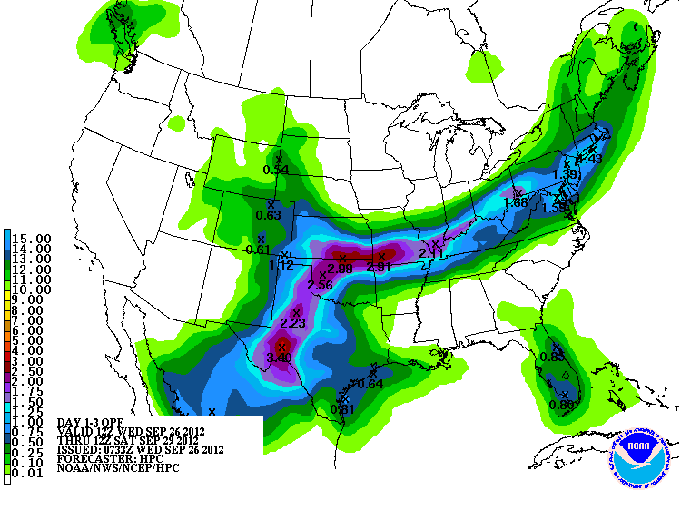 Chances of significant rainfall over the next three days continue to be a part of the forecast from the HPC- the Hydrometeorological Prediction Center. The graphic above shows how the Pacific system Miriam may swing a couple of inches of rainfall across west central and up into northern Oklahoma between now and Saturday- this latest map is effective as of today- Wednesday morning.
Scattered showers have given some rainfall to locations largely south of I-40 overnight, with the largest amounts captured by the Oklahoma Mesonet found in Hinton with 1.19 inches of rain and Hobart with .98 inches of rainfall.
Rainfall chances continue to be a part of the forecast in much of Oklahoma through Saturday. Alan Crone with the News on 6 in Tulsa offers an explanation for that in his morning blog- Alan says "Storms formed last night across western OK and moved eastward overnight. These storms have weakened across Northern OK this morning, but a few strong to severe storms are still possible across the southern part of the state for the early morning hours. A stationary boundary located across southern Kansas will get a shove southward during the next few hours and will end up positioned across the northern third of state late this afternoon and evening. Another weak upper level wave will approach the area helping to spark off scattered storms that will form small clusters of storms. A few of these could be severe with large hail and damaging wind gusts.
"This active weather pattern should remain through at least Midday Friday before the focus will be shifting southward across the Red River Valley into Texas. Remnant moisture from Hurricane Miriam currently off the Baja will move across the southwestern U.S. and into the southern plains. As this occurs, a surface boundary will slide southward across Oklahoma Friday with a surface ridge of high pressure building down across the Midwest. This will effectively keep most of the Miriam moisture confined to our south Saturday. I'll keep a slight chance of showers and storms Saturday morning (for Tulsa), but if all goes as planned, the higher likelihood will be south of I-40 into Texas. Sunday appears super nice for northern Oklahoma and southern Kansas with sunshine and highs in the upper 70s after morning lows in the 50s.
"The pattern should be nice and fall like early next week with morning lows in the 50s and 60s with highs in the lower 80s."
WebReadyTM Powered by WireReady® NSI
Top Agricultural News
More Headlines...


