


Agricultural News
Oklahoma's Homegrown Disaster Rivals Hurricane Sandy, Climatologist Says
Mon, 29 Oct 2012 15:32:40 CDT
While Hurricane Sandy may be grabbing all the headlines, Oklahoma is still in the middle of its own multi-billion-dollar disaster: the drought of 2010-2012, says Gary McManus of the Oklahoma Climate Survey. It has now been more than a month since much of northwest Oklahoma has seen more than a tenth of an inch of rainfall in a single day, and even longer since that area has seen a quarter of an inch.
The just-planted Oklahoma wheat crop is reaching a disaster point. When Woods, Alfalfa, Grant, Garfield, Kay and Noble counties go largely without rainfall in September and October, bad things happen come harvest time.
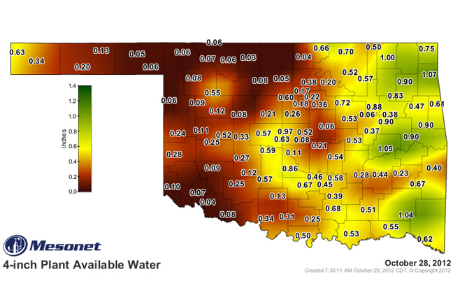
The new Plant Available Water maps from the Oklahoma Mesonet paint a rather bleak picture at this time. Plant available water is the amount of water (in inches) in the soil that is potentially available for plant uptake. You can find those maps for the 4-, 16- and 32-inch depths across the state by clicking here.
The state has now dropped more than 2 inches below normal (and 35% of normal) for the month with a statewide average of 1.1", the 20th driest Oct. 1-29 since 1921. Cherokee is still awaiting its first drop of moisture for the month, as are several stations across western Oklahoma.
McManus says Oklahoma pastures that still had moisture to work with won't be making much of a contribution due to the very early statewide freeze that occurred over the weekend.
WebReadyTM Powered by WireReady® NSI
Top Agricultural News
More Headlines...


