


Agricultural News
Rains Welcomed in Southwest Oklahoma and Points East- The Latest Map
Mon, 24 Nov 2014 06:08:35 CST
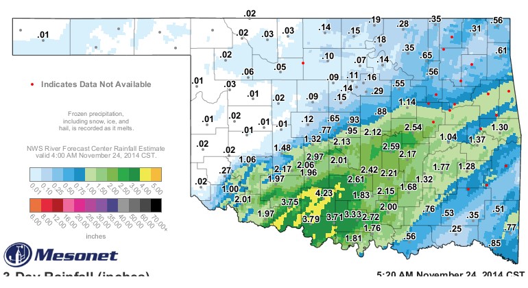 Rainfall across mostly south central and parts of southwest Oklahoma was most welcome by farmers and ranchers in those counties that received the rain from Friday and Saturday. Rainfall totals exceeded three inches at a number of Mesonet stations in Comanche, Stephens, Cotton, Jefferson and Carter Counties. Ketchum Ranch in Stephens County wins the prize for more than four inches in the Mesonet rain gauge.
In addition, a lot of locations got an inch or more- including Altus and Hobart both picking up an inch of rain, Fort Cobb right at an inch and a half, Apache two inches and Chickasha just under three inches. The line of rain versus little or no rain was pretty clear- Minco got 1.3 inches of rainfall while El Reno recorded just .12 of an inch. The El Reno rainfall was the norm for west central, north central and northwestern Oklahoma. The rain did stretch from Altus across south central Oklahoma as far east as Okemah that recorded two and half inches of rain and Sallisaw that got 1.3 inches at their Mesonet station. To see an interactive version of the above map- click here for the three day rainfall total map as found on the Oklahoma Mesonet website.
As far as what may lie ahead- Alan Crone with the News on 6 in Tulsa has a nice synopsis of the week ahead. He writes in his morning blog "Tuesday will be the coldest day for the next few days with temps in the mid to upper 20s for the morning followed by highs around 50. A compact upper level system will dive down the northwest flow into the mid-Missouri Valley Wednesday but will have little impact on our weather. Wednesday and Thanksgiving Day should feature morning lows in the mid-30s and highs in the mid to upper 50s with sunshine. This will not be the case along the east coast. If you have air travel planned Wednesday or Thursday along the Mid-Atlantic, be prepared for possible delays. A strong system will move up the east coast with rain and snow along some of the mega-metropolis areas of the nation Wednesday and also early Thanksgiving Day. This system could also cause delays elsewhere in the air traffic system.
"The end of the week into the weekend has been extremely poor in the model data for the past week or so but seems to have settled into a mild weather solution for much of the southern plains. Gusty south winds Friday will help to warm up the area with highs in the 60s into the upper 60s Saturday before a cold front moves into the state late Saturday or Sunday before a strong looking storm system will approach the area early next week. Red Letter GFS would support a very strong system around Wednesday of next week with heavy rainfall and thunderstorm potential."
WebReadyTM Powered by WireReady® NSI
Top Agricultural News
More Headlines...


