


Agricultural News
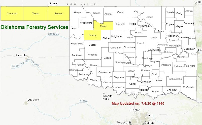
Much Needed Rains Fall Across the State, but Burn Bans Still Active in Cimarron, Texas, Beaver, Dewey and Major Counties
Mon, 13 Jul 2020 12:20:11 CDT
 According to the Latest Fire Situation Report, the welcome rain over the weekend has helped with the Oklahoma fire danger.
Statewide Discussion: Rainfall associated with several rounds of storms occurring Friday through this morning provided wetting rains in several locations prompting a welcomed recovery in live fuel moisture; however the southwest (generally along and south of I-40 and west of I-44) have lagged well behind in rainfall with several locations posting 15-23 days since wetting rains.
Additionally, the spotty nature of rainfall amounts in the Oklahoma Panhandle counties has resulted in several dry pockets remaining, and while the some of the looming wildfire threat has diminished some areas remain a concern.
Today: The highest fire danger indices today will reside in southwestern Oklahoma where very hot temperatures and low afternoon relative humidity values will promote receptive fuels. Storm chances in the Oklahoma Panhandle will present some threat for lightning ignited fires especially of those storms are isolated in nature. Elsewhere in Oklahoma, the fire danger threat has been greatly diminished with prompting resurgent green-up and live fuel moisture improvements.
· Southwestern Oklahoma: South and west of a line from Roger Mills County to Cotton County, temperatures 100-109? and afternoon relative humidity values 14-21% will result in fine-dead fuel moisture values as low as 3% at some locations. Live-herbaceous fuel moisture has been stressed with the continued heat exhibiting increasing availability. Southerly winds will increase into the afternoon sustained 12-18 with gusts 22-28 mph. Fires that become established in continuous grass dominated fuels will have potential to exhibit head fire rates of spread 66-90 ft./min. and flame lengths averaging 8 ft. Problematic fire behavior in brush fuel types including juniper and oak scrub cannot be ruled out including single tree torching and short-range spotting.
Near-term Outlook: Near-critical fire weather is forecast for southwest Oklahoma tomorrow (July 14). Marginal overnight moisture recovery will likely prompt an extended burning period developing by midday and persisting well into the evening hours holding the highest fire danger focus on the area. Some storm chances will be present into Wednesday in the Oklahoma Panhandle and northwestern Oklahoma holding potential for lightning ignitions in place especially in the localized dry pockets that remain. The heat is forecasted to remain in place through the week.
Burn Bans: Cimarron, Texas, Beaver, Dewey and Major Counties.
PROTECTION AREA STATISTICS 07/10/2020 thru 07/13/2020
NE Area No New Activity
EC Area No New Activity
SE Area 4 Fires Burned 9 Acres (Cause: 4-Incendiary)
Large / Significant Fire Activity within the Protection Area: No New Activity
Fire Activity with OFS Response outside of the Protection Area: No New Activity
OFS Prescribed Fire Activity: No New Activity
FIRE DEPARTMENT STATISTICS from www.firereporting.ok.gov recorded on 07/10/2020 thru 07/13/2020
· 2 Fires Burned 162 Acres (Cause: 1-Equipment, 1-Electrical)
· Additional Wildfire Activity noted through informal reporting and media outlets.
WebReadyTM Powered by WireReady® NSI
Top Agricultural News
More Headlines...


