

Agricultural News
Oklahoma's Drought Monitor Readings Improve Marginally in Latest Weekly Report
Thu, 11 Nov 2021 14:06:39 CST
 Oklahoma saw slight improvement in the latest Drought Monitor report. In eastern Texas and Oklahoma, and in far northwest Louisiana and western Arkansas, widespread rain over a half inch fell this week. As a result, many areas from the Dallas-Fort Worth Metroplex and eastward along the Red River saw improvements to ongoing drought and dryness. Improvements also occurred in south Texas. In parts of southwest Texas that did not see rain, some worsening of drought conditions occurred, due to increasing precipitation deficits and lessening soil moisture. Conditions also worsened in parts of northern Louisiana and southern Arkansas where short-term precipitation deficits increased. Most of the region saw cooler than normal temperatures this week, with widespread readings between 6 and 10 degrees below normal in east Texas, Louisiana, and Arkansas. The western reaches of the South region saw near- or above-normal temperatures.
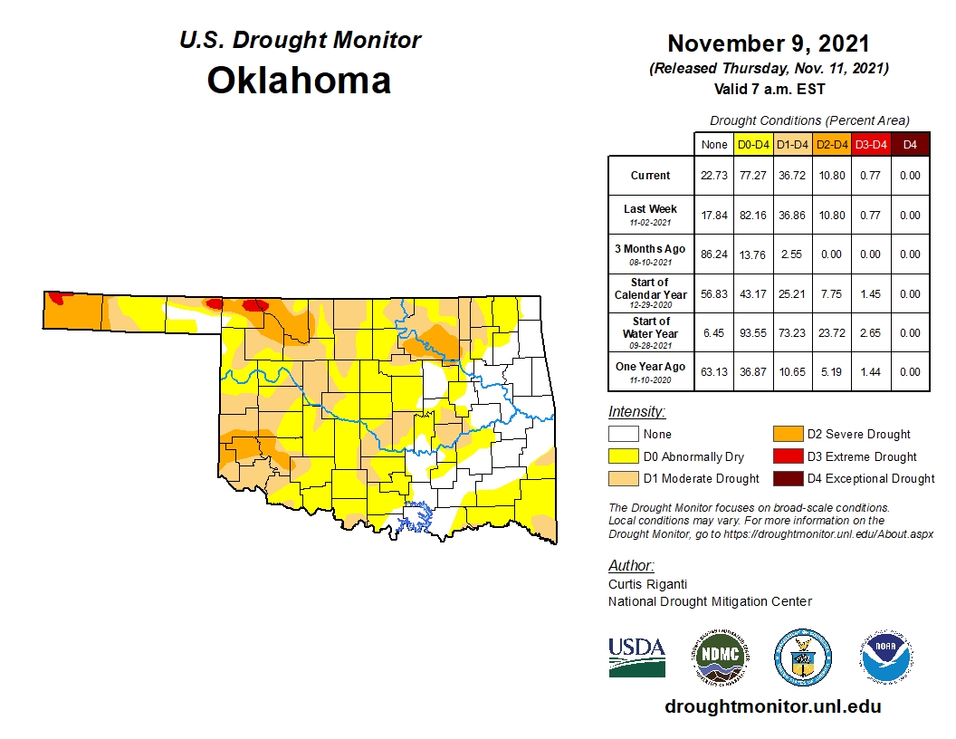
This week's Drought Monitor showed a five point improvement in Oklahoma's numbers to 77.27 percent of the state in Abnormally dry or worse condition- compared to 82.16 percent a week ago. The actual drought conditions of 36.72 percent of mostly moderate to extreme drought was virtually unchnaged from a week ago of 36.86 percent. Compared to the start of 2021- our drought mo itor ratings of abnormally dry or worse have increased by over 30 percentage points of 43.17 percent.
Click here for the PDF image of the Oklahoma Drought Monitor ratings as of Thursday morning, November 11, 2021.
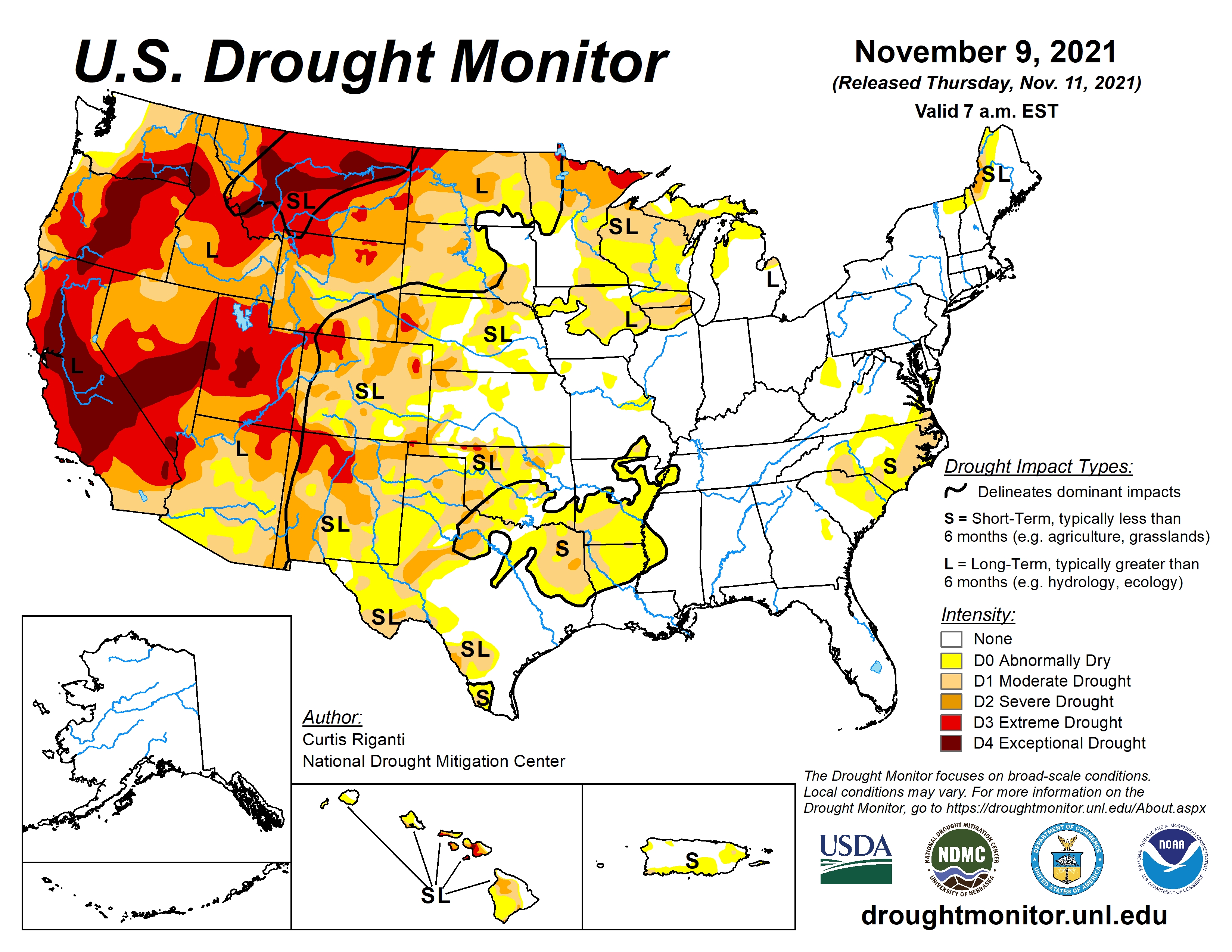
Nationally, Over the last week, multiple storm systems moved into the Pacific Coast, resulting in mostly beneficial precipitation in western portions of Washington, Oregon, and northern California. Some of these areas saw improvements to ongoing drought conditions as a result of these precipitation events. A few other spots in the West, primarily north and east of the Great Basin, saw some precipitation, but conditions in other parts of the West were largely dry.
Outside of the Pacific Coast states, only a few changes were made to the Drought Monitor this week in the West. For more detail on these changes, please see the West region paragraph below. Elsewhere in the contiguous United States, widespread rain, amounting to between half an inch and 2 inches, fell in the Southern Great Plains, primarily along and to the east of Interstate 35. As a result, some areas along the Texas/Oklahoma border and parts of south Texas saw improvements to drought conditions. Farther east, heavy rainfall struck parts of Florida and the southeast U.S. coastline, resulting in some improvements to dryness in Florida, Georgia, and southern South Carolina. In drier parts of North Carolina and adjacent South Carolina, drought conditions remained the same or worsened. While not enough to improve ongoing dryness and drought in the Michigan UP, lake effect snow staved off any worsening of drought. Along the Pacific Coast, temperatures were generally within a few degrees of normal this week. Farther east, roughly northwest of a line from the Great Lakes to El Paso, temperatures were well above normal. Parts of the Dakotas saw temperatures 6 to 10 degrees warmer than normal. Southeast of that line, temperatures were mostly cooler than normal, with parts of Arkansas, Louisiana, and Texas falling 6 to 10 degrees below normal.
Click here for the latest national Drought Monitor Report.
WebReadyTM Powered by WireReady® NSI
Top Agricultural News
More Headlines...


