

Agricultural News
Drought Monitor Report Shows More Than 90% of Oklahoma Abnormally Dry or Worse
Thu, 09 Dec 2021 12:42:49 CST
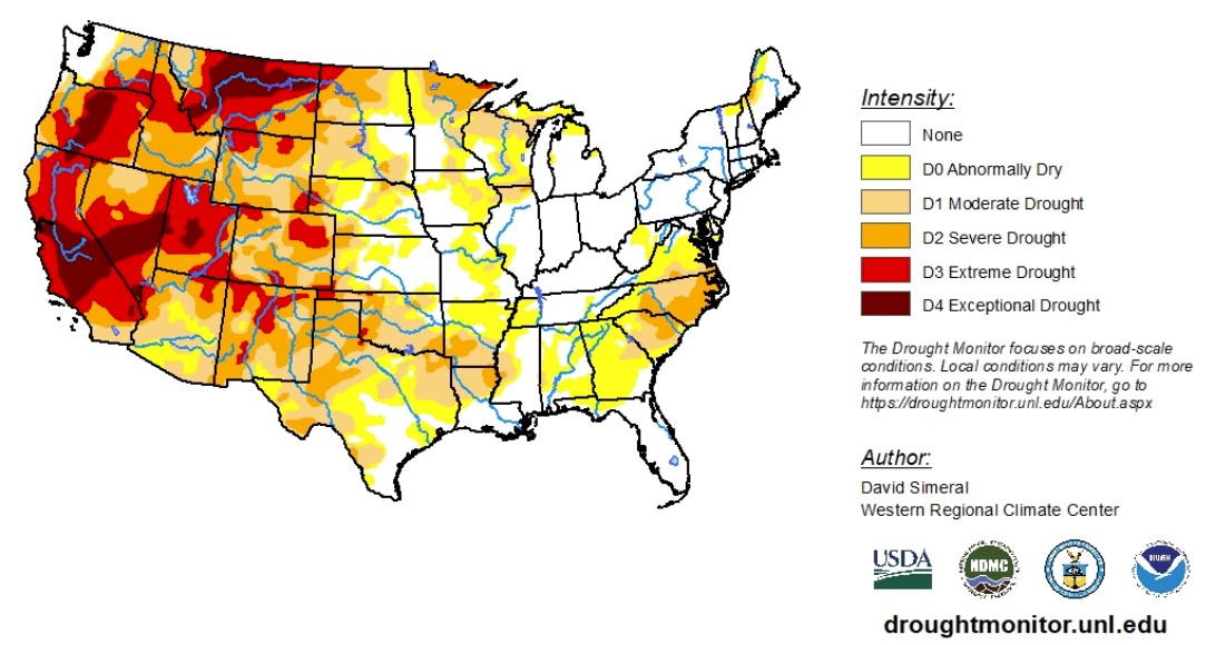
 According to the latest U.S. Drought Monitor report, drought-affected areas expanded and intensified on the map in areas of the South, including Texas and Oklahoma, where overall warm and dry conditions have prevailed during the past 30-to-120-day period. Across areas of the Northern Plains and Upper Midwest, light-to-heavy snowfall accumulations were observed during the past week. Out West, some areas including the northern Cascades, Sierra Nevada and the northern and central Rocky Mountains, received much-needed snowfall this past week. However, basin-level snowpack conditions remained below normal across the entire western United States.
With autumn ending, the Lower 48 experienced its third-warmest fall on record, with the largest mean temperature departures from average observed across areas of the Northern and Central Plains, according to NOAA's National Centers for Environmental Information (NCEI). In terms of fall precipitation, the driest conditions were observed across parts of the Southwest, Texas, Montana, Wisconsin and the Carolinas.
With data ranging from Dec. 2 to Dec. 7, 2021, the High Plains saw widespread degradation in response to anomalously warm temperatures, short-term precipitation deficits, declining soil moisture levels, and elevated evaporative demand across the region. Moreover, impact reports from eastern Colorado are yielding concerns by producers about winter wheat stands as well as declining pasture and range conditions. Most of the region was unseasonably warm and dry with average temperatures ranging from 2 to 12 degrees above normal with the greatest departures observed in eastern portions of Colorado and Wyoming, Kansas, and Nebraska. In eastern Colorado, average maximum temperatures for the week ranged from 60 to 70 degrees.
The Southern Plains were also mainly dry with average temperatures that were well above normal and drought conditions degraded across much of the region, including Texas and Oklahoma. In the western portions of Oklahoma and Texas, the NASA Crop-CASMA application is showing significant negative soil moisture anomalies this month. In the Rolling Plains of Texas, some drought-related impacts have been reported, including reports of winter wheat crops continuing to struggle due to the lack of moisture.
In the West, poor snowpack conditions across the region and growing concern about water supplies after back-to-back dry winter seasons in California, as well as in other basins including the Colorado River Basin, are concerning. In California, the Department of Water Resources recently announced that the State Water Project's initial water allocation for 2022 will be at 0% in an unprecedented step to address the state's water supply in anticipation of another dry winter season. Other impacts of concern across the region include the delayed opening of ski areas across the region which is impacting local economies in mountain communities across the West.
To view the Contiguous U.S. Drought Map, click here.
Looking ahead, active weather patterns are expected to bring precipitation to the Cascades, Sierra Nevada, Great Basin and the Rockies in the next week. Little-to-no precipitation is expected for the Central Plains and Upper Midwest.
From Dec. 13 to Dec. 17, 2021, a moderate-to-high probability of above-normal temperatures is expected across most of the contiguous U.S. There is a moderate-to-high probability of above-normal precipitation across most of the western U.S. and portions of the Midwest and eastern portions of the Southern Plains.
To view the 6 - 10 Day Precipitation Outlook, click here.
To view the 6 - 10 Day Temperature Outlook, click here.
According to the Monthly Drought Outlook map, drought conditions look like they will remain but improve in the Pacific Northwest, Idaho and western Montana and Wyoming. Otherwise, drought conditions are set to persist or further develop in the rest of the West, Great Plains and Midwest.
To view the Monthly Drought Outlook map, click here.
Oklahoma
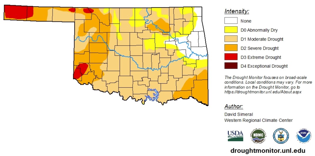
According to data as of Dec. 2 to Dec. 7, 2021, drought conditions in Oklahoma have further deteriorated. As of Dec. 7, 92.6% of the state is experiencing abnormally dry conditions or worse. Moderate drought conditions or worse changed from 60.7% to 81.9%. Severe drought conditions or worse changed from 15.9% to 28.7%. Extreme drought conditions changed from 2.2% to 4.4%.
According to the Mesonet, no recordable precipitation has fallen west of I-35 in the last 30 days.
Nearly all of Cimarron County is classified as in extreme drought. Extreme drought conditions are also reported in Beaver, Beckham, Greer, Harmon, Harper and Woods counties. Severe drought conditions remain in the Panhandle, much of the western part of the state, the southeastern part of the state and the Tulsa area.
The 6-to-10-day precipitation outlook map shows Oklahoma is likely to receive normal-to-higher precipitation levels. The 6-to-10-day temperature outlook map shows higher-than-normal temperatures are very likely.
While conditions remain dry in Oklahoma, wildfire danger looms.
To view the Oklahoma drought map, click here.
WebReadyTM Powered by WireReady® NSI
Top Agricultural News
More Headlines...

