

Agricultural News
Extreme Drought Conditions Triple in Oklahoma in the Last Week
Thu, 30 Dec 2021 17:23:14 CST
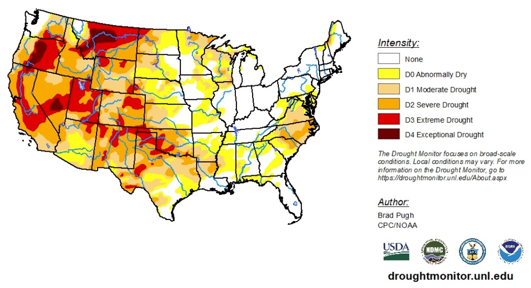
 According to the latest U.S. Drought Monitor report, a persistent pattern over the North Pacific and western North America maintained a continuation of frequent storms affecting the West Coast through late Dec. 7-day precipitation from Dec. 21 - 27 exceeded 2 inches across much of Calif. along with western portions of Ore. and Wash. Dry weather with much above normal temperatures persisted throughout the central and southern Great Plains. As of Dec. 28, month-to-date temperatures have averaged more than 7 degrees F above normal across the south-central U.S. Eastern N.D.
With data ranging from Dec. 22 to Dec. 28, 2021, persistent dryness, periods of enhanced winds and anomalous warmth this month, and worsening soil moisture conditions, a broad 1-category degradation was made to much of Oklahoma and the Texas Panhandle. Most locations across southwestern Okla. along with the Oklahoma and Texas Panhandles have received less than 0.10 inch of precipitation during the past 70 to 80 days. As of Dec. 28, Amarillo, Texas has observed no precipitation for 76 consecutive days which is the second-longest dry streak on record. Month-to-date temperatures, as of Dec. 28, have averaged more than 8 degrees F above normal throughout nearly all of Okla. and Texas.
In the High Plains, a continued expansion of abnormal dryness, moderate drought and severe drought were required again this week across much of Kansas due to worsening soil moisture indicators, 90 to 120-day SPIs, declining streamflows, and impacts such as cattle sell-offs. A 1-category degradation was made to the southwest corner of Nebraska based on soil moisture and SPI values at various time scales. A recent increase in snowpack led to improving drought conditions across the central Rockies, to the west of the Continental Divide. Severe to extreme (drought) was expanded across northeast Colorado due to declining soil moisture indicators and EDDI. Precipitation (more than 0.5-inch, liquid equivalent) on Dec. 26 along with positive SPI values dating back 6 months supported a slight decrease in abnormal dryness and moderate drought across central and eastern N.D.
In the West, during the past two weeks, precipitation has averaged 150 to 300% of normal, or more, throughout nearly all of Calif. This wet pattern during mid to late Dec. has also been accompanied by below-normal temperatures (-2 to -6 degrees F) across Calif. and the Pacific Northwest. Periods of heavy snow continue to build a favorable snowpack from the Cascades southward to the Sierra Nevada Mountains. On Dec. 23 and 24, a strong low-pressure system tracked inland from the East Pacific and resulted in widespread precipitation of 0.5 to 3 inches, liquid equivalent, across much of southern Calif. along with the Great Basin, Southwest, and Four Corners region.
To view the Contiguous U.S. Drought Map, click here.
Looking ahead, another round of heavy rain and high-elevation snow is forecast across southern California, the Southwest, and Four Corners region on Dec 30 and 31. A low-pressure system and trailing front are expected to progress eastward from the central to the eastern U.S. from Jan 1 to 2. A swath of snow may occur on the northwest side of the surface low track, from the central Plains northeast to the Midwest and Great Lakes. Little to no precipitation is expected for the southern Great Plains into the beginning of the New Year. Heavy rain and high-elevation snow is forecast to return to the Pacific Northwest and northern California by Jan 3. Following a brief moderation in temperatures, another outbreak of Arctic air is anticipated to shift south from Canada into the northern Plains during the first week of January 2022. The wet pattern is likely to persist across Hawaii well into the New Year.
To view the 6 - 10 Day Precipitation Outlook, click here.
To view the 6 - 10 Day Temperature Outlook, click here.
According to the Monthly Drought Outlook map, the only improvements or removal of drought conditions are expected in the Pacific Northwest, bleeding into western Montana and western Wyoming. Other than that, drought conditions are expected to persist in the West and areas of the Great Plains where it continues to develop.
To view the Monthly Drought Outlook map, click here.
Oklahoma
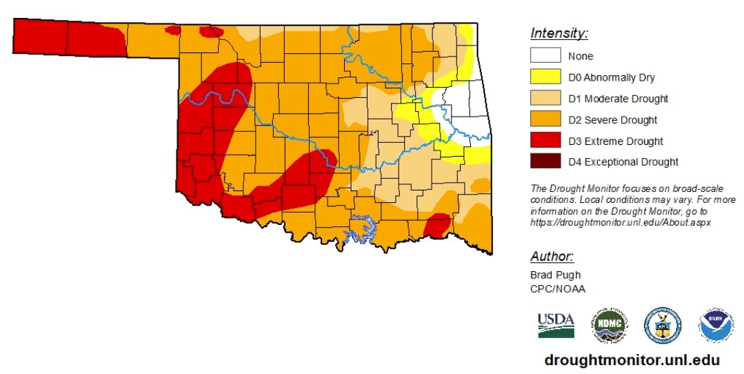
According to data from Dec. 22 to Dec. 28, 2021, drought conditions have rapidly deteriorated in Oklahoma. Although abnormally dry conditions or worse increased just 5%, extreme drought conditions nearly tripled. As of Dec. 28, 2021, 22.6% of the state is experiencing extreme drought conditions. The large increase in extreme drought conditions consumes much of western Oklahoma.
At the same time, severe drought conditions or worse expanded across the state, changing from 43.6% to 72.5%. Moderate drought conditions or worse changed from 79.1% to 90.1%
A small pocket of eastern Oklahoma continues to fight off drought conditions.
The 6-to-10-day precipitation outlook map shows Oklahoma is likely to receive below-normal precipitation levels. The 6-to-10-day temperature outlook map shows normal to lower-than-normal temperatures are expected.
To view the Oklahoma drought map, click here.
WebReadyTM Powered by WireReady® NSI
Top Agricultural News
More Headlines...


