Agricultural News
Oklahoma Facing Worst Drought Conditions in Recent Years
Thu, 20 Jan 2022 13:53:01 CST
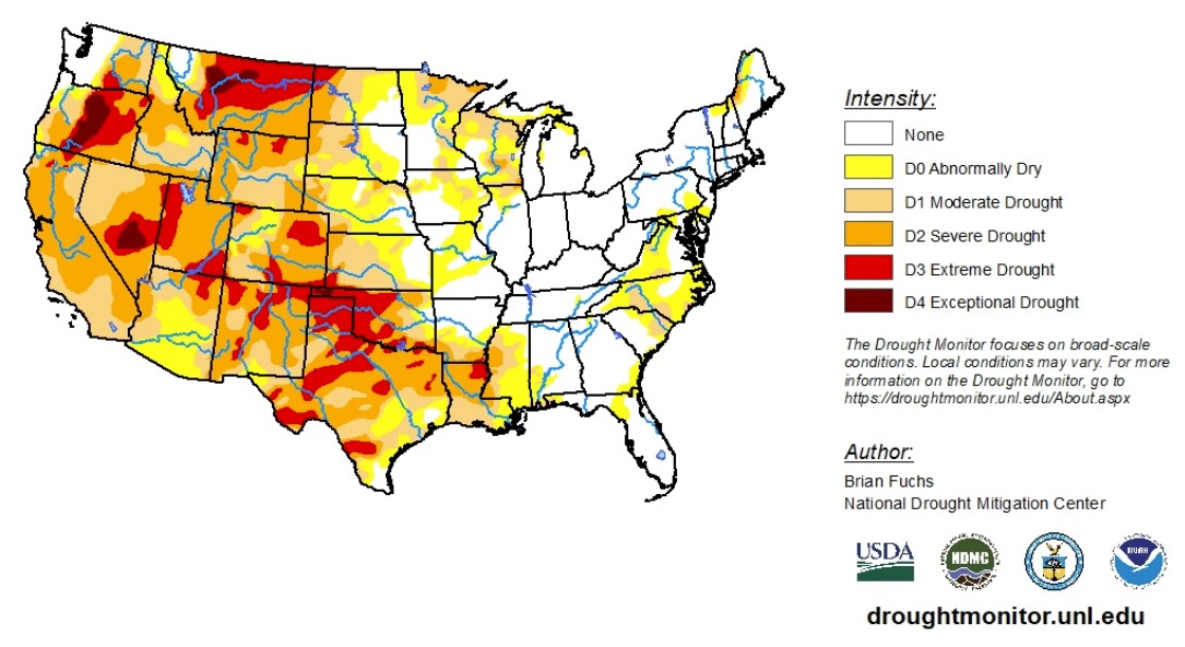
 According to the latest U.S. Drought Monitor report, a winter storm impacted the High Plains to the Midwest. For many areas, this was the first time heavy snow occurred this season. West of the Missouri River there was very little precipitation for the week. Temperatures were highest over the northern Rocky Mountains and Great Plains.
In the southern Plains, temperatures were near normal to slightly above. Coastal areas of Texas, into the Delta, were 2 to 4 degrees below normal. Degradation continued as most areas have been dry since the fall and temperatures have remained well above normal during this period. In Oklahoma, a new area of exceptional drought was added in the panhandle while extreme drought conditions expanded eastward. Severe and extreme drought conditions expanded in the central and northern portions of Texas while moderate and severe drought conditions expanded in south Texas. There was an improvement to moderate drought and abnormally dry conditions in east Texas.
In the High Plains, higher-than-normal temperatures dominated, with areas of the Dakotas recording temperatures that were 10 to 15 degrees above normal. The winter storm brought snow to much of North Dakota, eastern South Dakota and eastern Nebraska. Much of the rest of the area recorded below-normal precipitation for the week. With an ongoing "snow drought" in portions of the western Dakotas, degradation was shown this week in the Black Hills of South Dakota where moderate drought conditions expanded and in western North Dakota where severe drought conditions expanded. Some improvements were made to areas of extreme drought in southeast Wyoming, western Nebraska and central Colorado.
In the West, temperatures were near normal for most of the region with some areas of Wyoming and Montana recording temperatures 10 to 15 degrees above normal. With most of the region recording little to no precipitation for the week, most changes were based on an assessment of the last several weeks. Improvements were made to extreme and exceptional drought conditions in western Montana, eastern Idaho and northwest Wyoming.
To view the Contiguous U.S. Drought Map, click here.
Looking ahead to Jan. 23 to 25, higher-than-normal temperatures in the West and northern Rocky Mountains could be observed. Some precipitation is expected over the Pacific Northwest and into the Rocky Mountains. The wettest locations are expected to be in the South and Southeast, into the Mid-Atlantic where up to an inch or more of precipitation could be expected.
Jan. 25 to 29 outlooks show a high probability of lower-than-normal temperatures in the eastern half of the country. It is anticipated that below-normal precipitation will impact much of the country centered in the Great Basin and the Midwest. There are high chances for above-normal precipitation in the Rocky Mountains and along the Gulf Coast.
To view the 6 - 10 Day Precipitation Outlook, click here.
To view the 6 - 10 Day Temperature Outlook, click here.
According to the Monthly Drought Outlook map, drought conditions should continue to improve from the Pacific Northwest, down into northern California and eastward to western Wyoming, Montana and northern Utah. Drought conditions are also expected to release California's southern coast and southern Arizona and a small part of southern New Mexico. In the rest of the West and Great Plains, drought conditions are expected to persist and further develop - especially in Texas.
To view the Monthly Drought Outlook map, click here.
Oklahoma
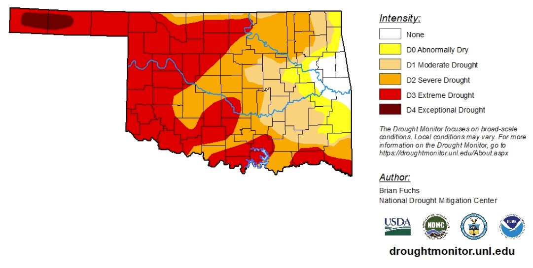
With data ranging between Jan. 12 to 18, drought conditions have degraded after taking a brief pause. Since Christmas, extreme drought conditions quickly swept through the state. For the first time since the summer of 2018, exceptional drought conditions have been recorded in Oklahoma. The exceptional conditions have developed in the Panhandle, in Texas and Cimarron Counties and account for 2% of drought conditions in the state. The Panhandle has faced abnormally dry conditions or worse since June 2021. According to the Mesonet, the Panhandle has not received less than 3 inches of rain in the last four months.
Right now, 95% of the state is experiencing abnormally dry conditions or worse. Moderate drought conditions have decreased as overall drought conditions deteriorate, accounting for just 14% of the state. Severe drought conditions account for 27% of abnormally dry conditions or worse. Extreme drought conditions have increased from 41% to 44% and dominated the western half of Oklahoma.
A small pocket of eastern Oklahoma continues to fight off abnormally dry conditions or worse.
The 6-to-10-day precipitation outlook map shows most of Oklahoma is likely to receive normal precipitation levels for this time of year. The Panhandle could receive higher-than-normal precipitation levels for this time of year. The 6-to-10-day temperature outlook map shows lower-than-normal temperatures are likely.
To view the Oklahoma drought map, click here.

WebReadyTM Powered by WireReady® NSI
Top Agricultural News
More Headlines...


