


Agricultural News
Latest Drought Monitor Improves Slightly Across State
Thu, 14 Apr 2022 14:16:13 CDT
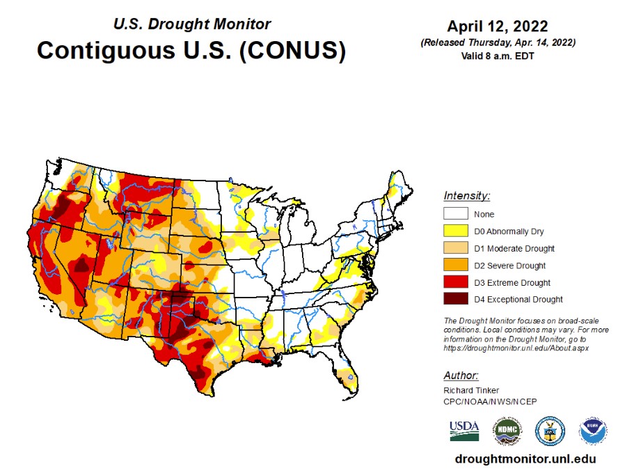
 According to the latest U.S. Drought Monitor report, a series of storms dropped moderate to heavy precipitation on much of the eastern half of the country, with 3 to locally 6 inches of rain falling on a swath from central Alabama to central South Carolina, near the Mississippi and Ohio Rivers confluence, areas from the Delmarva Peninsula to southeastern New York state, and portions of the Cascades and coastal areas in Washington and portions of Oregon. Temperatures did not average far from normal except in the southwestern and northeastern parts of the country. The Southwest, The Great Basin, most of California, and New England experienced temperatures up to 5 deg. F in spots. In addition, episodes of low humidity and strong winds worsened dryness across much of the Plains and adjacent Rockies.
In the Southern Plains, only limited areas recorded light to moderate precipitation, with most sites reporting little or none. Between 2 and 4 inches fell on small areas in northeastern Oklahoma, northeastern Arkansas, and northwestern Tennessee. Most other areas of northern Tennessee observed 1.5 to 2.5 inches, and similar amounts fell on much of northern Arkansas and parts of eastern Louisiana. Several tenths of an inch were measured in the rest of Tennessee and central Louisiana, but a majority of the Region - including almost all of Texas and Oklahoma - experienced a precipitation-free week. In general, dryness and drought worsens moving from northeast to southwest across the South Region. Eastern Oklahoma, central and northern Arkansas, and almost all of Tennessee are free of significant dryness. In sharp contrast, D2 to D4 drought covers southern Louisiana, most of the western half of Oklahoma, and the central and eastern reaches of Texas. Exceptional drought (D4) covers several sizeable areas in the western half of Texas and the Oklahoma Panhandle. Only a few tenths of an inch of precipitation has fallen at best since early February across central and south-central Texas, with 17 sites reporting rainfall totals among the driest 2 percent of the historical distribution for the period, as did a few sites in northwestern Texas outside the Panhandle. For the past half-year as a whole, less than 10 percent of normal precipitation has been observed in part of west-central Texas, including much of the Big Bend, while less than 25 percent of normal fell on most of the western half of Texas and the Oklahoma Panhandle. In addition, episodes of low humidity and strong winds worsened the situation across the already-parched region, leading to high wildfire danger and areas of blowing dust.
In the High Plains, an inch or two of precipitation fell on northwestern South Dakota, a small part of eastern North Dakota, and the highest elevations of north-central Colorado. Elsewhere, a few areas of 0.5 to 1.0 inch was observed in parts of the central and southern Dakotas, northwestern Nebraska, and several swaths scattered across Wyoming. A few tenths of an inch, at best, fell elsewhere. Dryness and drought cover a large majority of the High Plains Region; only the east-central and northeastern Dakotas and eastern Kansas are free of any significant dryness. D2 to D3 cover central and western parts of the Region, including all of Wyoming, Colorado, and most of Nebraska. Slow intensification and expansion has been noted across many areas over the past several months, and D3 expanded to cover additional portions of north-central Wyoming, central Nebraska, and an area near the western Kansas/Nebraska border. Elsewhere, few changes were introduced. Recently, strong winds and low humidity have made dryness more acute, especially in southern parts of the Region.
The West endured another dry week, with the heaviest precipitation falling along and west of the Cascades in Washington and northern Oregon (generally 1.5 to 3.5 inches, with isolated amounts reaching 6 inches in the highest elevations). This is one of two areas free of dryness and drought (northwestern Montana and adjacent Idaho is the other). D2 and D3 cover a large majority of the West Region, and exceptional drought (D4) has become entrenched in the Oregon Cascades, south-central Nevada, parts of southern New Mexico, and northeastern New Mexico. Slow worsening and expansion continued, with noticeable deterioration in parts of New Mexico, Nevada, and California this week. Water storage in the two largest reservoirs in the west - Lake Powell along the central Arizona/Utah border, and Lake Mead farther downstream along the Colorado River - has dropped to unprecedented levels. In early April, the combined storage was only 44 percent of the average since 1964, and less than 75 percent of the storage in Lake Mead alone just before Lake Powell started to fill.
To view the Contiguous U.S. Drought Map, Click Here
Looking ahead to April 14-18, the storm system bringing blizzard conditions to the northern Plains will be moving out, followed by a late-season outbreak of Arctic air. Unseasonably low temperatures will push through much of the Nation during April 14 - 18, 2022. Daytime maximum temperatures will average at least 3 deg. F below normal everywhere outside the Atlantic Seaboard and the southern tier of the country from the Southeast to the desert Southwest. In the northern Plains and adjacent areas, daytime highs are expected to average 18 to 25 deg. F below normal. In contrast, highs should average 3 or more deg. F above normal from most of Texas through the Four Corners Region and parts of Nevada. The greatest departures from normal will be in the southern High Plains and lower Rio Grande Valley (+5 to +10 deg. F). Heavy precipitation (2 to 4 inches and locally more in higher elevations) is expected across central and southern parts of Mississippi and Alabama, southeastern North Carolina, upper New England, and the coastal and elevated parts of the Northwest from central Virginia to the Canadian Border. Moderate amounts (0.5 to 2.0 inches) should pelt the rest of the Pacific Northwest, most of the Southeast and the lower Mississippi Valley, most of the coastal Carolinas, southern New England and the adjacent Northeast, the northern Great Lakes Region, and the higher elevations of the northern Rockies. Meanwhile, light precipitation at best is expected across the southwestern quarter of the country, the central and eastern Plains, the upper Mississippi and Ohio Valleys, the Appalachians, and the middle Atlantic region.
The ensuing 5 days (April 19 - 23) should see below-normal temperatures lingering across the northern Great Plains and most locations from the Mississippi Valley to the Atlantic Coast. The northern Intermountain West, Pacific Northwest, and northern two-thirds of California are also expected to average colder than normal. Meanwhile, odds favor warmer than normal conditions across most of the Plains, Rockies, Great Basin, and Southwest. New Mexico, eastern Colorado, and adjacent areas have the best odds for above-normal temperatures. Above-normal precipitation is expected in New England, southwestern Texas and adjacent New Mexico, the upper Mississippi Valley, the northern Plains, and most places in and west of the Rockies outside the Southwest. Meanwhile, there are enhanced chances for subnormal precipitation from the central and southeastern Plains eastward through the Ohio Valley, much of the Mississippi Valley, the Appalachians, the Southeast, and the middle Atlantic region.
To view the 6 - 10 Day Precipitation Outlook, click here.
To view the 6 - 10 Day Temperature Outlook, click here.
To view the Monthly Drought Outlook map, click here.
Oklahoma:
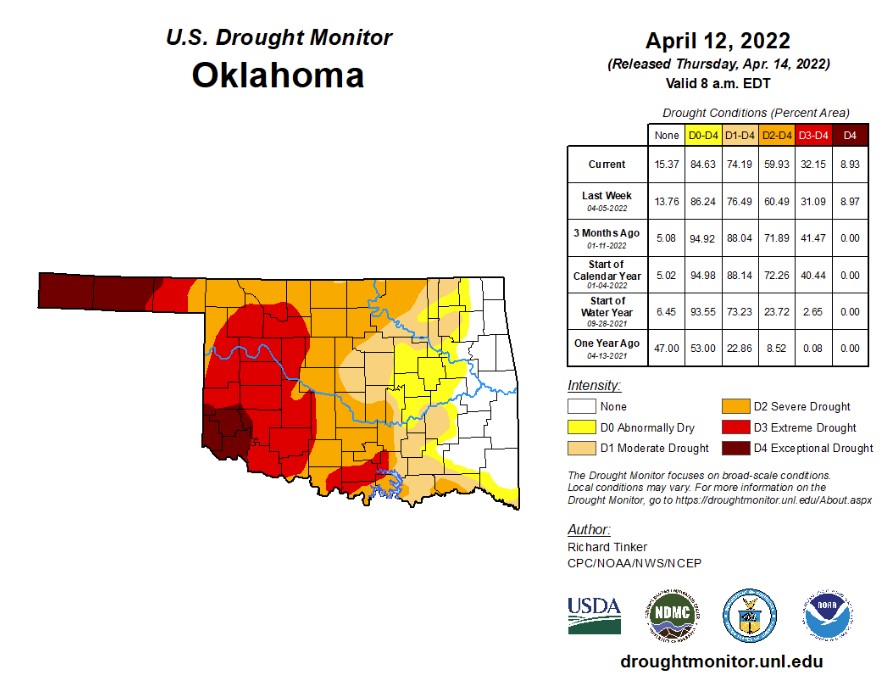
In Oklahoma 2,821,497 people are affected by drought. Exceptional drought is 8.9% with Cimarron, Texas, Beckham, Greer, Kiowa, Harmon, and Jackson counties in exceptional drought. (Last week this number was at 9.0%, and last month, 14.4%) 32.2% of the state is in extreme drought this week. Just a slight increase from last week, which was 31.1%. 74.2% of the state is in moderate drought or worse (down from last week at 76.5%). 84.6% of the state is abnormally dry or worse (down from 86.2% last week). We currently have 28 counties with USDA disaster designations, and this is the 56th driest year to date over the past 128 years. Watch for gusts back up into the 30-40 mph range out west to create yet another couple of days of fire danger. the 7-day period ending on April 11, 2022, ranked as the second windiest 7-day period since 2006 at 26.4 mph. The drought continues to shrink across eastern Oklahoma, but unfortunately, intensify across western OK. Several changes of rain are coming up for relief in eastern Oklahoma, but not so much for western Oklahoma.
The 6-10 day precipitation outlook map shows Oklahoma has a 30-40% change of rain with warmer weather.
To view the Oklahoma drought map, click here.
WebReadyTM Powered by WireReady® NSI
Top Agricultural News
More Headlines...


