


Agricultural News
Latest Drought Monitor Shows Drought in Western Oklahoma Continues to Intensify
Thu, 21 Apr 2022 13:06:10 CDT
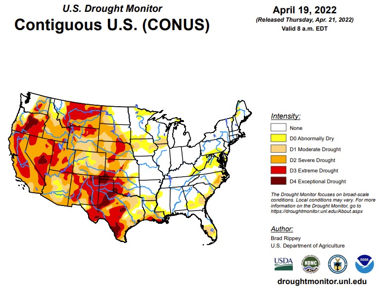
 According to the latest U.S. Drought Monitor report, the drought-monitoring period, which began on the morning of April 12 and ended early April 19, featured a powerful spring storm delivering significant, late-season snow from the Cascades and Sierra Nevada to the northern Plains. High winds and blizzard conditions accompanied the snow, especially across the northern Plains. Farther south, drought conditions worsened across portions of the central and southern Plains and the Southwest, amid windy, dry conditions. At times, winds raised dust and contributed to the rapid spread of several wildfires, including the 6,159-acre McBride Fire, which destroyed well over 300 structures after being ignited on April 12 in Ruidoso, New Mexico. Meanwhile, heavy showers and locally severe thunderstorms swept across the Mississippi Delta and environs, producing widespread rainfall totals of 2 to 4 inches or more and causing localized wind and hail damage. Significant rain fell in other areas, including parts of the Midwest and Northeast. During the last 24 hours of the drought-monitoring period, rain swept into the Atlantic Coast States, with some wet snow observed across the interior Northeast. Warm weather prevailed for much of the period in the South and East, while a harsh cold snap engulfed the northern Plains and Northwest. In fact, an extended spell of chilly weather broadly covered the western U.S., as well as the upper Midwest.
In the Southern Plains, heavy rain fell across roughly the eastern half of the region, resulting in extensive reductions in the coverage of abnormal dryness (D0) and moderate to extreme drought (D1 to D4). According to a network of volunteer (CoCoRaHS) observers, month-to-date rainfall totals of 6 to 8 inches or more are common across the region. April 1-19 rainfall officially reached 8.51 inches in Arkadelphia, Arkansas; 7.64 inches in Hattiesburg, Mississippi; and 6.70 inches in Troy, Alabama. In stark contrast, moderate to exceptional drought (D1 to D4) continued to worsen in many areas west of a line stretching across eastern sections of Oklahoma and Texas. On April 17, Texas led the U.S. (tied with Montana) with topsoil moisture rated 85% very short to short, according to the U.S. Department of Agriculture. Also, on the 17th, more than three-quarters (81%) of the winter wheat in Texas, along with 80% of the oats and 76% of the rangeland and pastures, were rated in very poor to poor condition. Nationally, 37% of the winter wheat was rated in very poor to poor condition on that date, highest at this time of year since April 14, 1996, when 43% of the crop fell into those two categories. On the southern High Plains, episodes of blowing dust or smoky skies have been common this spring; in Lubbock, Texas, visibilities were sharply reduced in dust on April 12, when a southwesterly wind gust to 60 mph was reported. The south-central U.S. has also experienced periods of extreme heat, with McAllen, Texas, reporting highs of 100°F or greater on April 6, 11, and 13. McAllen's high of 109°F on April 6 set a monthly record (previously, 107°F on April 26, 1984, and April 27, 2014). However, there have also been cool spells, with Dalhart, Texas, posting a daily-record low of 22°F on April 14.
In the High Plains, a winter-like storm pounded North Dakota and portions of neighboring states, delivering much-needed moisture but disrupting travel and stressing livestock. Across the remainder of the High Plains, however, windy, dry weather raised dust, resulted in fast-spreading wildfires, and led to a broad increase in the coverage of abnormal dryness (D0) and moderate to extreme drought (D1 to D3). In North Dakota, April 12-14 snowfall included 12.6 inches in Grand Forks (National Weather Service office) and 18.3 inches in Bismarck. Storm-total snowfall topped 2 feet in several North Dakota communities, including Velva (28.0 inches), Lansford (27.5 inches), Dunn Center (26.0 inches), and Underwood (24.3 inches). During the storm, a wind gust to 54 mph was clocked in Bismarck; elsewhere in North Dakota, gusts reached 60 mph in Dickinson and 63 mph in Minot and Hettinger. In the storm's wake, single-digit low temperatures were common across snow-covered North Dakota, where temperatures fell to 8°F in Minot and Grand Forks. With a low of 0°F on the 16th, Bismarck, North Dakota, experienced its latest-ever reading of 0°F or below-and its coldest April weather since 1996, when it was -1°F on April 5. Temperatures briefly plunged across the central Plains, threatening the already drought-stressed winter wheat crop. Denver, Colorado, registered 10°F on April 13, a record for the date, followed the next day by daily-record lows of 4°F in Sidney, Nebraska, and 9°F in Colby, Kansas. By April 17, the U.S. Department of Agriculture reported that topsoil moisture was rated more than 60% very short to short in each of the region's states except North Dakota, led by Nebraska (84% very short to short). On the same date, nearly half (48%) of the winter wheat in Colorado was rated in very poor to poor condition. One-fifth to one-third of the wheat was rated very poor to poor in Kansas (31%), Nebraska (27%), and South Dakota (22%).
In the West, a classic La Niña regime has developed in recent weeks, providing beneficial moisture across northern California and the Pacific Northwest, eastward to the northern Rockies. At the same time, dry, often windy weather has affected the nation's southwestern quadrant. As a result, deterioration has been observed in parts of the Southwest, particularly in New Mexico. According to the U.S. Department of Agriculture, Montana (85%) led the West in topsoil moisture rated very short to short on April 17, followed by New Mexico (80%). New Mexico, in addition to the McBride Fire, has been dealing with several other blazes, including the 7,573-acre Hermits Peak Fire, which started as a prescribed fire northwest of Las Vegas on April 6 before escaping containment. More recently, the Crooks Fire has been actively burning south of Prescott, Arizona, with numerous evacuations in effect. Farther north, however, the recent spell of cool, damp weather has generally boosted topsoil moisture, has locally improved water-supply prospects, and has provided a late-season boost in high-elevation snowpack. Snow briefly fell at lower elevations, too, with the airport in Portland, Oregon-which had never experienced a measurable April snowfall-receiving 1.9 inches on April 11-12. The airport's previous latest snow had fallen on March 25, 1965, when 0.3 inch fell. Downtown Portland, hit with 2.0 inches of wet snow on April 11, also set a record for its latest accumulation (previously, 0.1 inch on April 10, 1903). Measurable snow fell in Great Falls, Montana, each day from April 11-17, totaling 12.2 inches. Farther west, the first-ever measurable April snow fell at the agricultural experiment station in Wenatchee, Washington. Incredibly, the Wenatchee Experiment Station received 10.4 inches of snow on April 14, boosting its month-to-date total to 13.1 inches. A neighboring station, the Wenatchee Water Plant, received a storm total of 5.4 inches, breaking its April 1935 record of 0.5 inch. The net effect of the Northwestern precipitation was to result in slight trimming of moderate to extreme drought (D1 to D3). However, there was often a fine line between areas that received beneficial precipitation and those that did not.
To view the Contiguous U.S. Drought Map, Click Here.
Looking ahead to April 21-25, a parade of Pacific storms will maintain unsettled weather across much of the country during the next several days. One of the most consequential storms will traverse the western U.S. on April 21-22 before intensifying over the northern and central Plains. The storm system will result in similar impacts to those observed last week, including wind-driven snow across northern sections of the Rockies and Plains (mostly on April 22-23); high winds, possible blowing dust, and an elevated wildfire threat over a multi-day period across portions of the central and southern Plains and the Southwest; and a multi-day risk of severe thunderstorms, especially during the weekend from the Plains into parts of the mid-South and Midwest. In contrast, negligible precipitation will fall during the next 5 days along the Gulf Coast, in the Atlantic Coast States, and across the Southwest. The NWS 6- to 10-day outlook for April 26 - 30 calls for near- or below-normal temperatures across much of the country, with the greatest likelihood of cool conditions focused on the Great Lakes States. However, warmer-than-normal weather will prevail from southern California to the central and southern Great Plains. Meanwhile, near- or below-normal precipitation should be observed nationwide, except for wetter-than-normal conditions from the northern Cascades to western North Dakota.
To view the 6 - 10 Day Precipitation Outlook, Click Here.
To view the 6 - 10 Day Temperature Outlook, Click Here.
To view the Monthly Drought Outlook map, Click Here.
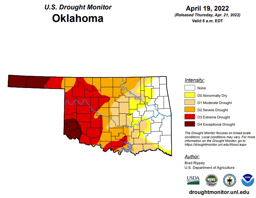
OKLAHOMA:
In Oklahoma, 2,693,682 people are affected by drought. Exceptional drought is 9.4% with Cimarron, Texas, Beaver, Beckham, Kiowa, Greer, Harmon, Jackson, and Tillman counties in exceptional drought (last week, this number was at 8.9% and last month was 7.8%). 36% of the state is in an extreme drought this week, which is an increase from last week at 32.2%. 57.6% of the state is in severe drought (last week was 59.9%). 72.7% of the state is in moderate drought or worse, down from last week at 74.2%. Also down from last week is parts of the state that are abnormally dry or worse at 80.8% (last week was 84.6% and last month was 87.1%). We currently have 66 counties with USDA disaster designations, and this is the 56th driest year to date over the past 128 years. In western parts of the state, dry counties are still waiting on rain, with part of the Oklahoma Panhandle experiencing 200 days and counting with less than .25 inches of rainfall. Along with the drought, heavy wind and high temperatures are not helping moisture retention. There are some storm chances coming up across the northwest corner of Oklahoma along with severe wind and hail chances.
The 6-19 precipitation outlook map shows Oklahoma has a below-normal percent chance of rain at 33-40% or below with warmer temperatures as we enter next week.
To view the Oklahoma drought map, click here.
WebReadyTM Powered by WireReady® NSI
Top Agricultural News
More Headlines...


