

Agricultural News
Exceptional Drought Increases Across the State with a Chance of Storms in the Forecast
Thu, 28 Apr 2022 10:31:26 CDT
 Only about 10 days after a powerful, winter-like storm struck the northern Plains, a similar system delivered another round of heavy precipitation and high winds. With the more recent storm, which primarily unfolded on April 22-23, heavy snow was focused across a smaller area, primarily blanketing western North Dakota, southeastern Montana, northwestern South Dakota, and portions of Wyoming. Meanwhile in the Red River Valley, heavy rain falling on partially frozen soils resulted in extensive flooding, especially north of Fargo, North Dakota, with runoff further enhanced by melting snow. Farther south, high winds again raked the central and southern Plains and the Southwest, resulting in blowing dust and fast-spreading wildfires. Across the southern High Plains' hardest-hit drought areas, hot, windy weather sapped any remaining soil moisture and further stressed rangeland, pastures, and winter grains. Meanwhile, a few severe thunderstorms dotted the Plains and upper Midwest, leading to localized wind and hail damage. The greatest concentration of severe weather occurred on April 22 from South Dakota to northern Texas. In contrast, little or no precipitation fell during the week across the nation's southwestern quadrant, leading to further drought intensification. As the drought-monitoring period ended (on the morning of April 26), a significant rain event was winding down across parts of southern and eastern Texas.
In the Southern Plains
The region remained split between critically dry conditions on the High Plains of Oklahoma and Texas and wet conditions just to the east. During the drought-monitoring period, the axis of heaviest rain stretched from northeastern Texas into northern Arkansas, with additional rainfall maxima in parts of southern and eastern Texas. Those rains led to targeted, one-category improvements in the drought depiction, with highly localized two-category changes. Meanwhile, the region's driest areas continued to experience deteriorating conditions, including a broad expansion of exceptional drought (D4), amid periods of extreme heat, high winds, and blowing dust. Temperatures reached 100°F mainly on April 20 and 21 in parts of the south-central U.S., extending to the Texas-Oklahoma border near Childress (100°F on April 21) and Wichita Falls, Texas (99°F on April 20). In western Texas, peak gusts April 22 were clocked to 73 mph in Lubbock and Dalhart. On April 24, Texas led the country in several drought-related categories, according to the U.S. Department of Agriculture, including topsoil moisture rated very short to short (86%, tied with New Mexico) and winter wheat rated in very poor to poor condition (78%). On the same date, nearly half (48%) of Oklahoma's wheat was rated very poor to poor.
In the High Plains
For the second week in a row, significant precipitation fell across parts of the northern Plains. Heavy snow blanketed western North Dakota, southeastern Montana, northwestern South Dakota, and parts of Wyoming, helping to further improve soil moisture. Still, by April 24, the U.S. Department of Agriculture reported topsoil moisture was rated at least one-half very short to short in each of the region's states except North Dakota (26% very short to short, down from 39% the previous week). Elsewhere in the region, topsoil moisture rated very short to short ranged from 53% in South Dakota to 82% in Nebraska. Still, parts of the eastern Dakotas have become very wet, with runoff enhanced by melting snow and rain falling on partially frozen soils. Following the latest storm, moderate to major flooding developed in the Red River Valley, extending northward from near Grand Forks, North Dakota. By April 27, the Red River at Oslo, Minnesota, was more than 11.5 feet above flood stage and less 10 inches below the April 2009 high-water mark. Farther south, however, drought continued to gradually expand and intensity, amid windy, mostly dry conditions and rapid temperature fluctuations. In Nebraska, daily-record highs for April 22 soared to 91°F in Sidney and 97°F in Valentine and North Platte, followed just 3 days later by a daily-record low of 14°F in Sidney. By April 24, more than one-quarter of the winter wheat in each of the region's major production states was rated in very poor to poor condition, led by Colorado (47%) and Kansas (36%).
The West
Conditions were nearly identical those observed the previous week, with beneficial precipitation falling across the northern tier of the region and windy, dry weather dominating the Southwest. Given the Southwest's low humidity levels, high winds, and drought-cured vegetation, two active wildfires the Hermits Peak and Cooks Peak Fires charred more than 50,000 acres of vegetation apiece in northeastern New Mexico. Northeast of Flagstaff, Arizona, the Tunnel Fire ignited on April 17 scorched nearly 20,000 acres of vegetation and destroyed more than 50 structures. At times, impressively high winds raked the Southwest, raising dust and fanning flames. On April 22 in New Mexico, wind gusts in Gallup, Farmington, Las Vegas, and Raton were clocked to 70, 72, 73, and 80 mph, respectively. By April 24, according to the U.S. Department of Agriculture, New Mexico led the nation tied with Texas with topsoil moisture rated 86% very short to short. By the 26th, Tucson, Arizona, reported a daily-record high of 100°F only the fourteenth observance of triple-digit heat on record during April in that location. Tucson's only earlier readings of 100°F or higher occurred on April 19-21, 1989, and April 22-23, 2012. Deterioration was common across the Southwest, with extreme to exceptional drought (D3 to D4) broadly expanding in New Mexico and moderate to severe drought (D1 to D2) increasing in coverage across parts of Arizona and Colorado. Farther north, however, periods of precipitation continued from northern California and the Pacific Northwest to the northern Rockies. Changes in the Northwestern drought depiction, although fewer than those noted the previous week, were driven by factors such as improving water-supply prospects and increasing topsoil moisture. In Oregon, topsoil moisture rated very short to short improved from 47 to 36% during the week ending April 24.
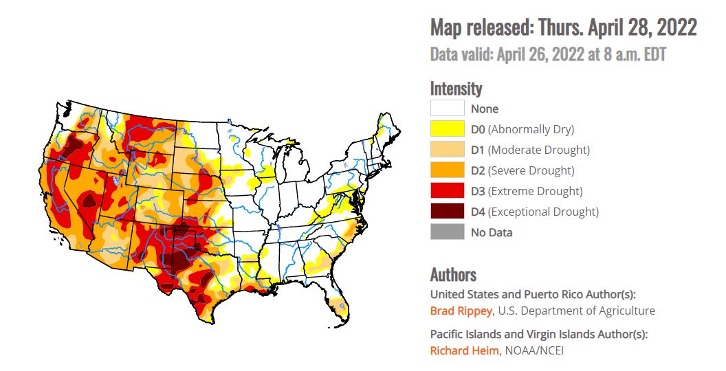
To view the Contiguous U.S. Drought Map, Click Here
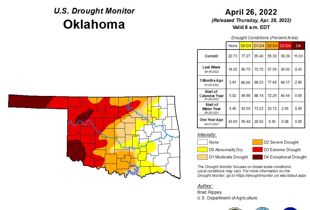
In Oklahoma
Currently 11.03% of the state is in Exceptional Drought compared to 9.43% last week. 39.49% is in Extreme drought compared to 36% a week ago. 55.30% is in Severe Drought, 65.40 is in Moderate drought, 77.27% is Abnormally drought, and 22.73% of the state shows no drought conditions. One year ago we had no counties in Oklahoma with Exceptional Drought, .08% in Extreme Drought, 6.30% in Severe Drought, 20.02% in Moderate drought, 56.40% of the state was abnormally dry and 43.60% had zero drought. Greer, Cimarron, Texas, Harmon, & Jackson counties are all in exceptional drought. Currently 2,693,682 people in Oklahoma are affected by drought. 66 counties with USDA disaster designations. And this is the 56th driest year to date was in 2022, over the past 128 years.
Last night and throughout the morning several areas of the State received rainfall. In Beaver they received 1.84 inches of rain which is more than they've recieved in the previous 196 days combined! According to State Climatologist Gary McManus additional rain chances over the next week or so will give us the opportunity to really relieve some of these drought areas across parts of western OK. Maybe not everybody, but increased relief does appear possible as we go through early next week. Despite the rain that fell across western OK last night, and possibly again today, tomorrow's storm system will once again bring a dryline into central OK. While that might fire off some big storms later tomorrow, it will also place western OK behind the dryline again with strong SW winds, plummeting humidity, summer temps, and that vegetation will not have greened up in a single day (and most folks missed on the rain anyway).
For Friday, April 29, 2022, Big hail will also be of particular concern now that it appears the cap will break after all. Of course, that could all change with the next outlook around noon, but things are trending a bit worse with heightened severe storm chances. Therefore, while some capping may limit storm coverage, it is anticipated that at least a few supercells will develop in a narrow corridor along the dryline by late afternoon/early evening. Very steep midlevel lapse rates and elongated hodographs above favorably-curved low-levels indicate significant hail potential with these storms, so be weather aware.
Looking Ahead:
The threat of frost and sub-freezing temperatures will linger at least into Friday in parts of the Great Lakes and Northeastern States. Meanwhile, a disorganized storm system will cross the western U.S. before intensifying on April 29-30 over the nation's mid-section. With the storm's path across the central Plains and upper Midwest, rainfall could reach 1 to 3 inches in the north-central U.S., with some of the highest amounts expected on Friday in the Dakotas. Meanwhile, windy, dry weather in the nation's southwestern quadrant will lead to additional drought and wildfire concerns. Late in the weekend, however, portions of the southern Plains may experience some drought relief.
The NWS 6- to 10-day outlook for May 3 7 calls for the likelihood of near- or below-normal temperatures across the North and Far West, while warmer-than-normal weather will prevail from the Four Corners States eastward to the middle and southern Atlantic Coast. Meanwhile, near- or above-normal precipitation across most of the country should contrast with drier-than-normal conditions in the upper Great Lakes region and parts of the Southwest.
To view the 6 - 10 Day Precipitation Outlook, click here.
To view the 6 - 10 Day Temperature Outlook, click here.
To view the Monthly Drought Outlook map, click here.
WebReadyTM Powered by WireReady® NSI
Top Agricultural News
More Headlines...


