Agricultural News
Oklahoma Drought Conditions Improve Only Slightly Since Last Week
Thu, 04 Aug 2022 16:59:48 CDT
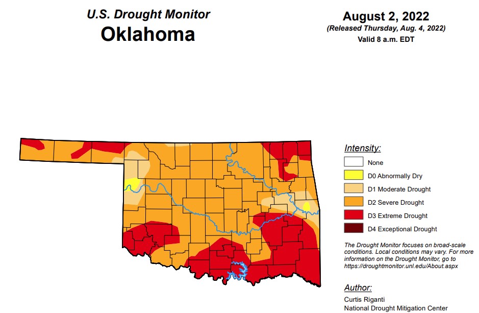
 With last week’s moisture, the possible worsening drought conditions in Oklahoma have been kept at bay, improving only slightly in this week’s report.
According to the latest drought monitor, in Oklahoma, exceptional drought remains at zero, the same as the last two weeks.
Extreme drought or worse is at 31.7 percent, up slightly from last week’s 37.4 percent.
Severe drought or worse has decreased slightly from last week’s 92.1 percent to this week’s 91.7 percent.
Moderate drought or worse has decreased slightly and is now at 99.1 percent, compared to last week’s 99.8 percent.
Abnormally dry or worse conditions remain at 100 percent, the same as the last two weeks.
The 6 to 10-day precipitation outlook map shows the majority of Oklahoma continues to lean below a 40 to 50 percent chance of precipitation through August 14th.
To view the Oklahoma Drought map, click here.
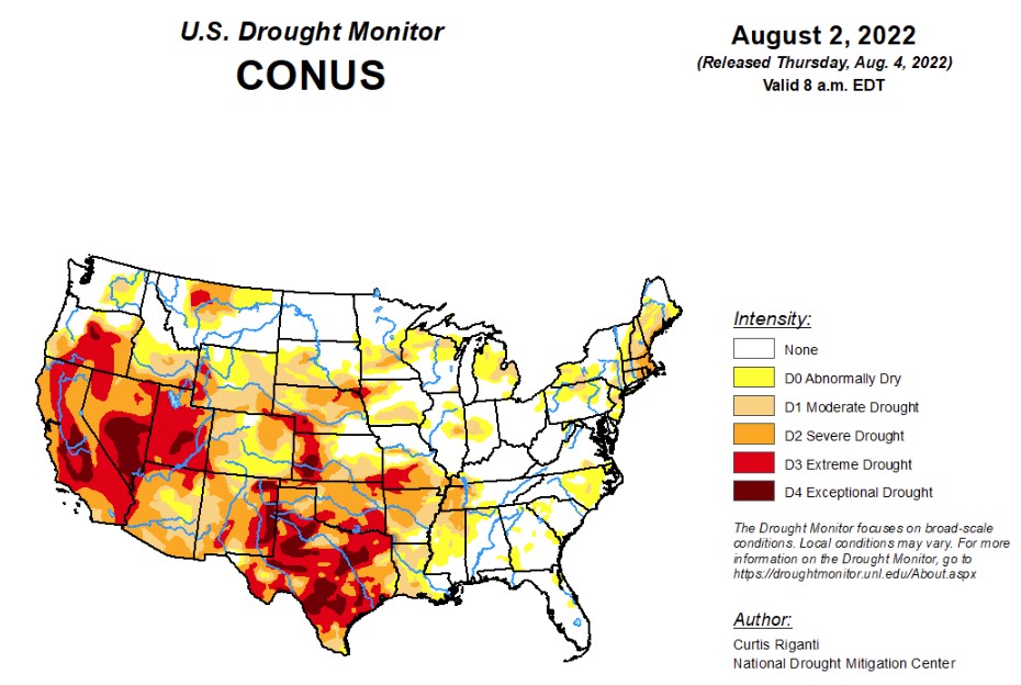
According to the latest U.S. Drought Monitor, weather and drought conditions varied widely in the contiguous U.S. this week. From the Desert Southwest and southern Colorado eastward into the Texas Panhandle, western Kansas, eastern Colorado, northern Oklahoma, and Arkansas, heavy rainfall fell in some areas, leading to localized improvements in ongoing drought. Drier conditions in the Northeast led to the expansion of moderate and severe drought in the New York City area and in parts of New England. Drier weather also led to expansion of drought conditions in parts of the central Great Plains and Upper Midwest. Similar conditions in Texas led to expansion of drought conditions there, while recent precipitation led to some improvements in southwest Texas. For more local details, please refer to the regional summaries below.
In the Southern Plains, the South region saw highly variable weather this week. This led to a wide range of changes to the ongoing drought areas across the region. Temperatures across most of Texas were above normal for the week, with many readings of 4-8 degrees above normal. Temperatures across the rest of the South were more moderate, generally within 4 degrees of normal on either side. Heavy rainfall occurred from the central and northern Texas Panhandle eastward through the northern half of Oklahoma, Arkansas, northern Mississippi, and portions of Tennessee. This led to improvements in the Texas Panhandle, northern Oklahoma, Arkansas, Tennessee, and Mississippi. Conditions also improved a bit in southwest Texas, where recent rainfall began to alleviate short- and long-term precipitation deficits. Meanwhile, short-term drying combined with above-normal temperatures to worsen drought conditions across some other parts of Texas and Oklahoma. Drought impacts across Texas ranged from crop failure to water supply problems, in one case from a well failure.
In the High Plains, moderate to heavy rains fell this week across portions of Colorado and western Kansas, related to an active North American Monsoon. Aside from other localized pockets of moderate to heavy rain, the High Plains region saw mostly dry weather this week. Temperatures from 2-4 degrees below normal were common across most of Kansas, southeast Colorado, central and eastern Nebraska, eastern South Dakota, and North Dakota this week. Near-normal temperatures mostly prevailed elsewhere, with parts of western Wyoming experiencing temperatures from 2-6 degrees above normal. The heavier rains in Colorado and western Kansas led to some improvements in ongoing drought, with localized removal of drought occurring, as precipitation deficits lessened. Conditions worsened in parts of southwestern, central, eastern, and northern Nebraska, and in adjacent southern South Dakota, where deficits in soil moisture and precipitation worsened. In Columbus, Nebraska, the Platte River ran dry, indicative of the moderate and severe drought conditions ongoing in and near the eastern Nebraska town. Two reservoirs in eastern Colorado are expected to run dry soon due to drought and water demand from irrigation.
In the West region, moderate to heavy rain fell across parts of Arizona, New Mexico, Utah, Nevada, and far southeast California. In locations where long-term rainfall deficits, soil moisture, and groundwater improved substantially, ongoing drought conditions improved locally. A south-to-north temperature gradient set up this week, with temperatures in Arizona and southern Nevada coming in 3-6 degrees below normal in spots, while a heat wave developed in the Pacific Northwest, pushing temperatures more than 9 degrees above normal in parts of northern California, Oregon, and Washington. In southeast and east-central Oregon, the evaporative stress from the heat locally worsened drought conditions. A myriad of drought impacts continued in the West this week, including wildfires in northern Utah and a central California reservoir dropping to its lowest level in 5 years.
To view the Contiguous U.S. Drought Map, click here.
From Thursday, August 4 to the evening of Monday, August 8, the National Weather Service Weather Prediction Center is forecasting moderate to heavy precipitation in parts of Arizona, western and northern New Mexico, high elevation areas of Colorado, northwest Wyoming, and localized areas of east-central California, central Nevada, and western and northern Utah. Widespread precipitation is also forecast in parts of the Upper Midwest, Middle Mississippi River Valley, Ohio River Valley, and southern Appalachians. Some precipitation is also forecast in western parts of the Northeast region, and along the Louisiana Gulf Coast.
For August 9-13, the National Weather Service Climate Prediction Center’s precipitation forecast favors above-normal precipitation near and west of the Continental Divide, especially in eastern Nevada and most of Utah. Farther east, below-normal precipitation is favored in the Central Great Plains and Upper Midwest. A narrow swath from southern Texas northeast to southern New England is slightly favored for above-normal precipitation. In Alaska, above-normal precipitation is favored in the east, while below-normal precipitation is favored in the southwest part of the state. Below-normal temperatures are strongly favored in most of Alaska, especially in west-central areas. Below-normal temperatures are slightly favored in most of Arizona, southern Nevada, and southeast California. Above-normal temperatures are favored across most of the Great Plains, Pacific Coast, and Northwest, especially from western Nebraska to the Dakotas and eastern Montana. Above-normal temperatures are also favored for most areas along the East Coast.
To view the 6 - 10 Day Precipitation Outlook map, click here.
To view the 6 - 10 Day Temperature Outlook map, click here.
To view the Monthly Drought Outlook map, click here.

WebReadyTM Powered by WireReady® NSI
Top Agricultural News
More Headlines...


