

Agricultural News
After Last Week's Improvements, Oklahoma Drought Conditions Decline Again
Thu, 11 Aug 2022 14:21:42 CDT
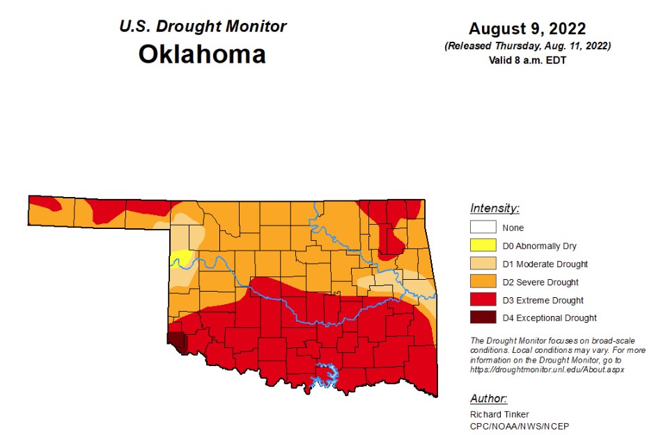 According to last week's drought monitor report, Oklahoma drought conditions showed slight improvements with percentages decreasing in the majority of drought categories. In this week's report, those conditions begin to decline once again as the state shows all the signs of flash drought.
According to the latest drought monitor, in Oklahoma, exceptional drought is now at .67 percent, after being at zero for several weeks.
Extreme drought or worse has increased to 48.8 percent, up from last week’s 31.7 percent.
Severe drought or worse has increased slightly to 92.4, up from last week’s 91.72.
Moderate drought or worse is now at 99.3 percent, up a bit from last week’s 99.1 percent.
Abnormally dry or worse conditions continue to be at 100 percent, the same as the last couple of weeks.
The 6-10 day precipitation outlook map shows Oklahoma is leaning above a 40-50 percent chance of rain through August 20th.
To view the Oklahoma drought map, click here.
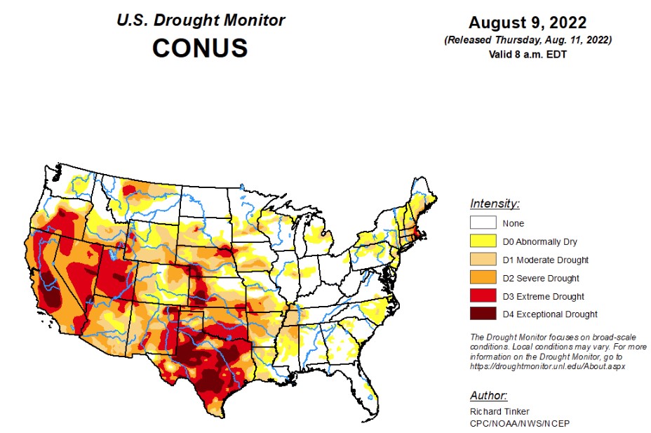
According to the lasted U.S. Drought Monitor Report, precipitation varied widely across the Lower 48 this week. Across the interior West, heavy monsoon rains set records in some locales, with tropical moisture streaming much farther north and west than normal (through southern Montana, the Great Basin, and parts of the Sonoran Desert). Death Valley, CA set an all-time record for 24-hour rainfall, being doused with 1.46 inches during August 5 and 6. The average annual rainfall in Death Valley is less than 2.5 inches, and the 24-hour total makes August 2022 the wettest month in Death Valley since February 2010, and more than half of all calendar years bring less rain than that 24-hour total.
Most areas from southern Missouri and northeastern Arkansas through central Illinois recorded over 1.5 inches of rain, as did parts of the Tennessee and southern Ohio Valleys, the Upper Midwest and western Great Lakes Region, the Central Gulf Coast, and northern Maine. In other areas from the Mississippi Valley eastward, heavy rain was less widespread. Still, numerous patches of land across the Upper Midwest, the middle Mississippi Valley, the Ohio Valley, and the Gulf Coast east of Texas received over 3.5 inches of rain, with isolated totals of 6 to locally 11 inches reported in a swath from the middle Mississippi and lower Ohio Valleys northward through the Upper Midwest and western Great Lakes Region. In contrast, many areas across these regions recorded only a few tenths of an inch of rain or less, with tight gradients between heavy rain and lesser amounts common. This variable rainfall pattern had a similar effect on areas of dryness and drought, with deterioration noted very close to improvement in many cases, and only a few broad swaths with a consistent pattern. Looking at the western half of the Lower 48, outside the areas affected by the monsoon, much drier conditions prevailed, though there were a few small areas recording moderate to heavy rainfall. Little or no rain fell on the central and southern Great Plains, much of the central Rockies, and the Far West. Temperatures averaged over 3 deg. F above normal in a large area across the central Rockies, most of the Plains, and the northeastern quarter of the country, exacerbating dryness in areas that missed the heavier rains.
In the Southern Plains, the eastern and western portions of this Region are trending in very different directions. Abundant rains have been falling on much of Tennessee, Arkansas, western Mississippi, most of Louisiana, and adjacent areas, where many areas of dryness and drought are improving. Over most of Oklahoma and Texas, however, rainfall has been scare of late, and with periods of excessive heat also affecting these areas, dryness is intensifying. In the last 2 weeks, over 3 inches of rain fell on most of Tennessee, northern Arkansas, and southern Louisiana. A few areas received over 4.5 inches of rain, with totals topping out at nearly a foot at one spot in northeastern Arkansas. Farther west, the have nots from central Oklahoma southward through most of Texas saw only several tenths of an inch, at best. From south of the Red River Valley through most of Texas to the Deep South regions, few areas saw any measurable rainfall. Conditions are not as dry in the Texas Panhandle, where enough rain fell (generally 2 to locally 5 inches) to provide some tangible relief from the recent dryness. Moisture shortages date back at least 6 months over most of Texas south of the Panhandle and north of Deep South Texas, extending across the entire breadth of the state. During the last 90 days, less than half of normal rainfall has been observed in most of these areas, with a few scattered patches getting less than 25 percent of normal. This equates to 3-month rainfall deficits of 5.5 inches or higher across most of central and eastern Texas, with parts of northeastern and southeastern Texas accumulating rainfall deficits of 7 to 10 inches. And for the last half-year, much of central and southeastern Texas racked up deficits of 11 to 16 inches. Not surprisingly, drought intensified or at best persisted across the south half of Oklahoma and most of Texas, most of the state is in extreme (D3) drought, with large swaths of D4 covering a good portion of the state from the Red River to Deep South Texas.
In the High Plains, most of the Great Plains recorded only a few tenths of an inch of rain at best last week, as did most of North Dakota. Rainfall was more abundant in central and southern Colorado, and in a swath across much of Wyoming and South Dakota. Totals of 0.5 to 2.0 inches were common in these areas, with isolated higher amounts of 2 to 5 inches soaking northwestern Wyoming, scattered areas in central and southern Colorado, and portions of central and eastern South Dakota. Fairly large areas of heavy rain were noted in south-central and parts of eastern South Dakota. Not surprisingly, parts of the wetter areas saw dryness ease somewhat while hot and dry conditions from eastern Wyoming and Nebraska southward promoted large areas of expansion and intensification there. In the last 60 days, much of this area received 35 to 65 percent of normal rainfall, but most locations recorded more. Periods of excessive heat have exacerbated the effects of the subnormal precipitation, and even some areas with near normal rainfall have seen conditions dry out due to the heat. Surface moisture shortages are now most acute in western Kansas and southwestern Nebraska, and a sizeable part of this area is in exceptional drought (D4), with the remainder in D3 along with northeastern Colorado, southeastern Kansas, northwestern Nebraska, and a newly-developed area in central South Dakota. Only the central and northern Dakotas, northeastern Kansas and adjacent areas, portions of the Colorado mountains, and part of central and northern Wyoming are largely devoid of drought, though abnormal dryness has been identified in some of those areas.
In the West, The North American Monsoon remained robust in early August. This is continuing to bring slow relief to a region long affected by entrenched drought. Tropical moisture from the monsoon circulation reached unusually far west this past week, into the southern Great Basin and southeastern California. As a result, exceptional amounts of rain fell on the southern half of Nevada and southeastern California, resulting in a very broad area of 1-category improvement. The record rains in Death Valley brought severe flash flooding that closed about 85 miles of road for several days, making many spots in the Valley unreachable. Farther east, rainfall was less remarkable, but still above normal, improving conditions across parts of New Mexico, southeastern Arizona, and parts of the southeastern quarter of Utah. Most locales in Arizona, New Mexico, the California deserts, southern Nevada, and a few other scattered areas have measured at least 200 percent of normal over the past 2 months. Portions of southeastern California, the Sonoran Desert, southwestern and northeastern Arizona, and a large area in northwestern New Mexico have been doused by 3 to 5 times normal rainfall. Farther north, central sections of Washington and Oregon also saw dryness and drought ease a little bit. The only area currently headed in the opposite direction is central and northern Montana. They are considerably wetter than normal for the past 60 days as a whole, but conditions have been changing rapidly since then. Rainfall has become scarce and temperatures have averaged well above normal. All this resulted in a significant expansion of D0 and D1 conditions into eastern and central Montana, although little change was noted in the areas already entrenched in severe to extreme drought.
To view the contiguous U.S. drought map, click here.
Looking ahead, above-normal temperatures - with the potential for excessive heat - should cover the central Plains, northern half of the Rockies, the Intermountain West (except where the monsoon is active), and the Pacific Northwest during August 11-15, 2022. The largest departures from normal are expected in the central Plains, the northern Rockies, and part of the northern Intermountain West averaging 4 to 8 deg. F above normal. In the western U.S., the only area expected to be somewhat cooler than normal are in the southern Rockies, Southwest, and Great Basin, where the robust monsoon will continue, keeping temperatures down. It should also be somewhat cooler than normal from the Mississippi River to the Appalachians, possibly spilling over into parts of the Atlantic Coastal Plain.
The Climate Prediction Center’s 6-10 day outlook (valid August 16-20, 2022) favors above-normal temperatures across a large part of the Lower 48 from the Great Basin and Southwest eastward through the lower Mississippi Valley, through almost all of the Appalachians and Eastern Seaboard. But wet weather is only weakly favored from the lower Mississippi River to the southern Atlantic States and across the Appalachians. Odds favor subnormal precipitation around the Great Lakes and across the northern tier of the Lower 48 from western North Dakota to the Pacific Coast.
To view the 6-10-day precipitation outlook map, click here.
To view the 6-10-day temperature outlook map, click here.
To view the monthly drought outlook map, click here.
WebReadyTM Powered by WireReady® NSI
Top Agricultural News
More Headlines...

