

Agricultural News
Oklahoma Drought Levels Rise in All Categories This Week, But Chance of Rain In Forecast
Thu, 06 Oct 2022 13:54:36 CDT
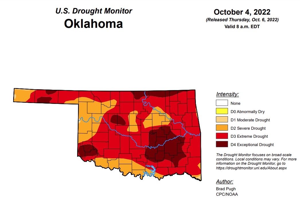 According to the Oklahoma Mesonet, 76% of the state is in Extreme/Exceptional (D3/D4) drought on the Drought Monitor, which is territory not seen in the state since early February 2013. Through the next seven days, there is a chance of precipitation throughout the state.
In Oklahoma, exceptional drought is at 17.78 percent, up slightly from last week’s 17.25 percent.
Extreme drought or worse is now at 75.7 percent, up from last week’s 64.5 percent.
Severe drought or worse has reached 99.5 percent, up from last week’s 94.4 percent.
Moderate drought or worse it up to 99.9 percent, up slightly from last week’s 99.8 percent.
Abnormally dry or worse remains the same as last week at 100 percent.
According to the 6-10-day precipitation outlook map for Oklahoma, the majority of the state is leaning above a 40 to 50 percent chance of precipitation through October 15, with the southern border of the state likely above a 50 to 60 percent chance of precipitation.
To view the Oklahoma Drought Map, click here.
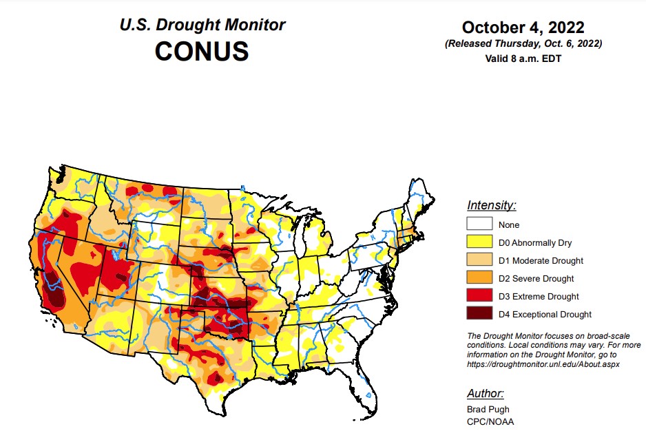
According the this week’s U.S. Drought Monitor Report, major Hurricane Ian made landfall in southwestern Florida on September 28 and then reemerged offshore of the Atlantic coast, with another landfall near Georgetown, South Carolina two days later. Excessive rainfall (more than 10 inches) caused widespread inland flooding throughout the central Florida Peninsula and heavy rainfall overspread the Carolinas, Mid-Atlantic, and central Appalachians. After a mid-level low pressure system tracked inland from the northeastern Pacific and became stationary over the interior West, heavy precipitation (1 to 3 inches) occurred across northern Idaho along with the north-central Rockies. Therefore, improvements were made across much of the East and north-central Rockies. Conversely, a dry week resulted in an expansion of abnormal dryness (D0) and moderate drought (D1) along with intensifying drought conditions across much of the Great Plains, Mississippi Valley, and Midwest. D1 was added to parts of the Pacific Northwest. A mix of improvements and degradations were made to Hawaii, while Alaska and Puerto Rico remain drought-free.
To view the U.S. Drought Map, click here.
In the Southern Plains, due to a very dry pattern during the past month along with periods of above-normal temperatures, a 1-category degradation was necessary for parts of the Ozarks, lower Mississippi Valley, western Gulf Coast, and southern Great Plains. 30-day precipitation deficits exceed 4 inches in eastern Oklahoma and northwestern Arkansas. Much of these areas along with interior portions of southeastern Texas have received less than 0.10 inch of rainfall during the past 30 days. 30-day SPI/SPEI along with NLDAS and NASA SPoRT soil moisture were the primary indicators used in depicting these degradations along with recommendations from regional partners. Low to dry ponds, poor pastures, and cattle selloffs continue to be major impacts for Arkansas and Oklahoma. Although moderate drought (D1) was added to southwestern Louisiana, a broader D1 coverage was not designated this week due to a strong wet signal at 60 days and lack of support from soil moisture indicators. A couple of small D1 areas were added to Tennessee (near Nashville and northeast of Chattanooga), based on SPI/SPEIs and declining soil moisture.
In the High Plains, short and long-term NDMC blends, SPIs, soil moisture, and crop conditions support a 1-category degradation for southern South Dakota, southwestern Nebraska, and parts of Kansas. Pond levels are low in Kansas and limited soil moisture is available for winter wheat planting. Abundant recent precipitation (locally more than 2 inches) prompted improvements along the western slopes of the Colorado Rockies. Improvements were also made to northeastern Colorado due to relatively significant precipitation (more than 0.5 inch) this past week. Following heavy precipitation during early August, little to no rainfall for a six week period resulted in an increase in D1 across southeastern Colorado. Beneficial precipitation during the past 30 to 60 days along with improving soil moisture conditions prompted improvements across parts of Wyoming.
In the West, late summer heat and increasing 90-day precipitation deficits of more than 6 inches resulted in the addition of short-term moderate drought (D1) to parts of northwest Oregon and western Washington. This new D1 area is supported by 30 to 120-day SPI values, near record low 28-day streamflows for this time of year, and declining soil moisture. Conversely, heavy precipitation (1 to 4 inches) supported a broad 1-category improvement across parts of west-central Montana and the impact was changed from SL to L only. 12 to 24-month SPI values continue to support D1+ throughout western Montana. Based in part on above-normal temperatures during August and September, 1-category degradations were made to parts of southern Idaho. Farther to the north, beneficial precipitation during the past week resulted in a 1-cateogry improvement to northern Idaho. Although Arizona and much of New Mexico were status quo this week, this region will be reevaluated next week as many areas received more than 0.5 inch of rainfall from September 27 to October 3 and it was a wet Monsoon for the Southwest.
Looking ahead, from October 6 to 10, mid-level low pressure, the tail end of a front, and enhanced moisture from the East Pacific are expected to bring widespread rainfall (1 to 3 inches) to eastern Arizona, New Mexico, and the northern Texas Panhandle. Elsewhere, across the contiguous United States, little to no precipitation is forecast. Behind a cold front, below-normal temperatures are forecast to shift southeastward across the central and eastern U.S. The first frost or light freeze of the season may affect the Corn Belt. Above-normal temperatures are likely to persist throughout the northwestern U.S.
The Climate Prediction Center’s 6-10 day outlook (valid October 11-15, 2022) expects a variable temperature pattern during this 5-day period. Below-normal temperatures are most likely across the Rockies and Southwest, while above normal temperatures are favored for the Pacific Northwest and lower to middle Mississippi Valley. Probabilities for above-normal precipitation are elevated across the southwestern and south-central U.S. with a likely continuation of a drier-than-normal pattern for the Pacific Northwest.
To view the 6-10 Day Precipitation Outlook Map, click here.
To view the 6-10 Day Temperature Outlook Map, click here.
To view the Monthly Drought Outlook Map, click here.
WebReadyTM Powered by WireReady® NSI
Top Agricultural News
More Headlines...

