

Sat, 26 Nov 2022 17:38:42 CST
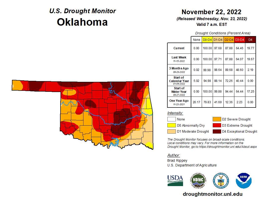
There is little change in the latest Oklahoma Drought Monitor that was released on Thanksgiving morning, November 24th. The drought status on conditions as of Tuesday morning, November 22, 2022.
All of Oklahoma remains abnormally dry or worse in the latest week versus a week earlier.
97.68% of the state is in moderate drought or worse- versus 97.71% a week earlier.
87.88% of Oklahoma is in severe drought or worse- exactly the same as a week earlier.
64.6% of the state is a exteme drought or worse- versus 64.07% a week earlier/
19.77% of Oklahoma is in exceptional drought- versus 19.57% a week ago. There are five areas across the state in exceptional drought- from Texas County in the Panhandle to three areas bordering Kansas from Harper County to Ottawa County. Eight counties in eastern Oklahoma just south of I-40 including all(or virutally) all of Coal, Hughes, Pontotoc and Seminole counties are in the fifth exceptional drought island.
According to the National Drought Summary- Cold, dry weather prevailed nearly nationwide, with a few exceptions. Notably, mid-November snow squalls developed downwind of the Great Lakes, resulting in localized totals of 2 to 6 feet or more. In addition, precipitation fell in parts of the South, East, and Midwest, primarily early in the drought-monitoring period, although most liquid-equivalent totals were under 2 inches. Snow broadly blanketed the Midwest and interior Northeast, especially on November 15-16, although amounts were mostly light to moderately heavy. Meanwhile, deep snow from a previous storm remained on the ground in much of Montana and North Dakota. As the period progressed, rain lingered in the western Gulf Coast region. Elsewhere, negligible precipitation fell across the western half of the country. On the Plains, the combination of cold weather and soil moisture shortages maintained significant stress on rangeland, pastures, and winter wheat. Weekly temperatures averaged at least 10°F below normal nationwide, except in the Desert Southwest and along the Atlantic and Pacific Coasts.
The National Weather Service 6- to 10-day outlook for November 28 through December 2 calls for the likelihood of below-normal temperatures across the northern Plains and much of the West, while warmer-than-normal weather will prevail east of a line from the southern Rockies to Lake Michigan. Meanwhile, near- or below-normal precipitation in much of the southern and eastern U.S. should contrast with wetter-than-normal conditions from the Pacific Coast to the northern half of the Plains, Midwest, and mid-South.
More details on the latest Drought Monitor is available here.


