

According to the Oklahoma Mesonet, there are increased odds of below-normal temperatures next week and possibly on Christmas.
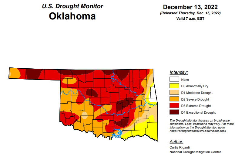
According to the latest drought monitor report, in Oklahoma, exceptional drought is down quite a bit from last week at 11.64 percent. Last week’s percentage was 19.88.
Extreme drought or worse is down from last week’s 64.01 percent, now at 57.35 percent.
Severe drought or worse has dropped slightly from last week’s 85.98 to now 83.45.
Moderate drought or worse has also dropped slightly from last week and is now at 90.18 percent. Last week was at 91.21 percent.
Abnormally dry conditions have dropped from last week’s 99.97 percent to 98.45 percent.
According to the 6–10-day precipitation outlook map for Oklahoma, the entire state, aside from the panhandle is leaning below a 33-40 percent chance of precipitation through December 24. The panhandle is sitting at “near normal” probability for receiving some moisture.
To view the Oklahoma Drought Map, click here.
To view the United States Drought Monitor Report, click here.
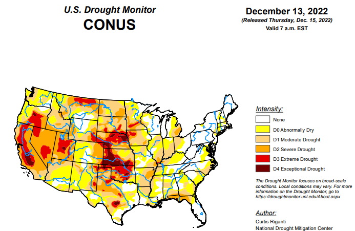
According to the latest U.S. drought monitor report, while much of the contiguous U.S. is still experiencing drought or abnormal dryness, several storm systems dropped large amounts of precipitation over the past week in the form of rain or snow, especially in California and from eastern Oklahoma through Tennessee. Since some of this precipitation fell near the Tuesday morning data cutoff, more analysis of the early week precipitation will be performed next week, when more data is available to analyze changes to ongoing drought conditions. In parts of the Great Lakes, Southeast, and northwest Kansas that missed out on recent precipitation, drought or abnormal dryness developed or worsened.
In the Southern Plains, northern parts of the region, from central and eastern Oklahoma eastward through Tennessee, widespread moderate to heavy rain fell, leading to widespread improvements to ongoing drought and abnormal dryness. In central Oklahoma and north Texas, given that some of this rain fell near the data cutoff, more changes may be made next week as more data becomes available. Wetter recent weather led to improvements in surface conditions and precipitation deficits in central and west-central Texas, leading to some improvements in ongoing drought there. Due to recent heavy rainfall, severe drought areas in southwest Arkansas and near the Louisiana/Mississippi border were removed. A few localized spots in the eastern half of Texas saw conditions worsen after missing out on recent rains. Most of the region saw above-normal temperatures this week, with large portions of central and eastern Texas, Louisiana, and Mississippi seeing readings at least 15 degrees above normal.
In the High Plains, heavier rains accumulated Monday night into early Tuesday in parts of southeast Kansas, leading to some improvements in the drought situation there as precipitation deficits lessened. Dry weather continued in parts of northwest Kansas, where soil moisture deficits and long-term precipitation deficits continued to worsen. A few small changes (one improvement and one degradation) were made in southeast Colorado and adjacent northeast New Mexico, where surface conditions changed in tandem with recent precipitation or lack thereof. Elsewhere, conditions did not change much across the region. Snow and rain that fell Monday night and Tuesday morning from northeast Colorado into Nebraska and southern South Dakota will be analyzed further next week for possible improvements to ongoing drought. Temperature anomalies for the week varied from north to south across the region, with below-normal temperatures occurring in most of North Dakota, while near- or slightly above-normal temperatures were more common in Colorado and Kansas.
In the West, widespread improvements to ongoing drought occurred across parts of the West region this week, due to copious amounts of rain or snow. Hefty rainfall amounts in some of the coastal mountain ranges of California caused high streamflow, which lessened precipitation deficits and led to localized improvements. Widespread improvements occurred in parts of the central Sierra Nevada range, where heavy snow fell and added to a healthy early-season snowpack. Recent rain and snow also improved conditions in parts of Arizona, Nevada, Utah, Idaho, southwest Montana, and near the Columbia River along the Arizona/Washington border. Despite recent precipitation, a small part of southwest Oregon saw abnormal dryness develop where precipitation and soil moisture deficits mounted. Temperatures across the West region were generally near or a bit below normal, with the exceptions of New Mexico and eastern Montana, which had above- and below-normal temperatures, respectively.
Looking ahead, according to forecasts from the National Weather Service (NWS) Weather Prediction Center, as the weekend progresses into early next week, most areas east of the Rocky Mountains may expect near- or slightly below-normal temperatures. Meanwhile, a much-colder-than-normal airmass should build into the northern Great Plains. Widespread precipitation is forecast for the Great Lakes region through Monday evening, and from the southern Appalachians into the Northeast.
From December 20-28, the NWS Climate Prediction Center outlooks suggest that this cold airmass will spill into parts of the central and eastern U.S., where high confidence forecasts of below-normal temperatures exist. In parts of California and Nevada, forecasts lean toward above-normal temperatures during this period, especially from December 22-28. Precipitation forecasts lean toward above-normal precipitation for the Northern Rockies, Pacific Northwest, Northern Great Plains, and Northeast from December 20-28. Drier-than-normal weather is favored in the Desert Southwest, Southern Great Plains, and the Ohio and Tennessee River valleys. For Alaska, above-normal precipitation is favored in the southern part of the state, while below-normal precipitation is favored in the northern part of the state. The temperature forecasts vary more between the 6-10 and 8-14 day periods, but generally, below-normal temperatures are more likely in eastern Alaska, while the Aleutian Islands are more likely to see warmer-than-normal temperatures.
To view the 6-10 Day Precipitation Outlook Map, click here.
To view the 6-10 Day Temperature Outlook Map, click here.
To view the Monthly Drought Outlook Map, click here.


