

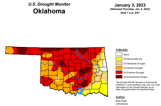
Last week, Oklahoma’s drought conditions remained unchanged from the week prior. According to this week’s drought monitor, those conditions from two weeks ago have carried into this week, leaving Oklahoma at a three week stand-still on those drought percentages.
Exceptional drought- 11.65 percent
Extreme drought or worse – 56.13 percent
Severe drought or worse – 80.92 percent
Moderate drought or worse – 89.73 percent
Abnormally dry or worse- 98.18 percent
To view the Oklahoma Drought Map, click here.
According to the 6-10 day precipitation outlook map, the majority of the state minus the southern border is leaning below a 33-40 percent chance of precipitation through January 15, 2023. The southern border of Oklahoma has a “near normal” chance of precipitation.
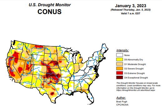
To view the United States Drought Monitor Report, click here.
According to the latest U.S. Drought Monitor Report, An atmospheric river (AR) led to heavy rain and high-elevation snow across the West with the largest amounts throughout California on December 30 and 31. Preceding this AR, enhanced onshore flow also resulted in widespread rain and high-elevation snow from the West Coast eastward to the Continental Divide. 7-day total amounts (liquid equivalent), from December 27, 2022 – January 2, 2023, ranged from 2 to 6 inches (locally more) across much of California, western Oregon and Washington, and parts of the Great Basin and central Rockies. A pair of low pressure systems brought widespread, heavy rainfall (1 to 3 inches, locally more) from the lower Mississippi Valley northward to the Ohio Valley. A winter storm affected southern South Dakota and western to central Nebraska where 6 to 18 inches of snowfall occurred on January 2. Mostly dry weather prevailed along most of the East Coast and southern Great Plains. Following the Arctic air outbreak during late December, a rapid warming trend began during the final days of 2022. 5-day temperatures (December 27, 2022 – January 2, 2023) averaged more than 10 degrees F above normal across the central and eastern U.S.
In the Southern Plains, Widespread heavy rainfall (2 to 6 inches) resulted in a broad 1-category improvement to the lower Mississippi Valley and eastern Texas, which makes much of these areas drought-free. Degradations made to central and southern Texas were based on SPI at various time scales and 28-day streamflow. Following a dry week, much of Oklahoma and northwestern Texas remain designated with severe (D2) to exceptional (D4) drought.
In the High Plains, based on heavy precipitation (1 to 3 inches, liquid equivalent) this past week along with above-normal snowpack, a 1-category improvement was made to western Colorado. Beneficial precipitation also prompted improving drought conditions across north-central and northeastern Colorado. A decrease in the spatial coverage of extreme (D3) drought was made to central Nebraska. 12-month SPI and the long-term blend support the continued widespread severe (D2) to exceptional (D4) drought coverage for the central Plains. Norfolk, Nebraska, with a period of record dating back to 1888, had its driest year on record in 2022.
In the West, A long-term drought, dating back to the 2019-2020 winter, continues across California, the Great Basin, and parts of the Pacific Northwest. One-category improvements to severe (D2), extreme (D3), and exceptional (D4) drought made this week in California, Nevada, and Utah balanced recent heavy precipitation with 24 to 36-month SPIs. As of January 4, snow water equivalent (SWE) is running 133, 182, and 205 percent of normal for the Northern, Central, and Southern Sierra Nevada Mountains, respectively. Water-year-to-date (WYTD) precipitation, valid since October 1, 2022, has averaged more than 150 percent of normal across central California. Despite this favorable start to the wet season across California, a number of major water supply reservoirs remain below 60 percent of their historical average. The Trinity reservoir in northern California was only 38 percent of average, as of January 3. The lowest 36-month SPIs (< -2) are focused across northern California and south-central Oregon. In addition, WYTD precipitation remains below-normal across northwestern California despite the heavy precipitation at the end of December 2022. Elsewhere, across northwestern Oregon and western Washington, improvements were necessary after above-normal precipitation this past week and the short-term drought impact was discontinued given the recent wetness. Near and to the east of Seattle, 28-day streamflows remain below the 20th percentile, supporting moderate (D1) drought. Abnormal dryness (D0) was maintained for the Olympic Peninsula where SWE is running below-normal. A mix of small improvements and degradations were made to Montana based on SPI/SPEI at various time scales and current snowpack.
To view the 6-10 Day Precipitation Outlook Map, click here.
To view the 6-10 Day Temperature Outlook Map, click here.
To view the Monthly Drought Outlook Map, click here.


