

After weeks of unchanged drought percentages in the weekly drought monitor, this week in Oklahoma shows only slight changes in the numbers. According to the Oklahoma Mesonet, temperatures should be cooling down for the next few days.
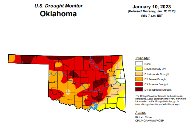
Exceptional drought is up slightly from last week’s 11.65 percent and is now at 11.77 percent.
Extreme drought or worse has increased from last week’s 56.13 percent and is now at 57.21 percent.
Severe drought or worse has increased from last week’s 80.92 percent to this week’s 81.01 percent.
Moderately dry or worse has decreased from last week’s 89.73 percent to this week’s 89.12 percent.
Abnormally dry or worse conditions have decreased from last week’s 98.18 percent to this week’s 97.46 percent.
To view the Oklahoma Drought Map, click here.
According to the 6-10-day precipitation outlook map, through January 21, the majority of the state is leaning above a 40-50 percent chance of precipitation. The northeast corner of the state and along the far east border is likely above a 50 to 60 percent chance of precipitation. The farthest southwest corner is leaning above a 33 to 40 percent chance.
To view the United States Drought Monitor Report, click here.
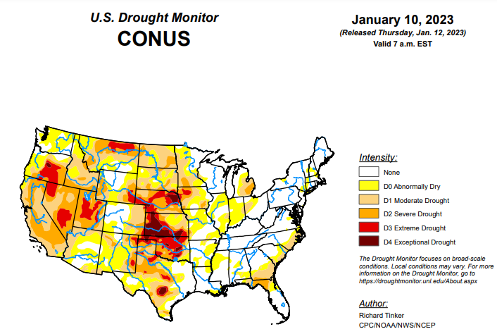
According to the latest U.S. drought monitor report, a series of atmospheric rivers (AR) led to heavy rain and high-elevation snow across parts of the West, especially across California. Precipitation totals exceeding 4 inches (liquid-equivalent) were widespread, and several areas in and near the Sierra Nevada, Cascades, and coastal ranges recorded over one foot of precipitation. Moderate to heavy precipitation was also common along the coast and in the higher elevations of the Pacific Northwest, some higher elevations in the central and northern Rockies, part of the upper Midwest, portions of the lower Mississippi Valley, the interior Southeast, and scattered locales across the Ohio Valley and the Northeast. Precipitation totals generally exceeded 1.5 inches, and topped 4 inches in parts of the Southeast, central Utah, and the higher elevations in the Pacific Northwest. Much of the precipitation fell on areas experiencing dryness and drought, so across the country, improvement was much more common than deterioration. Mild temperatures prevailed across the country except where significant precipitation was observed in the northern Plains and Far West. Daily high temperatures averaged more than 12 deg. F above normal in central and southern Texas while daily low temperatures averaged 10 to 13 deg. F above normal across the Great Lakes, the Southeast, and the southern Plains.
In the Southern Plains, moderate to locally heavy rain in Tennessee and Mississippi kept those states free from drought. The small area of D0 remaining in Tennessee was removed, and D0 areas in Mississippi contracted slightly. Moderate to locally heavy rain also fell on most of Louisiana and eastern Texas, reducing the extent of D0 in northern Louisiana and improving the west side of the D0 and D1 areas in the Bayou. Farther west, little or no precipitation fell. Exacerbated by much above normal temperatures, conditions deteriorated in portions of Texas and Oklahoma, although most locations were unchanged by the week’s dryness. Much of Oklahoma remained in extreme drought (D3), and similarly dry conditions existed across scattered areas in central and northern Texas. Exceptional drought (D4) now covers part of central Texas, scattered areas across Oklahoma, along with the northern tier of the state. 90-day precipitation amounts were only 10 to 25 percent of normal through the Oklahoma Panhandle, part of adjacent Texas, and in far western Texas from Big Bend National Park northwestward for a few hundred miles along the Rio Grande. Locations in and near the central Texas D4 region recorded 3 to 5 inches less precipitation than normal during this period.
In the High Plains, most of the Region was much drier than the prior week, with a few tenths of an inch of precipitation restricted to southeastern South Dakota and adjacent portions of Nebraska, as well as isolated sites in the higher elevations of Colorado and southern Wyoming. Other areas recorded little if any precipitation. Most of the region remained unchanged from last week, but some improvement occurred in southeastern South Dakota and adjacent Nebraska. No areas appeared to deteriorate significantly due to the heavy precipitation of the previous week and seasonably cold temperatures reducing human and natural water demand. But most of the region remained in at least moderate drought (D1), with extreme to exceptional drought (D3-D4) stretching from southeastern Wyoming eastward across most of Nebraska into adjacent Iowa, and southward from western Nebraska through most of southern and western Kansas. A broad swath covering the southwestern half of Kansas and much of northeastern Nebraska remained in exceptional drought (D4).
In the West, a long-term drought, dating back to the 2019-2020 winter, continues across California, the Great Basin, and parts of the Pacific Northwest. However, the intense precipitation in California the past few weeks – particularly late December and early January – has significantly reduced drought intensity in California. Most of the state saw a 1-category improvement this week. The D3 across interior northern and central California that covered over 35 percent of the state two weeks ago, is now confined to a small area adjacent to Oregon. But Despite the record and near-record precipitation over the past 6 weeks, large parts of the state remain in D1-D2 since moisture deficits have been entrenched across some areas for the last 2-3 years. At least one-third of the state has been in drought (D1+) since February 2020.
To view the 6-10 Day Precipitation Outlook Map, click here.
To view the 6-10 Day Temperature Outlook Map, click here.
To view the Monthly Drought Outlook Map, click here.


