

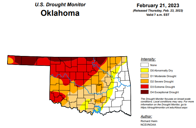
After drought conditions showed improvement in each category last week, this week’s Oklahoma drought monitor shows slight increases in the exceptional drought and extreme drought categories. As for the other three categories of drought, those continue to show improvement.
To view the Oklahoma Drought Map, click here.
Exceptional drought increased slightly from last week’s 8.07 percent to 8.86 percent this week.
Extreme drought or worse has also increased just slightly from last week’s 36.58 percent to this week’s 36.64 percent.
Severe drought or worse is now at 56.47, down over 10 percentage points from last week’s percentage of 66.94.
Moderate drought or worse is now at 74.65 percent, down from last week’s 80.07 percent.
Abnormally dry or worse conditions are now at 80.78 percent, down from last week’s 85.03 percent.
According to the 6-to-10-day precipitation outlook map, the majority of the state with the exception of the southern border is leaning above a 33 to 40 percent chance of precipitation through March 4. As for that southern border, that part of the state is standing at a near-normal percent chance of precipitation through March 4.
To view the United States Drought Monitor Report, click here.
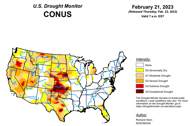
According to the latest U.S. drought monitor report, an upper-level ridge over the northeastern North Pacific Ocean deflected Pacific storm systems away from the West Coast of the contiguous U.S. (CONUS) during this U.S. Drought Monitor (USDM) week (February 15-21). This resulted in a generally drier-than-normal week over much of the West. An upper-level trough developed over the western CONUS downstream from the ridge, and the trough was responsible for a cooler-than-normal week over the West. Strong high pressure over the Gulf of Mexico extended into a ridge across the East Coast. A southerly flow between the trough and eastern ridge spread warm, moist air from the Gulf of Mexico across the eastern CONUS and directed weather systems northeastward from the southern Plains to Great Lakes. Two weather systems early in the week generated above-normal precipitation across parts of the central to eastern CONUS. As the week ended, weather systems moved across the northern tier states, bringing areas of snow. The week was wetter than normal across parts of the northern Rockies, from the Four Corners states to western Great Lakes, and from the central Gulf Coast states to Ohio Valley and Mid-Atlantic states. It was a drier-than-normal week across much of the West, southern Plains, coastal Southeast, and southern Great Lakes to New England, and parts of the northern to central Plains. Drought or abnormal dryness expanded where it continued dry in parts of the Pacific Northwest, southern Plains, and Florida. Drought or abnormal dryness contracted or reduced in intensity where it was wet over parts of the Four Corners area, southern and central Plains to Upper Mississippi Valley, and the Big Island in Hawaii.
In the Southern Plains, two inches or more of precipitation fell across eastern portions of the South region, specifically parts of Mississippi and much of Tennessee. Half an inch or more occurred from there to eastern Oklahoma and northeast Texas. For the rest of Oklahoma and Texas, the week continued a dry pattern. Abnormal dryness and moderate to extreme drought contracted in eastern Oklahoma, due to wet conditions this week and previous weeks and improved soil moisture and streamflow conditions, and abnormal dryness contracted in northeast Texas. But extreme to exceptional drought expanded in western Oklahoma and the Texas panhandle, while abnormal dryness and moderate to severe drought expanded in parts of southern Texas along the coast and along the Rio Grande River where streamflow and soil moisture conditions deteriorated and precipitation deficits continued to grow. According to media reports, 80-mph winds created a dust storm in the Oklahoma panhandle that caused a multiple car pileup, killing a driver.
In the High Plains, a storm system tracked across southern parts of the High Plains region early in the week, with another late in the week tracking across northern Wyoming. Weekly precipitation totals were half an inch to over an inch in parts of Wyoming, Colorado, northern and eastern Kansas, southern and eastern Nebraska, and southeast South Dakota. The rest of the region received little to no precipitation. Moderate to exceptional drought was trimmed in a few areas of northwestern and eastern Kansas, and adjacent parts of Nebraska, while abnormal dryness and severe drought were trimmed in southern Colorado. No change was made to the drought areas in the rest of the region.
In the West, half an inch of precipitation fell over a few areas in the Four Corners states and in western Oregon, while 2 inches or more of precipitation occurred over parts of the Washington Cascades and northern Rockies. But for the most part, little to no precipitation fell across large parts of the West region. Abnormal dryness and moderate to severe drought were trimmed in northwest New Mexico where this week was wet and moist conditions were evident in soil moisture, snowpack, and Standardized Precipitation Index (SPI) indicators. But low streamflow, snowpack, soil moisture, and SPI values prompted expansion of abnormal dryness and moderate drought along coastal Oregon and southwest Washington, as well as in the Idaho panhandle. While many reservoirs in California have recovered from the recent atmospheric river events that have struck that state, reservoirs in Oregon continue at drastically low levels and some reservoirs in Utah remain at low levels. As of February 21, 2023, the water level in Lake Powell was 3521.53 feet above sea level, which is the lowest level recorded since the lake was filled in the 1960s. As noted by the media, Lake Powell is a man-made reservoir that sits along the Colorado River on the Arizona-Utah border. It generates electricity for about 4.5 million people and is a key part of the Colorado River Basin system, which supplies water to more than 40 million people. Further north, an extension agent in Blaine County, Montana, reported the drought is causing reduced water for irrigation, later emergence of spring grasses, and grazing must be supplemented and water hauled for livestock.
Looking ahead, a strong Pacific weather system moved across the West on February 22, with a low pressure and frontal system spreading rain and snow from the Plains to Mississippi Valley and across northern states. A series of weather systems will follow during February 23-28, spreading an inch or more of precipitation from Oklahoma to the Great Lakes, from the Tennessee to Ohio Valleys, and across much of the Northeast, as well as along the West Coast and into the interior West. Some precipitation totals will exceed 2 inches in the Upper Mississippi Valley and western Great Lakes, and exceed 4 inches along coastal Washington and California and into the Sierra Nevada range. The Gulf of Mexico Coast, western parts of the Great Plains, and parts of the Mid-Atlantic Coast will see little to no precipitation. High pressure over the Gulf of Mexico will keep temperatures warmer than normal from the southern Plains to Ohio Valley and Gulf Coast to Mid-Atlantic Coast, while temperatures will be cooler than normal across the Far West to northern Plains. For February 28-March 8, the outlook favors colder-than-normal weather across the West and Alaska, with warmer-than-normal weather from the southern Plains to Atlantic Coast and Great Lakes. Above-normal precipitation is likely across Alaska, the western CONUS, and much of the CONUS east of the Rockies except along the Gulf Coast where below-normal precipitation is favored.
To view the 6-10 Day Precipitation Outlook Map, click here.
To view the 6-10 Day Temperature Outlook Map, click here.
To view the Monthly Drought Outlook Map, click here.


