

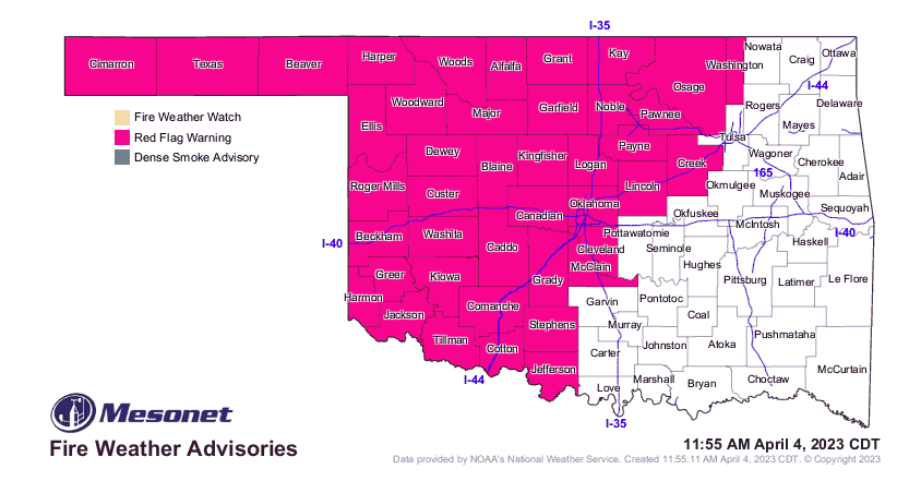
Statewide Discussion: A widespread Red Flag Warning is in effect today across Oklahoma, generally along and northwest of I-44. Today presents a complicated forecast with fire weather over very receptive fuels while an enhanced risk for severe weather enters the mix overnight in eastern and southeastern Oklahoma. Focusing on the fire danger today, temperatures +15°-20° above normal coupled with very dry air and strong/gusty southwest winds over dry fuels subjected to intensive drying in recent days will result in extreme fire danger over a broad area centered around northwest Oklahoma. Conditions do moderate following frontal passage overnight although elevated fire weather will remain in place over western Oklahoma through the remainder of the week.
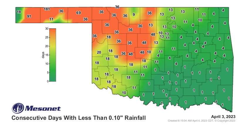
Today: Intensive drying yesterday with afternoon relative humidity observations in western Oklahoma as low as 4% and very poor overnight moisture recovery in northwestern and far-western Oklahoma sets the stage for super-receptive fuels today during a critical to an extreme fire-effective weather event. Dewpoint temperature in the single digits this morning will support single-digit relative humidity observations again today as temperature move above normal and a dryline drives into Oklahoma. This weather system is similar to what Oklahoma experienced on Friday with a few differences: 1) The system is displaced a bit further west centered in northwestern Oklahoma, 2) Ambient fuel load is below normal given persistent drought limiting fire behavior to some extent, 3) Fuels, however, have been subjected to intensive drying suggesting increased resistance to control, 4) High cirrus clouds and blowing dust may offer enough sky cover to limit fine-dead fuel moisture from reaching minimum dryness, and 5) Cold front passage is expected to be around midnight or after as opposed to during peak burning conditions. Those cirrus clouds may inhibit satellite monitoring
and detection.
• 40% Area (Map Above/Right): With no overnight moisture recovery in the Panhandle, northwest and far western
Oklahoma, potential for troublesome fire behavior on early starts is high. A dryline will migrate into the state supporting
extreme fire weather development over very receptive fuels. The temperature will soar into the mid-70°’s to possibly upper80°’s with relative humidity values 7-11% yielding fine-dead fuel moisture values at 2%. Some cirrus clouds and blowing dust may hold observations at 3% but still very receptive. Southwest winds sustained 28-35 mph with gusts nearing 60 mph will support rapid rates of spread. In rangeland fuels, head fire rates of spread 182-295 ft/min (2.1-3.3 mph) are likely during peak burning conditions with 10-16 ft flame lengths. Pockets of heavier fuels will exhibit short duration runs approaching 350 ft/min (3.9 mph) and problematic fire behavior including torching, spotting (up to ¼ mile) and rapid runs is expected. Frontal passage will result in a shift to northwesterly winds after midnight with winds gradually diminishing overnight.
• Along/North of I-44: Respectable overnight moisture recovery will somewhat delay the development of active burning
conditions, although the number of fires occurring Friday through Monday have placed additional ignition sources in the
environment. As the dryline angles into central Oklahoma and north-central Oklahoma, a critical burning period lasting
approximately 4-5 hours will develop around 1:00 continuing into the evening. Temperature in the mid- to upper 80°’s with relative humidity values generally 14-23% under lingering cirrus clouds will register 3-5% or receptive to very-receptive. Winds will increase becoming southwesterly sustained 14-25 mph gusting to near 40 mph at times. Grass dominated fuels will exhibit head fire rates of spread 128-187 ft/min (+/-2.0 mph) flame lengths 9-14 ft. Mixed fuels will exhibit problematic fire behavior including torching, short crown runs and frequent spotting. Frontal wind shifts expected after 2:00 AM
Near-Term: After today’s extreme fire danger event, conditions do moderate a bit in the post-frontal environment although dry conditions persist in western Oklahoma. Opportunity to gain control on fires that develop today will be good on Wednesday and Thursday. Currently, there is at least a glimmer of hope for a bit of rain in the west on Sunday although amounts are negligible. Overall a dry pattern is expected in the drought stricken area of Oklahoma. Fortunately, no significant fire weather is on deck in the next week given current forecast information.


