

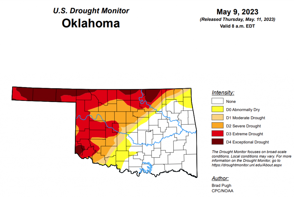
To view the Oklahoma Drought Map, click here.
According to the latest Oklahoma Drought Map, Exceptional drought is unchanged from last week, remaining at 10.09 percent.
Extreme drought or worse has decreased only minimally, changing from last week’s 33.47 percent to this week’s 33.10 percent.
Severe drought or worse also saw minimal changes, improving slightly from last week’s 48.9 percent to this week’s 48.07 percent.
Moderate drought or worse is unchanged from last week, remaining at 52.47 percent.
Abnormally dry or worse conditions have actually worsened since last week, moving from 59.42 percent to this week’s 60.81 percent.
According to the 6-10-day precipitation outlook map, the northeastern corner of the state is standing at a “near normal” chance of precipitation through May 10. East of the panhandle down through central Oklahoma and into the southeast corner of the state is leaning above a 33 to 40 percent chance of precipitation. The panhandle, down through the southwest corner stands at a 40 to 50 percent chance of precipitation. Lastly, the far western corner of the panhandle is likely above a 50 to 60 percent chance of precipitation through May 10.
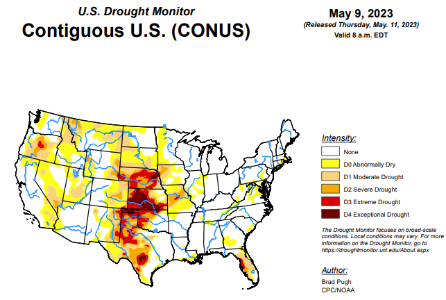
To view the United States Drought Map, click here.
According to the latest U.S. Drought Monitor, a strong area of mid-level low pressure, near the West Coast, resulted in anomalously wet weather during the first week of May throughout the Pacific Northwest, Northern Rockies, Great Basin, and California. Scattered thunderstorms brought pockets of heavy rainfall (more than 2 inches), from May 2 to 8, to parts of Texas, central Nebraska, and the Midwest. However, much of Kansas, Missouri, and southern Nebraska missed out on this beneficial rainfall. Following a wet end to April across the East, drier weather prevailed this past week from the Mid-Atlantic south to Florida. 7-day temperatures, ending on May 8, averaged below-normal across most of the East along with California, the Great Basin, and Desert Southwest. Weekly temperatures averaged above-normal across the Great Plains.
In the Southern Plains, a mix of degradations and improvements were made this past week to the Southern Great Plains, western Gulf Coast, Lower Mississippi Valley, and Tennessee Valley. Severe drought (D2) was slightly expanded in southeast New Mexico, based on 90-day SPI and USGS 28-day average streamflows falling below the 10th percentile along parts of the Black River. Based on declining soil moisture indicators, extreme drought (D3) was expanded westward across the Edwards Plateau. More than 1.5 inches of rainfall this past week resulted in a 1-category improvement to parts of central and northwest Texas, the Texas Panhandle, and central Oklahoma. According to NDMC’s long-term objective drought blend, there remains a sharp gradient between extreme to exceptional drought (D3-D4) in northwest Oklahoma to anomalously wet conditions in southeast Oklahoma. An increase in abnormal dryness (D0) was warranted for parts of northwest Arkansas based on increasing 30-day precipitation deficits and 28-day average streamflows below the 30th percentile. The D0 coverage was modified across Tennessee after central parts of the state received more than 1.5 inches of rainfall. However, D0 was expanded to include more of western and northeastern Tennessee, based on 30 to 60-day SPI and 28-day average streamflows. Recent heavy rainfall and 120-day SPI supported elimination of D0 in coastal Mississippi and a slight D0 decrease in southeastern LA. Also, the coverage of moderate drought (D1) decreased across southeastern Louisiana. A small area of D0 was added to central Louisiana where 30 to 60-day precipitation deficits are increasing.
In the High Plains, convective rainfall, typical for early May, occurred this past week across parts of Kansas and Nebraska. In areas such as central Nebraska, that received more than 2 inches of rainfall and there was a lack of support from SPI at various time scales and NDMC’s objective drought blends, a 1-category improvement was made. However, in areas that missed out on this rainfall, a 1-category degradation was necessary for parts of southern Nebraska and central to eastern Kansas. According to the U.S. Department of Agriculture, 64 and 68 percent of the pastures and ranges for Kansas and Nebraska, respectively, are rated poor to very poor. Abnormal dryness (D0) was expanded westward near and along the Colorado Rockies based on SPIs at various time scales, while an increase in severe drought (D2) coverage was justified for parts of the High Plains of eastern Colorado that missed out on the recent heavier precipitation. Based on multiple indicators including Condition Monitoring Observer Reports, abnormal dryness (D0) was reduced across northern parts of North Dakota.
In the West, 30 to 60-day SPI along with soil moisture indicators support an expansion of abnormal dryness (D0) and moderate drought (D1) across southeastern Montana. 30 to 90-day SPIs, recent warmth, and soil moisture led to a 1-category degradation in northwestern Montana. Following major improvements during the past few months across California and the Great Basin, no changes were made this week after little or no precipitation. Drought of varying intensity is designated for parts of Oregon and northern Idaho where precipitation averaged below-normal for the Water Year to Date (October 1, 2022 to May 1, 2023).
Looking ahead, during the next five days (May 11 – 15, 2023), widespread moderate to heavy rainfall (1 to 5 inches, locally more) is forecast across the Great Plains with the heaviest amounts expected to occur from southwestern Oklahoma south to the Middle Rio Grande Valley. Lighter amounts are predicted for southeastern Nebraska, northeastern Kansas, and the Middle Mississippi Valley. Rainfall amounts are expected to vary throughout the Midwest and Southeast, while the Northeast remains mostly dry. Compared to the start of May, much drier weather is forecast for the West.
The Climate Prediction Center’s 6-10 day outlook (valid May 16-20) depicts a highly amplified pattern with anomalous mid-level high pressure over the Northwest. Therefore, large probabilities for above-normal temperatures are forecast throughout the West. Associated with a wetter pattern likely for the south-central U.S. during mid-May, below-normal temperatures are favored for the Southern Great Plains and Lower Mississippi Valley. Below-normal temperatures are also favored across the Great Lakes, Eastern Corn Belt, and Northeast, while above-normal temperatures are more likely across the Southeast. Above-normal precipitation is favored across the southern tier of the U.S. with the largest probabilities forecast for the Southwest which is typically dry during this time of year. Elevated probabilities for below-normal precipitation are forecast across the Northern to Central Great Plains, Upper to Middle Mississippi Valley, and Corn Belt.
To view the 6-10 Day Precipitation Outlook Map, click here.
To view the 6-10 Day Temperature Outlook Map, click here.
To view the Monthly Drought Outlook Map, click here.


