


Farm Director KC Sheperd caught up with Oklahoma State Climatologist Gary McManus to talk about the weather, and McManus provided the news that all Oklahomans have been waiting for.
“I’d be a fool in Oklahoma to confirm any good news on the weather,” McManus said with a laugh. “It does look like we will be on the downward slide with temperatures.”
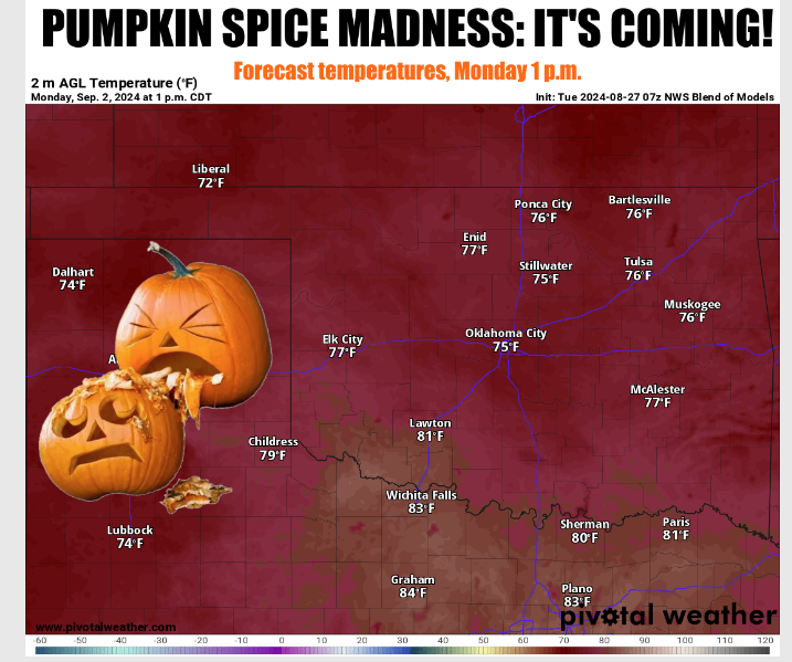
A slight cold front is expected to move into the state on Thursday or Friday, but the big news is the major cold front set to appear early next week dropping temperatures to the upper 70s and lower 80s, with lows possibly in the upper 50s.
“A lot of that depends on what sort of rainfall we might have with it,” he said. “That could keep temperatures down in some parts of the state. In general, it’s going to be cooler as we go forward.”
As the daylight continues to wane, fall weather is inevitable and this year, it appears to be arriving earlier than the norm.
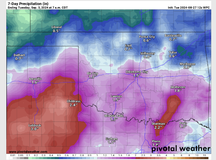
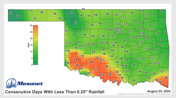
Drought is a major problem in Southwest Oklahoma, and along the Red River throughout most of Southern Oklahoma as well. Parts of Southwest Oklahoma haven’t seen a quarter inch of rain in 85 days from the posting of this article. Mangum has only had 0.84 inches of rain since June 3, 2024. The lack of rain combined with the intense heat in that area throughout the summer makes a bad situation for the region. Some areas have seen even less rain.
Parts of North Central and Northeast Oklahoma are also suffering despite the heavy rainfall they experienced a few weeks ago. “For most of the state, now, its been 10 – 14 days since it’s gotten a quarter inch of rainfall,” McManus said. “That’s what we’ve been seeing off and on throughout the year. We get a good rain, then it takes two or three weeks to get another rainfall.”
Areas in East Central Oklahoma and parts of Northwest Oklahoma into Central Oklahoma still have good soil moisture due to very heavy rainfall a few weeks ago that caused flooding in some areas. However, outside of those few areas, soil moisture is declining quickly.
Like farmers across the state, McManus is hoping the upcoming cold fronts will bring ample rainfall with them. “It’s not much rainfall in the forecast, but it’s certainly better than no rain in the forecast which is what we have been seeing,” he said.
The long-range forecast shows conditions to continue to be hotter and drier than normal, and La Niña is still expected to develop despite her seeming reluctance. “Of course, the strength of that La Niña matters. The cooling of the waters off of the west coast of South America tends to disrupt the air patterns across the globe, and for the Southern tier of the U.S., it brings warmer and drier than normal conditions for the cool season,” McManus said. “We are talking mid-fall to early spring; it tends to bring us those drier conditions.”
Although people don’t generally expect a lot of moisture in the cool season, most of the state will likely be entering the cool season under pretty severe drought conditions. People do count on precipitation in the cool season to recharge soil moisture because there is less heat and sunlight to evaporate the soil moisture as quickly, and a lot of the vegetation is dormant or dead, so it isn’t drawing as much moisture out of the soil either.
“The cool season is an important recharge point for Oklahoma agriculture,” McManus said. “If we don’t get it, if we are in a La Niña, more often than not, we are drier than normal and that is one thing that we definitely don’t want to see because it sets the stage for a bad spring.”


