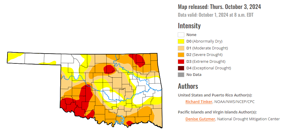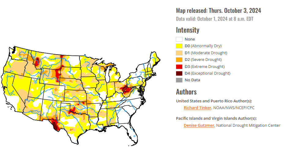
To view the latest Oklahoma drought map, CLICK HERE.
According to the latest Oklahoma drought monitor report, exceptional drought remains at zero percent, unchanged from the start of the calendar year.
Extreme drought or worse conditions have increased to 11.5 percent, up from 6.82 percent last week.
Severe drought or worse has increased to 37.39 percent, up from 33.22 percent last week.
Moderate drought, or worse conditions increased to 61.31 percent, up from 56.51 percent last week.
Abnormally dry or worse conditions increased to 77.18 percent, up from 74.25 percent last week.
According to the 6-to-10-day precipitation outlook map, the majority of Oklahoma is likely below a 50-60 percent chance of precipitation through October 12, 2024. The panhandle is below a 40 – 50 percent chance of precipitation and the far western tip is leaning below a 33 – 40 percent chance of precipitation through that October 12 date.

To view the United States Drought Map, CLICK HERE.
According to the latest U.S. Drought Monitor, Hurricane Helene dropped heavy to excessive amounts of rain on a large area from the Ohio Valley, central Appalachians, and mid-Atlantic Piedmont southward to the eastern Gulf Coast region. The storm moved inland across the Florida Panhandle and northward into the South Atlantic States, then slowed down and drifted westward as it interacted with an upper-level low pressure system, becoming quasi-stationary as it slowly dissipated. The heaviest rains fell where precipitation was orographically enhanced on the east side of the Appalachians. Part of the central North Carolina mountains received 20 to almost 30 inches of rain, with totals topping 10 inches over the rest of the North Carolina mountains as well as the central Blue Ridge in Virginia, part of central and western South Carolina, some patches in central Georgia, and near the landfall site. More than 4 inches soaked a broad area from the middle and lower Ohio Valley southward through eastern Alabama and eastward through the central and southern Appalachians and Piedmont, including most of the Carolinas and Georgia. Widespread flooding resulted, with devastating floods impacting the wetter areas, along with prolonged power outages. Helene is the deadliest tropical system to affect the Nation since Hurricane Katrina in 2005, with a death total was approaching 200 as of this writing. At the same time, the intense rains dramatically improved or ended the various degrees of dryness and drought that had been affecting many of the areas impacted by Helene, especially from the Appalachians westward through the Ohio and Tennessee Valleys and southward to the central Gulf Coast, in addition to much of South Carolina and northern Georgia. Outside the broad area impacted by Helene, subnormal precipitation prevailed across most of the contiguous states. Precipitation was almost non-existent over a large area from the western Great Lakes and most of the Mississippi Valley westward to the Pacific Coast, with only scattered sites in the northern Intermountain West and areas from the northern Cascades to the Pacific Coast receiving over one-tenth of an inch. Above-normal temperatures accompanied the low precipitation totals, resulting in dryness and drought persisting or intensifying across this area covering a majority of the contiguous states. Farther east, the Northeast, mid-Atlantic region, and eastern Great Lakes recorded generally 0.5 to 2.0 inches of rain, with a little more reported in parts of western Michigan, southern and western Pennsylvania, and the higher elevations from upstate New York eastward across Vermont, New Hampshire, and western Maine.
In the Southern Plains, intense rains spawned by Helene dropped 2 to locally 6 inches of rain on Tennessee and northeastern Arkansas, but lesser amounts fell elsewhere. A few tenths of an inch of rain (with isolated higher amounts) fell on parts of eastern Texas and Oklahoma and scattered portions of Louisiana, Mississippi, and the remainder of Arkansas. Other locations recorded little or no rain. Predictably, the heavy rains across Tennessee led to broad-scale reductions in the areal coverage dryness and drought, leaving only south-central parts of the state in drought (D1 and isolated spots of D2). Improvements were also indicated in northern Mississippi and eastern Arkansas, where a re-assessment of conditions demonstrated that early September rainfall from Hurricane Francine was more beneficial than initially thought. Meanwhile, D0 was expanded across southern Louisiana, and areas of deterioration were identified in Texas and Oklahoma, including an expansion of exceptional drought (D4) in the Texas Big Bend, and increased coverage of severe to extreme drought (D2 to D3) in portions of Oklahoma. Rainfall during the past 60 days was less than half of normal in portions of northeastern Oklahoma, the Red River Valley, eastern Texas, and the Texas Big Bend. According to the U.S. Department of Agriculture (USDA), half of the Texas cotton crop was in poor or very poor condition, along with 31 percent of Texas corn and 24 percent of Oklahoma cotton.
In The High Plains, it was very warm and almost bone dry throughout the region, with only a few highly isolated spots of measurable rainfall. Unusually high temperatures worsened the situation, with weekly mean anomalies ranging from +1 to +2 deg. F in eastern Kansas to +15 to +18 deg. F in most of the Dakotas. Wyoming and most of Colorado saw temperatures average near or over 10 deg. F above normal. As a result, dryness and drought in the region was unchanged or worsened. Moderate to severe drought expanded in coverage across the central Great Plains and northern High Plains, with increased areas of extreme drought D3) noted in eastern Wyoming, plus a few spots in the western Dakotas. Over the past 30 days, only a few tenths of an inch of rain at most has fallen on much of Wyoming and Nebraska, northern Kansas, and the southeastern Dakotas.
In the West, some of the higher elevations in Washington recorded 1.0 to locally 2.5 inches of rain while a few tenths of an inch were measured in other parts of the Northwest from the Cascades to the Pacific Coast, and in portions of northern Idaho and northwestern Montana. However, most of the West was very warm and free from any measurable precipitation. A few areas in Utah saw conditions noticeably deteriorate this past week, but no other degradations took place. Some D0 and D1 areas were actually scaled back in central and northwestern Montana despite the warm and dry week due to a few rounds of heavy precipitation in late August and September, which has continued to have a positive impact on soil moisture, vegetative health, and 1- to 4-month precipitation anomalies. Elsewhere, conditions are unchanged from last week. Low relative humidity, high temperatures, and gusty winds continue to produce periods of extreme fire danger, and supplemental feeding and watering of livestock has been common in eastern Montana. With the Southwest monsoon season ending and the wet season in the West not yet underway, drought tends to progress slowly in the region this time of year.
Looking ahead, during the next five days (October 3 – 7), warm and dry weather will dominate the contiguous United States. Very little if any precipitation is expected across a vast majority of the Nation. The Florida Peninsula the immediate rim of the Gulf Coast are significant exceptions, where abundant tropical moisture is expected to feed heavy rainfall. There is some potential for tropical cyclone development over the Gulf later in the period. Over an inch is forecast across the Florida Peninsula and along parts of the immediate Gulf Coast from the Florida Panhandle through coastal southern Texas. Generally 1.5 to 3.0 inches are expected in a swath across the central Florida Peninsula and near the central Gulf Coast, with heavy amounts of 3 to 5 inches forecast on the Florida West Coast from the Tampa area southward through Ft. Myers, and across the Louisiana Bayou. Moderate amounts (0.5 to 1.5 inches) are forecast from the Cascades of Washington and northern Oregon westward to the Pacific Coast, and over parts of northern Idaho and adjacent Montana. Meanwhile, several tenths of an inch are expected across most of the Great Lakes region and the Northeast. Several tenths of an inch are also expected over most of Hawaii, with the largest totals forecast in central Lanai, eastern Maui, and part of the western Big Island. Between 2 and 3 inches are expected to fall on southeasternmost Alaska, where normals are relatively high. Near normal temperatures are expected in most areas east of the Mississippi River while well above-normal temperatures should prevail farther west. Daily maximum temperatures 10 – 15 deg. F above normal are anticipated from the central and northern Plains through most of the Rockies and Intermountain West to near the California Coast. Temperatures are expected to average closer to normal across Hawaii and southeastern Alaska.
The Climate Prediction Center’s 6-10 day outlook (valid October 8 – 12) continues to favor warmer and drier than normal weather for most of the Nation. Above-normal rainfall is expected to continue across the Florida Peninsula, possibly spreading into southern Georgia. Meanwhile, marginally-enhanced chances for wetter than normal weather cover much of Maine, portions of the Far West from the Cascades westward, and west-central California. A much larger area with increased chances for drier-than normal weather stretch across the northern Rockies and from the High Plains eastward through the southern and middle Atlantic Coast. The best odds for subnormal rainfall extend from the Great Lakes southward through the lower Ohio and middle Mississippi Valleys. Surplus precipitation is expected in southeasternmost Alaska while totals over Hawaii are expected to be near normal. Meanwhile, warmer than normal weather is expected from the Great Lakes and the Mississippi Valley westward to the Pacific Coast, with odds for unusual warmth exceeding 80 percent over northern and central sections of the Rockies and Plains. Warmer than normal weather is also favored over the Florida Peninsula. In contrast, there are enhanced chances for subnormal temperatures along the Eastern Seaboard from Georgia through Maine, over most of the Appalachians, across the middle and upper Ohio Valley, and in the Tennessee Valley and adjacent areas. Outside the contiguous U.S., near normal temperatures are forecast for southeast Alaska, with nominally elevated chances for warmer than normal conditions across most of Hawaii.
To view the 6-10 Day Precipitation Outlook Map, click here.
To view the 6-10 Day Temperature Outlook Map, click here.
To view the Monthly Drought Outlook Map, click here.


