Statewide Discussion: The fire danger focus will shift a bit today as a low-level jet over the High Plains introduces strong, gusty winds across the Oklahoma Panhandle and northwestern counties. While composite fuel moisture is much better in this area than elsewhere in the state and relative humidity values will be elevated, it has been over twenty days since rain in the area and fuels will support potential for rapid moderate tov rates of fire spread on fully established wildfires. Elsewhere in Oklahoma, conditions
today will support fire danger and fire behavior similar to what was experiences yesterday. Rain chances are holding in the forecast data for western and northern Oklahoma beginning Friday through Monday although little if any moisture relief is expected further east through Oklahoma.
Today: Outside of the counties along the Red River, overnight moisture recovery was generally marginal to moderate supporting an earlier start to the burning period. The strongest winds today are misaligned with the lowest humidity values and driest fuels. Nonetheless, wildfires that become established in the Panhandle and far northwestern counties will be subjected to strong, gusty southwest winds supporting moderate to rapid rates of fire spread. Elsewhere, conditions will be similar to yesterday noting that winds may be a little stronger and gustier in the afternoon supporting an uptick in fire behavior including rates of spread and
spotting distance.
- Oklahoma Panhandle/Far Northwest Counties: South winds will increase through the morning hours becoming strong and gusty this afternoon sustained 20-29 mph gusting to 40 mph – some gusts near 50 mph cannot be ruled out in the western Panhandle. Temperature in the 73°-78° range with some blowing dust and relative humidity values 28-34%. Fine-dead fuel moisture will register 5-6% supporting moderate to potentially rapid rates of fire spread on a fully established wildfire. Rangeland fuels will exhibit head fire rates of spread 135-190 ft/min with flame lengths 11-12 ft. Initial attack will be challenging in the more decadent fuels and a few large fires may emerge. Significant fire potential remains very low.
- North-Central/Northeast Oklahoma: Increased rates of fire spread in the grass-dominated fuels should be anticipated today with gusty south winds this afternoon. Temperature 70°-74° under clear skies with afternoon relative humidity values 20-26% will again yield 1-Hr fuel moisture at 4-5%. South winds sustained 11-17 mph gusting around 25 mph will support rapid rates of spread on established fires. Grass-dominated fuels will exhibit head fire rates of spread 117-165 ft/min and flame lengths +/-14ft. Much slower ROS will occur in timber fuels although problematic fire behavior including flare-ups,
torching and spotting should be anticipated especially where brush fuels are present. - Western/Southwestern/Central Oklahoma: Temperature in the 70°s and afternoon relative humidity values 23-28% will support receptive fine-dead fuel moisture at 5% for most reporting locations. Southerly winds sustained 9-18 mph and gusts around 25 mph will support more active fire behavior than has been observed in recent days. Rangeland fuels will support head fire rates of spread 120-162 ft/min with flame lengths 10-12 ft. Fare-ups and torching coupled with extended range spotting should be anticipated in brush fuels.
- Eastern Oklahoma: Large diameter, dead fuel moisture has tapped the record low observation with twenty-one years of data. Resistance to control has noticeably increased and mop-up efforts are becoming quite lengthy. Today, temperature in the upper-60°s to low 70°’s under clear skies with afternoon relative humidity values 20-25% will again yield 1-Hr fuel moisture at 5% with 4% observations locally. South-southeast winds sustained 5-11 mph with some higher gusts this
afternoon will support moderate rates of spread in the drier grass stands around 90 ft/min with flame lengths 6-9 ft. Timber litter will exhibit ROS 20-35 ft/min with FL 5.5-8 ft. Areas where pine fuels are present will see a propensity for torching, spotting and frequent flare-ups.
Friday: The fire danger focus will reside in the eastern half of Oklahoma where sky cover will be less and afternoon relative humidity values again dip below 25% at most locations. Rain chances build across the west spurring less concerning fire weather in western Oklahoma given improved atmospheric moisture and increasing sky cover. Potential rainfall amounts through Friday (right) for the west are unimpressive although reinforcing chances of rain through the weekend are promising. In the eastern half of Oklahoma, fire behavior expectations will be like those listed above for today.
Near-Term: Rain chances focus on western Oklahoma through the weekend and then northern Oklahoma on Monday. Otherwise, fire danger concern continues across the central and eastern regions of Oklahoma through the weekend. No critical fire weather is forecasted although the state of fuels is dire
for the time of year translating to enhanced resistance to control and longer duration mop-up efforts. The weekend weather system and another system on Monday offer potential for much needed wetting rains in the Panhandle, far northwest and north-central counties. The near-term outlook suggests that we are firmly pushed back into above normal temperatures with equal or below normal chances for rain. While some areas may see as brief respite from concerning fire danger, many areas in central and eastern Oklahoma will experience continued above normal fire activity and severity.
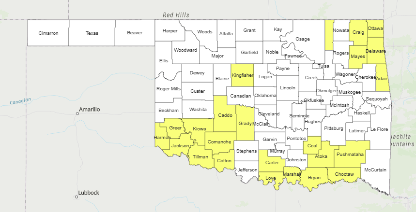
County Burn Bans: Click HERE for the most current burn ban information


