

To view the latest Oklahoma drought map, CLICK HERE.
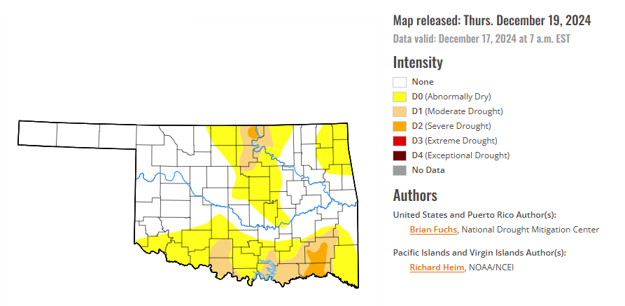
According to the latest Oklahoma drought monitor report, exceptional drought remains at zero percent, unchanged from the start of the calendar year.
Extreme drought or worse conditions remain at zero percent, unchanged since the week of October 29.
Severe drought or worse conditions are 1.85 percent, unchanged since December 5.
Moderate drought or worse conditions decreased to 11.89 percent, down from 17.91 percent last week.
Abnormally dry or worse conditions decreased to 43.97 percent, down from 46.70 percent last week.
According to the 6-to-10-day precipitation outlook map, most of Oklahoma is leading above 40-50 percent chances of precipitation through December 28, 2024. Pockets in the southwestern panhandle and southwestern corner of the state are leaning above a 33 – 40 percent chance of precipitation, and much of the eastern edge of the state, especially in the South but excepting the North, is likely above a 50 – 60 percent chance of precipitation through that December 28 date.
To view the United States Drought Map, CLICK HERE.
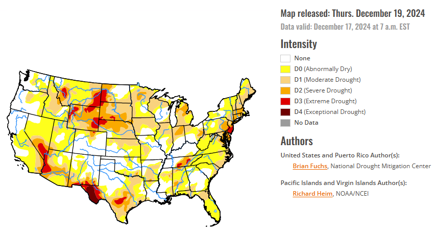
Over the last week, precipitation was greatest in portions of the Southeast and coastal areas of northern California. Widespread precipitation was recorded from Arkansas into the Midwest and along much of the eastern seaboard from the Mid-Atlantic up into New England. Much of the Plains, Southwest, and Rocky Mountains were quite dry during this period as well as much of the Florida peninsula. Temperatures were cooler than normal over the northern Plains and much of the Midwest with departures of 5-10 degrees below normal. Above normal temperatures were recorded over the northern Rocky Mountains, the southern Plains and into the South, where departures were 5-10 degrees above normal. Most other locations observed temperatures near normal.
In the Southern Plains, temperatures were warmer than normal over most of the region with departures of 5-10 degrees above normal for the week. The wettest areas were in eastern Oklahoma, Arkansas and northern Mississippi, where most recorded 150-200% of normal precipitation for the week. Moderate drought and abnormally dry conditions improved over much of northern, western, and central Arkansas and in far eastern Oklahoma. Moderate drought improved over extreme southeast Mississippi and in far eastern Tennessee. Portions of eastern Tennessee continued to be dry and a new pocket of extreme drought was added. Exceptional drought was removed from south central Tennessee and some improvements to moderate drought and abnormally dry conditions were made in central Tennessee. Moderate drought expanded in east Texas while severe drought contracted in north Texas and portions of east Texas.
In The High Plains, it was a dry week for most of the region with only areas of southeastern Nebraska, northeastern Kansas, northern North Dakota and the Plains of eastern Wyoming and Montana showing any above-normal precipitation. Temperatures were cooler than normal over the Dakotas with departures of 3-6 degrees below normal while most of the rest of the region was 3-6 degrees above normal for the week. Abnormally dry conditions improved over southwest and southeast Kansas while severe drought improved in northeast Wyoming and into western South Dakota. The extreme drought in northeast Nebraska was reassessed and removed as the convergence of the indicators at extreme drought levels no longer existed, even with some long-term signals still showing some dryness in the extreme levels.
In the West, most of the southern and southwest portions of the region were dry for the week. After an early start to the snow season, many areas have seen it drop off considerably and are below normal for this time of year. The wettest areas were in northern California into the Great Basin and southern Idaho and Montana. Temperatures were mainly 3-6 degrees above normal over the region with only those areas recording the most rains being below normal for the week. Even with the precipitation in areas, changes to the drought status in the region were minimal this week. Moderate drought improved in northern Utah and southwest Wyoming. Extreme drought expanded in northwest Wyoming while northern Colorado had abnormally dry and moderate drought expand slightly.
Looking ahead, over the next 5-7 days, it is anticipated that the best chances for precipitation will be over the Pacific Northwest, Midwest, and the eastern third of the United States. Much of the central and southern Plains, Southwest, and Rocky Mountains will expect little to no precipitation. Temperatures during this period will be above normal over the western half of the country with the greatest departures expected over the Southwest where it could be 10-13 degrees above normal. The coolest temperatures will be along the East Coast where departures of 7-10 degrees below normal can be anticipated from North Carolina up to New York.
The 6-10 day outlooks show that the probability of warmer-than-normal temperatures covers almost the entire country outside of the East Coast from North Carolina to Massachusetts where probabilities lean to near normal conditions. The highest probabilities of above-normal temperatures will be in the northern Plains and upper Midwest. The greatest chances of above-normal precipitation will be in the Pacific Northwest and portions of the South. The best chances of below-normal precipitation are in the Southwest and northern New England..
To view the 6-10 Day Precipitation Outlook Map, click here.
To view the 6-10 Day Temperature Outlook Map, click here.
To view the Monthly Drought Outlook Map, click here.


