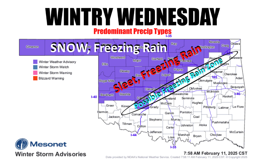
Oklahoma is bracing for a winter storm, with the northwestern half of the state facing a potential mix of snow, freezing rain, sleet, and rain. State Meteorologist Gary McManus weighed in on the impending weather, noting the double-edged nature of the situation.
“Still looking at a probable winter storm across the NW half of the state, with snow, freezing rain, and sleet all being possible. Oh, and rain, too,” McManus stated. While the rain is welcome, the frozen precipitation is less so, although he added, “amounts have definitely trended down in the last couple of days.”
McManus highlighted the conflicting impacts of the reduced moisture. “That’s a double-edged rake, right? Less moisture, less impactful wintry weather. Less moisture, less drought (or dry spell) relief.”
McManus also expressed concern about the I-44 corridor. “I’m a bit concerned about the I-44 corridor maybe getting a bit of freezing rain tomorrow morning. That’s why I have it in the ‘possible’ zone. It all depends on how far south that arctic front can make it. Of course, I’d prefer it to stay IN the Arctic, but Mother Nature does these things to irritate me.” He emphasized the unpredictable nature of arctic fronts, advising, “At any rate, it’s best to stay alert over the next 24-30 hours as things unfold because these arctic fronts have a mind of their own.”
McManus shared insights from the National Weather Service (NWS) in Norman, highlighting the freezing line’s uncertainty. “The uncertainty remains the exact location of the surface freezing line (32 deg F),” the NWS discussion stated. While models varied, the NWS noted, “the AI-based models (i.e., GraphCast GFS and ECMWF-AIFS) are appreciably colder with the freezing line 50 to 70 miles to the southeast of the I-44 corridor.” This led to the addition of several counties to the Winter Weather Advisory. “As a result, the latest 06Z NAM has trended a touch colder. Given these observations and the colder trend (and the fact colder air often advances farther south than many models forecast), we decided to add Caddo, Canadian, and Oklahoma counties to the Winter Weather Advisory as a colder trend would shift impacts farther southeast.”
McManus provided a link to the Oklahoma Mesonet, where the freezing line can be tracked in real-time. https://www.mesonet.org/weather/air-temperature/air-temperature?ref=1324
“You can track that freezing line across the state right here on the Oklahoma Mesonet, every 5 minutes!” He concluded with a touch of humor, “How about we move it north aways? Maybe 2000 miles or so?”
To read more from State Climatologist Gary McManus on his mesonet ticker, click here: