

Oklahoma has endured a brutal stretch of record-breaking cold, but relief is finally on the horizon. According to State Climatologist Gary McManus, the long-awaited thaw is set to begin this Friday. However, the journey to warmer temperatures has been a frigid one, marked by historic lows and a lingering concern for potential drought.
“25 degrees below normal, outside of summer, never looked so good!” McManus quipped, highlighting the extreme nature of the recent cold snap. But the road to that relief wasn’t without its final, icy hurdles. “But here we go again with another COLD record-breaking day. Or a record-breaking COLD day. Either way, it’s making me hot around the collar,” he added, expressing the frustration many Oklahomans felt.
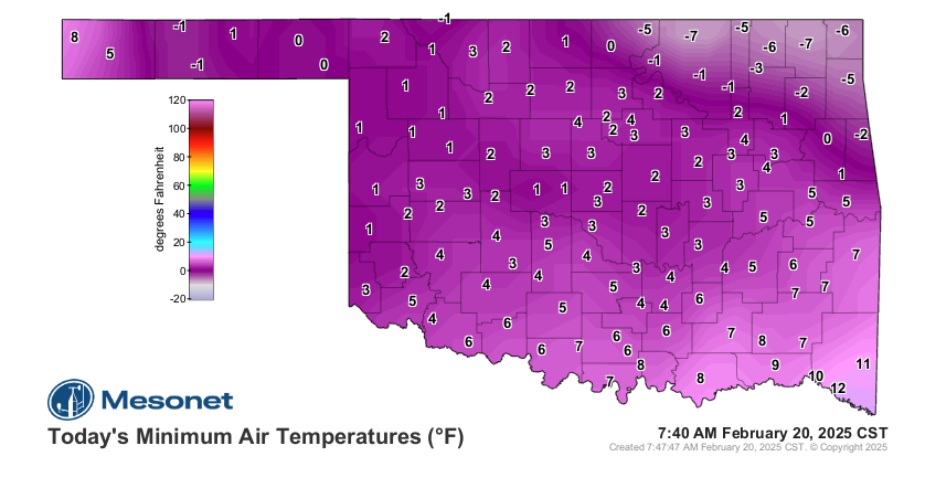
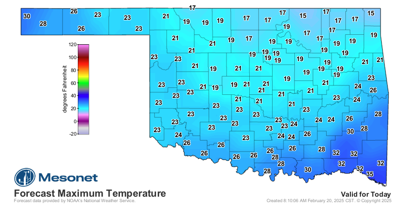
The bone-chilling conditions resulted in record-low temperatures, with Foraker and Vinita hitting a staggering -7 degrees. “In fact, if not for a somewhat suspect -12 from Upper Spavinaw Port in 2021, that -7 at Foraker and Vinita would be the lowest temperature ever recorded on a Feb. 20 dating back to the 1880s,” McManus revealed. Even today’s highs were predicted to break records, and the cold was expected to continue through Thursday morning.
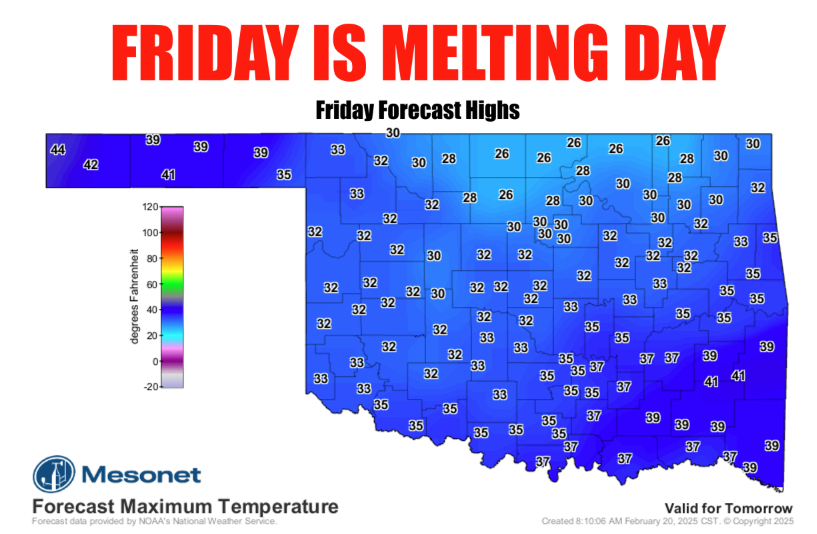
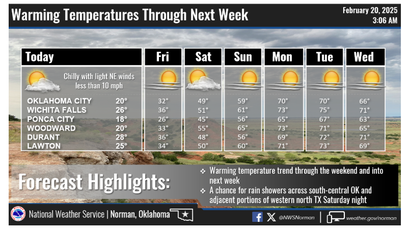
Finally, the shift is coming. “Those highs on Friday on that top map will actually be the final end of this stretch, which continues to, uhhhhhh, stretch. Friday looks manageable. Saturday not bad. Sunday good. Monday great. Tuesday? Fantastic,” McManus outlined, painting a picture of a gradual but welcome warming trend. “After this, 50s are the new 70s, so those 70s will be like 90s. Now come summer (which starts March 18th), 90s will be the new 70s.”
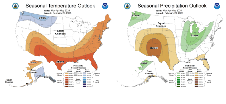
However, with the warmth comes a new set of concerns. The Climate Prediction Center’s (CPC) spring outlook paints a potentially troubling picture for western Oklahoma. “CPC’s spring outlook is none too kind for the western half or so of the state, with above normal temps AND below normal precip most likely, which then leads to drought development through that period,” McManus warned.
While the odds aren’t overwhelmingly tilted, the lingering effects of a weak La Niña are a factor. “Although impacts from La Nina and El Nino tend to dampen quite a bit during the spring season, there are often still lingering impacts. The caveat here is that it IS a weak La Nina, so the impacts are less likely to occur, with higher variability. However, those impacts are still more likely than not,” he explained.
The lack of significant precipitation in certain areas is already a cause for concern. “I know we just had widespread snow and ice, but not much across those orange areas on the map, and we do have a large part of the state in ‘Abnormally Dry’ D0 conditions on the Drought Monitor map, signaling areas in this case of being in danger of drought development,” McManus stated.
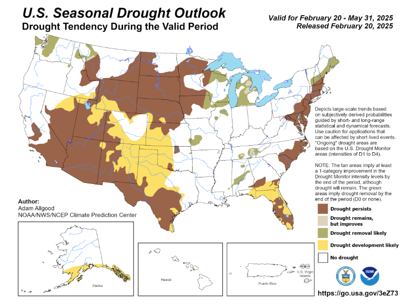
He also acknowledged the unexpected benefit of the recent extreme cold. “It might not seem like it, but we’ve been extremely lucky we’ve been so cold over the last 2 months, or drought would be sprouting like weeds,” he admitted. The solution, he emphasized, is simple: “The cure is pretty simple. Rain (or snow or ice). It does look dry through the end of February, however.”
As Oklahoma prepares to shed its icy coat, residents hope for a spring that brings warmth and much-needed moisture. Only time will tell if the state can avoid the threat of drought after enduring such a historic cold snap.
To read more from Gary McManus on his mesonet ticker, click here:


