

Oklahoma, while currently experiencing relatively low drought levels, is facing increasing dryness in the western part of the state, raising concerns about potential wildfires. Victor Murphy with the National Weather Service provided an update during the Southern Plains Climate Hub seminar, highlighting the rapid changes that can occur in the Southern Plains.
Current Drought Status:
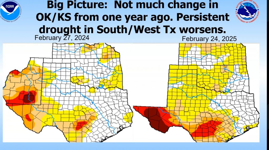
Oklahoma’s Drought Severity Coverage Index (DSCI) was at 20 this time last year, and is currently at 74 which is still a relatively low level of drought. Approximately 7.5% of the state is currently in drought, compared to only 3% at the same time last year.
“Being springtime in Oklahoma and the Southern Plains, things could change quickly,” Murphy mentioned wryly.
Growing Dryness in Western Oklahoma:
Significant dryness has been observed across Western Oklahoma over the past 30 to 60 days which has received less than half of normal precipitation over the past thirty days. This is a cause for concern for Oklahoma’s producers.
Wildfire Risk:
Despite the current low drought levels, the potential for wildfires remains a significant concern, especially as the state approaches the time of year when they are more likely. “All it takes is one significant event with the right conditions or wrong conditions, and you can have major wildfires developing,” Murphy warned.
He referenced the devastating wildfires of February 2023, where 150,000 acres were burned in Northwest Oklahoma with drought ratings near zero. “You know, as good as things we’re looking right now for Oklahoma, the wildfire danger is just right around the corner. It’s always possible if you get the right conditions.”
He highlighted the extreme conditions that fueled the 2023 fires, which included high temperatures, low humidity, and strong winds. “It doesn’t take a whole lot to get wildfires burning, and I’m sure the forestry officials of Oklahoma are keenly aware of that.”
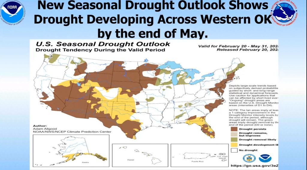
Seasonal Drought Outlook:
The Climate Prediction Center forecasts drought development across Western Oklahoma and West Texas between now and the end of May.
“As good as things are right now from a drought perspective – very little drought ongoing right now – things are forecast to take a turn for the worst in that regard,” Murphy noted.
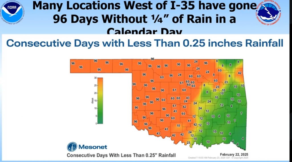
The map below indicates areas in Western Oklahoma that have gone more than 96 days without 1/4″ of rainfall, and with no rain in the forecast for the next week or so, some areas will be without significant rainfall for more than 100 days. This dryness, combined with the potential for strong winds and high temperatures, creates a heightened risk of wildfires. Residents are urged to remain vigilant and take precautions to prevent wildfires.
Below is an excerpt from the Fire Situation Report released yesterday detailing fire danger risks in each region of the state:
- Oklahoma Panhandle: Strong drying conditions through the weekend (Rh values in the teens) have resulted in increased fuel receptiveness. Today – Marginal to moderate overnight moisture recovery will set the stage for an earlier onset of active burning conditions as temperatures warm into the low- to mid-70°s under mostly clear skies with afternoon relative humidity values 15-22%. 1 Hr. fuels will tap 3% briefly in the western Panhandle while 4% observations are more likely east. Light northerly winds sustained 5-9 mph with limited gust potential will present head fire rates of spread 62-92 ft/min with flame lengths 7-10 ft offering very good probability of initial attack success. Tuesday – Moderate overnight moisture recovery is again expected ahead of temperature again warming into the mid-70°’s under clear skies with afternoon relative humidity values 16-21% yielding fine-dead fuel moisture at 4% for most locations. Light and variable winds become southerly in the afternoon remaining rather light for the area 6-11 mph (a bit higher in western Cimarron County). During peak burning conditions on established fires, rangeland fuels will support head fire rates of spread generally around 90 ft/min noting that areas with heavier fuel loading will likely express ROS +/-125 ft/min and FL 9-12 ft.
- Western Oklahoma: It is anticipated that prescribed fire activity will ramp up early in the week ahead of a frontal boundary on Wednesday coupled with an uptick in initial attack activity. Today – following a cool start and moderate overnight moisture recovery, temperature will warm into the 74° (north) to 79° (south) range under mostly-clear skies with afternoon relative humidity values 12-22% prompting intensified drying and yielding fine-dead fuel moisture at 3-4%. Light winds this morning will become southwesterly to variable in direction this afternoon sustained 4-9 mph limiting fire spread potential. Grass-dominated rangeland fuels will support head fire rates of spread generally +/-85 ft/min noting that heavier fuel loadings on far western Oklahoma may support ROS nearer to 100 ft/min and flame lengths 10-12 ft. Tuesday – Following moderate overnight moisture recovery, afternoon temperatures will again register in the mid-70°s under mostly clear skies with relative humidity values 21-28% yielding 1-Hr fuel moisture at 4-5%. Variable winds in the AM will become southeast sustained 7-12 mph gusting to 17 in the afternoon. Rangeland fuels will exhibit head fire rates of spread 80-120 ft/min with flame lengths +/-10 ft.
- Central Oklahoma: Initial attack will increase this week and scouting of engine access is merited given areas wet ground limiting rubber-tire vehicle access. Today – Good overnight, moisture recovery will stall the development of active burning conditions until the afternoon, when drying conditions settle in. Temperature will warm into the 70-74° range under clearing skies with afternoon relative humidity values 21% (west) to 35% (east) yielding fine-dead fuel moisture at 5-6%. Southwest to west winds sustained 5-9 mph with limited gust potential will hold grassland rates of spread to under 110 ft/min and
flame lengths +/- 10 ft. Very good overnight moisture recovery will again stall active burning conditions on Tuesday before temperatures again warm into the 70°s with afternoon relative humidity values 26-37% yielding 1-Hr fuel moisture at 6-7%. Light and variable winds in the AM will become southeasterly in the afternoon sustained 6-11 mph. Head fire ROS in grass-dominated fuels at +/- 95 ft/min and FL around 9 ft. should be anticipated during peak burning conditions. - Eastern Oklahoma: Today – Good overnight moisture recovery and lingering scattered sky cover will serve to stall active burning conditions until later this afternoon. Temperature will warm into the mid-60°s to low-70°s with afternoon relative humidity values 30-41% and fine-dead fuel moisture at 7%. Southwest winds sustained 4-9 mph will limit fire spread potential overall. Grass-dominated fuels will support head fire rates of spread topping out around 100 ft/min with flame lengths 10-12 ft. while timber-litter will retain elevated moisture limiting fire behavior. Timber-litter will likely support max head fire ROS +/-18 ft/min and FL 4 ft. On Tuesday, active burning conditions will again be stalled with good overnight moisture recovery prior to temperature warming into the 70°s with afternoon relative humidity values 30-42% and 1-hr fuel moisture at 6-7%. Light and variable winds will remain rather light through the afternoon becoming southerly sustained 3-6 mph. Fire spread potential will be hampered by the low wind speeds facilitating very good initial attack success opportunity.
Outlook: A frontal boundary is expected to slide across Oklahoma on Wednesday. Temperatures will be just a bit cooler than Tuesday although north winds will increase, especially in the western one-third of the state where winds sustained around 20 mph and gusts near 30 mph will challenge control lines from fire activity on Monday and Tuesday. Rangeland fuels will support more rapid rates of spread nearer to 250 ft/min (2.8 mph) on fully established fires where continuous, heavy-load fuel is present. While large fire potential is in the mix, significant fire potential continues to remain low. Energy Release Component has remained below
the 70th Percentile through February, although by Wednesday afternoon we are expecting to see those values creep into the 70th percentile range in southwestern Oklahoma. ERC values above the 70th percentile point to increasing resistance to control and longer duration of firefighting resources to fully contain wildfires.
Fire danger indices will continue to ratchet up each day through Friday ahead of the next chance of meaningful precipitation late in the weekend/early next week. Will this rainfall opportunity break the current stretch of dryness in the west, remains in question. The Percent of Normal Rainfall since December 1, 2024, will require an extended period of wetting rainfall to sway the current building dryness on the landscape. The current U.S. Seasonal Drought Outlook points to ‘Drought Development Likely’ coupled with an increasing concern for significant fire potential later in March.
To view the latest Oklahoma Drought Monitor Report published last Thursday, click here.


