Statewide Discussion: Solidly wetting rains occurred at most locations across the southern half of Oklahoma, providing both amount and duration, boosting composite fuel moisture. Fire weather this week will drive escalating fire danger ahead of a potent storm system arriving on Friday. Wildfire activity is expected to increase through the week with a warming trend and drying conditions. Large and significant wildfire potential is anticipated, coupled with the increasing probability of a Southern Great Plains Wildfire Outbreak with Friday’s weather system. Prescribed and controlled burning is also expected to increase in frequency early in the week, and practitioners are strongly encouraged to ensure thorough mop-up and extended periods of patrol.
Unfortunately, most of the northern half of Oklahoma did not receive the precipitation that occurred further south, and by Tuesday afternoon, Energy Release Component will have eclipsed the 80th Percentile, resulting in significant resistance to control. Initial attack activity is expected to increase steadily this week with increasing large fire potential (>300 Acres) building to significant fire potential (>5,000 Acres) Friday.
Today: Warmer weather with a much drier airmass will overspread Oklahoma today as dry-return flow becomes established. Southwest winds coupled with relative humidity values less than 30% over the bulk of the state will enhance drying in the northern half of the state where wetting rains did not materialize and initiate drying at points along and south of I-40. Wildfire activity will be muted in the south while increasing in frequency north, where receptive fuels reside coupled with degrading composite fuel moistures leading to resistance to control. Overall, initial attack activity is expected to be successful, and prescribed fire practitioners are encouraged to complete thorough mop-up given the anticipation of escalating fire danger this week.
- Northern/Northeastern Oklahoma: Temperature will warm into the mid- to upper-70°s under clear skies with afternoon relative humidity values 15-22% yielding receptive fine-dead fuel moisture at 4% at most locations. Light winds this morning will become southwest sustained 9-16 mph with some gusts over 20 mph (especially north-central). Native, grass-dominated fuels will exhibit head fire rates of spread 120-170 ft/min and flame lengths 11-17 ft. Mixed-fuels will exhibit ROS +/-40 ft/min and FL 8-10 ft. Timber-litter further east will present ROS +/-20 ft/min and FL 3-5 ft. The probability of successful initial attack remains good with limited large fire potential.
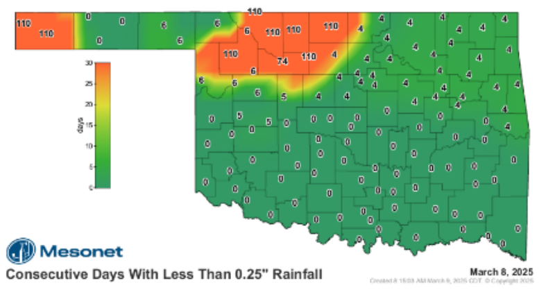
- Oklahoma Panhandle/Northwest Oklahoma: A few locations in the Oklahoma Panhandle did accumulate wetting rainfall amounts – barely – which will largely be overcome with very strong drying conditions today. A significant portion of northwest Oklahoma continues to add to the days since wetting rain that now sits at 111 days for a sizeable area. Today, following a chilly start, the temperature will warm into the 74°-80° range under clear skies with afternoon relative humidity values 7% (Cimarron County) to 20% further east with most locations registering around 15% this afternoon. Fine-dead fuel moisture will become very receptive at 3% this afternoon, supporting active fire behavior. Southwest winds sustained 13-18 mph with some higher gusts will support moderate to rapid rates if fire spread. Rangeland fuels will exhibit head fire rates of spread 130-200 ft/min and flame lengths 11-15 ft during peak burning conditions, while shorter-stature grass loadings will support RO +/-95 ft/min and FL 6-10 ft. Initial attack efforts will likely prove challenging, and large fire occurrence cannot be ruled out.
- Western/Southwestern Oklahoma: Wetting rainfall south of I-40 on Saturday will serve to improve composite fuel moisture and prompt a flush of greening in cool-season grasses offering some opportunities on the fireground although warm/dry conditions will rapidly bring dormant grass loadings back into play. Temperature 72°-79° under clear skies and relative humidity values this afternoon 20-29% will offer fine-dead fuel moisture at 5% across the area. Southwest winds sustained 9-15 mph with some higher gusts this afternoon will support head fire rates of spread in prevalent rangeland fuels at 85-130 ft/min with flame lengths 7-11 ft. The probability of a successful initial attack is very good, although areas of wet ground will hamper or prohibit engine access in many areas.
- South-Central/Southeastern Oklahoma: Wetting rainfall has improved composite fuel moisture, decreasing resistance to control. Grass-dominated fuels will come back online for burning today while timber-litter and brush fuels will likely serve as a heat sink on the fireground. Under clear skies, temperature will warm into the low- to mid-70°s coupled with afternoon relative humidity values 24-34% yielding fine-dead fuel moisture at 6% across most of the area. Southwest winds sustained 5-10 mph with limited gusts will yield manageable rates of fire spread noting that suppression efforts will likely be complicated by wet ground limiting access for engines and equipment. Grass-dominated fuels will exhibit ROS generally less than 95 ft/min and FL 6-9 ft. Timber-litter will struggle to exceed ROS of 20 ft/min offering very good probability of a successful initial attack.
- Outlook: Overnight moisture recovery will be, at best, moderate tonight supporting accelerated drying of wildland fuels into midweek. A mid-week disturbance has potential for some rain chances in southeastern Oklahoma Wednesday, otherwise, dry conditions are expected. By Thursday, fuels across the western and northern counties will support escalating fire behavior potential coupled with worsening resistance to control. A potent storm system on Friday is poised to bring Very-High to Extreme Fire Danger indices supporting potential for a Southern Great Plains Wildfire Outbreak. Current forecast data emphasizes the threat across northern and western Oklahoma.
County Burn Bans: None – Click HERE for current burn ban information.