

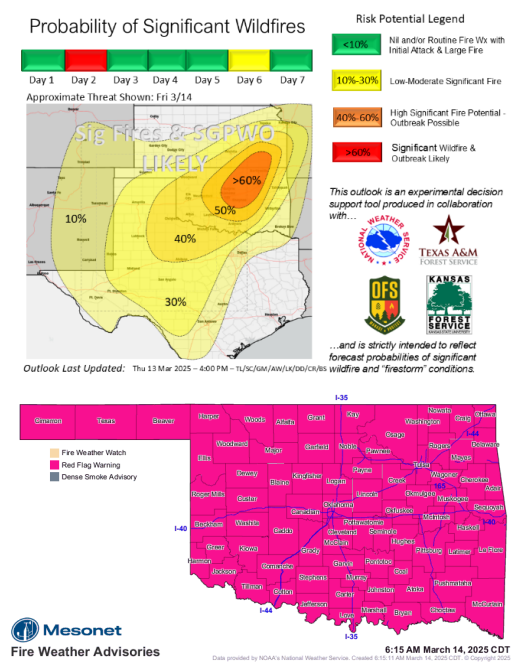
Statewide Discussion: Fire behavior on any wildfire today will likely exhibit very-rapid to extreme rates of fire spread and prove highly resistant to control with accelerated drying in recent days. We have updated the probability of significant fire occurrence map to reflect the most current weather and wildland fuels inputs upgrading to ‘High Significant Fire Potential – Outbreak Possible’ for a portion of the state extending from the Oklahoma City Metro to the Tulsa Metro including locations along I-44. Rates of fire spread on fires established in tall-grass and rangeland fuels will move 2.5 to 6 mph (faster in some cases) while extreme fire behavior including torching, spotting and crown fire will be
observed on established fires.
Firefighters should avoid frontal assault as fires will likely outpace suppression capacity. Instead, establish an anchor point near the heel of the fire flanking the fire edge progressing toward the head fire. Dedicate resources to protect values at risk when possible maintaining escape routes to safety zones.
Today: Red Flag Warning in effect for all 77 counties in Oklahoma today. The highest level of fire environment factors (weather, fuels, topography and values at risk) will be focused on north-central and northeastern Oklahoma today. Truthfully, this is a matter of gauging the level of extreme as the entirety of Oklahoma will experience extreme fire behavior indices and likely witness that potential. The length of the critical burning period today, or when rates of fire spread +/-3 mph will range from 5-10 hours indicating that fires exceeding 5,000 acres are likely and potential for a Wildfire Outbreak or possibly a Firestorm is present.
A dryline will drive across the state from west to east today resulting in afternoon relative humidity values less than 20% nearly statewide. The dryline will be followed by a dry cold front will enter far northwestern Oklahoma later this afternoon with winds shifting from southwest to northwest pushing the east flank of any going fire driving rapid fire growth potential. Winds will decrease to some extent later in the overnight period although only modest overnight moisture recovery will result in a very extended burning period ahead of near-critical fire weather over readily receptive fuels tomorrow.
OFS Resources Outside of OFS Protection: Resource Hotline (800) 800-2481
- Guthrie – Suppression Group
- Weatherford – Suppression Group
- Woodward – Suppression Group
- Burns Flat – Aerial Supervision Module and 2 CL415 Scoopers Winds will likely prohibit firefighting aviation today
Fire Behavior:
Northern/Northeastern Oklahoma: Historic fire environment conditions will develop around midday persisting well into the evening hours with extreme fire expected on any established wildfire. Temperature 69°-77° under a few clouds and potentially dust coupled with afternoon relative humidity values 11-16% will yield very receptive 1-Hr fuel moisture at 3%. 4% observations may occur if dust shades the fuels. Winds will increase into midday with southwest winds sustained 24-34 mph gusting 40-65 mph. Grass-dominated and rangeland fuels will exhibit dangerous fire behavior with rates of spread 290-450 ft/min (3.2 – 5.1 mph) with flame lengths 15-22 ft. Firefighters should anticipate extreme fire behavior in mixed and timber fuels with group torching, spotting to 0.5 miles and crown runs in brush an juniper fuels. Based on current forecasts, the cold front will arrive during the overnight hours.
Northwestern/Oklahoma Panhandle): Partly cloudy to mostly clear skies with dust expected will provide some fuel shading, although temperatures 60°-68° coupled with afternoon relative humidity values 12-22% will yield receptive fine-dead fuel moisture at 3-4%. An approaching cold front will likely be over the area during peak burning conditions with southwesterly winds becoming wet then northwest sustained 29-40 mph gusting to 65 mph. Rangeland fuels will support rates of fire spread 305-505 ft/min (3.4-5.7 mph) and flame lengths 16-22 ft. Mixed fuels (grass/brush) will exhibit ROS 130-170 ft/min and flame lengths +/-14 ft with torching and moderate-range spotting likely. With the frontal boundary a slight chance of isolated shower will be present through a portion of the day.
Western/Southwestern Oklahoma: Critical fire weather will develop early in the burning period persisting well into the
overnight hours. A cool start with marginal overnight moisture recovery will transition temperature in the upper-60°s to low70°s and afternoon relative humidity values 9-15% with 1-Hr fuel moisture at 3% across the area noting that a 2% observation is possible. Dust in the air will providing some fuel shading, although any fire that becomes established will be subjected to a lengthy period of extreme fire behavior. Southwesterly winds sustained 29-40 mph with some gusts to 65 mph will drive extreme rates of fire spread on any established fire. Rangeland fuels will exhibit head fire rates of spread 350-540 ft/min (3.9-6.1 mph) during peak burning conditions with flame lengths 16-23 ft. Short grass will offer slightly reduced rates of spread and firefighters are encouraged to use heavily grazed areas or wheat fields as opportunities on the fire environment.
South-Central/Southeastern Oklahoma: Recent fire activity will be subjected to anomalous fire weather today and any fire on the landscape will exhibit potential for extreme rates of spread and rapid transition to extreme fire behavior especially where pine and/or juniper species are present. Temperature 74°-84° under mostly-clear skies with afternoon relative humidity values 10-19% will yield very receptive fine-dead fuel moisture at 3-4%. Calm winds this morning will become southwest-sustained 19-28 mph, gusting 30-45 mph, supporting extreme rates of fire spread. Grass-dominated fuels will exhibit head fire ROS at 220-320 ft/min (+/-3 mph) with FL up to 17 ft. Mixed fuels ROS +/-150 ft/min with FL 12 ft should be anticipated. Extreme fire behavior in the pine-dominated fuels is likely on any established wildfire, including group-torching, crown fire runs, and spotting to 0.75 mi. ROS in those pine stands will have the potential to be 160 ft/min with an average FL 17 ft. Conditions will persist after sunset, gradually calming a bit in the early morning hours.
Outlook: There is no immediate relief in sight to building fire danger concerns continuing after today. While the strength of fire weather will slightly relax Saturday and Sunday, indices rapidly increase Monday and Tuesday when widespread critical fire weather is again expected across most of Oklahoma. Energy Release Component values, or composite fuel moisture, continue to decrease, translating to less critical fire weather supporting potential for problematic or extreme fire behavior.
County Burn Bans: Click HERE for current burn ban information


