

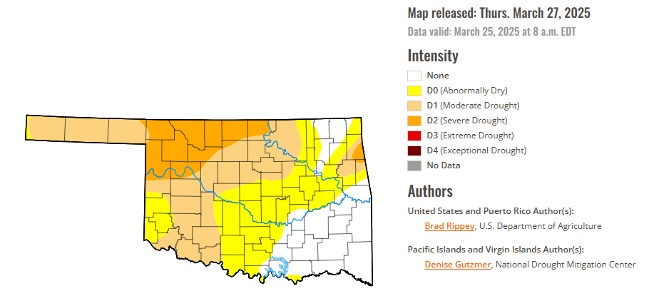
To view the latest Oklahoma drought map, CLICK HERE.
According to the latest Oklahoma drought monitor report, exceptional drought remains at zero percent, unchanged from the start of the calendar year.
Extreme drought or worse conditions remain at zero percent, unchanged since the week of October 29, 2024.
Severe drought or worse conditions have increased to 14.10 percent, up from 13.6 percent last week.
Moderate drought or worse conditions have increased to 47.52 percent, up from 42.48 percent last week.
Abnormally dry or worse conditions have increased to 76.95 percent, up from 73.22 percent last week.
According to the 6-to-10-day precipitation outlook map, the majority of Oklahoma is leaning above a 33-40% chance of precipitation through April 5. Only the Northwestern corner of the state is leaning above a 33-40 % chance of precipitation through that April 5 date.
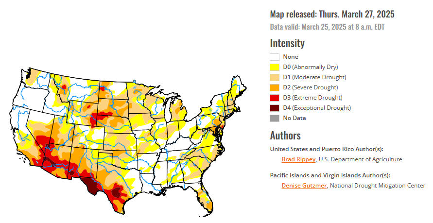
To view the United States Drought Map, CLICK HERE.
On March 18—for the second time in 5 days—a ferocious dust storm across the southern High Plains and neighboring regions led to sharp visibility reductions and increasingly stressful conditions for rangeland, pastures, and winter grains. The dust, lofted by high winds, was drawn into a storm system crossing the central Plains and upper Midwest, leading to widespread reports of “dirty” rain and snow. On March 19-20, significant accumulations of wind-driven snow occurred from parts of Kansas and Nebraska into northern Michigan, while locally severe thunderstorms erupted across the Midwest. More than a dozen tornadoes were spotted on March 19 across Illinois and Indiana. Farther east, however, parts of the Carolinas experienced a rash of spring wildfires, with the Black Cove and Deep Woods Fires near Saluda, North Carolina, collectively charring some 6,000 acres of vegetation and destroying at least 20 structures. Some of the fuel for fires in the Carolinas was provided by trees downed by Hurricane Helene about 6 months ago. Elsewhere, dry weather dominated the southern Plains and the Southwest, while late-season precipitation fell in northern and central California and the Northwest. According to the California Department of Water Resources, the average water equivalency of the high-elevation Sierra Nevada snowpack climbed nearly to 25 inches, essentially ensuring a normal seasonal accumulation. For the second week in a row, near- or below-normal temperatures dominated the West, although warmer weather arrived late in the drought-monitoring period. Conversely, warm weather prevailed in many areas east of the Rockies, with consistently chilly conditions limited to portions of the nation’s northern tier.
In the Southern Plains, drought-related impacts further spread and intensified across parts of Texas and Oklahoma, amid March winds, dust, and dryness. In fact, two previously separate areas of drought were connected across Texas and Oklahoma. Meanwhile, little rain has fallen since mid-February across Arkansas and portions of neighboring states. While the short-term dryness has been favorable for spring fieldwork, rain will soon be needed across the mid-South for pastures, fall-sown small grains, and recently planted summer crops. By March 23, nearly one-half (46%) of the intended rice acreage had been planted in Louisiana, along with 36% in Texas. In Arkansas, 10% of the corn and 2% of the rice had been planted by March 23, while 7% of the winter wheat had headed. Pastures in Arkansas—rated 27% very poor to poor on March 23—were just starting to exhibit some stress from short-term dryness. On that date, rangeland and pastures in Texas were in much worse shape (71% very poor to poor), reflecting drought at multiple time scales and the impact of recent blowing dust.
In the High Plains, major storm systems continued to “undercut” the Dakotas and portions of neighboring states. Notably, severe drought (D2) was broadly expanded in South Dakota, where season-to-date snowfall totals were broadly at least 1 to 2 feet below average. With the northern Plains’ drought occurring at multiple time scales, current impacts include poor conditions for rangeland, pastures, and winter wheat. In contrast, late-season storminess across the northern Intermountain West, including much of northern and western Wyoming, led to improved mountain snowpack, more favorable spring and summer runoff prospects, and reductions in drought coverage and intensity.
In the West, occasional precipitation continued to fall across roughly the northern half of the region, further improving high-elevation snowpack, as well as spring and summer runoff prospects. Drought improvements of up to one category were introduced from the northern Great Basin to the northern Rockies. Meanwhile, dry weather returned across the Southwest, following some late-season precipitation that was heaviest in parts of southern California but did not reach the southern Rockies. In fact, significant increases of all drought categories were introduced in New Mexico, parts of which have been affected by the same windy, dusty weather that has been plaguing the southern Plains.
Looking ahead, Drought-easing rain across southern Texas will gradually shift eastward along the Gulf Coast. Five-day rainfall totals could reach 2 to 8 inches or more across the western half of the Gulf Coast region, with higher totals leading to flooding in southern and coastal Texas. Meanwhile, active weather will also prevail in the vicinity of a nearly stationary front draped across the northern United States. The front will separate cold air to the north from warmth farther south, with accumulating snow expected during the weekend from parts of the northern Plains eastward into northern New England. Meanwhile, Midwestern 5-day rainfall could total 1 to 2 inches, accompanied at times by locally severe thunderstorms. Elsewhere, persistent low pressure near the northern Pacific Coast will maintain showery, unsettled conditions from the Northwest to the northern Rockies, while mostly dry weather will persist in the Southwest, despite a cooling trend.
The NWS 6- to 10-day outlook for April 1-5 calls for above-normal precipitation nearly nationwide, with northern and central California and the western Great Basin having the greatest likelihood of experiencing wet conditions. Elevated odds of near- or below-normal precipitation should be limited to southern Texas. Meanwhile, warmer-than-normal weather from the southern half of the Plains to the middle and southern Atlantic Coast should contrast with below-normal temperatures in the Far West and across the nation’s northern tier. The likelihood of near- or below-normal temperatures in northern California and the Pacific Northwest, along with portions of the Great Lakes and Northeastern States. Warmer-than-normal conditions will cover the remainder of the country. Meanwhile, wetter-than-normal weather nearly nationwide should contrast with near- or below-normal precipitation across southern sections of the Rockies and High Plains, along with the Rio Grande Valley.
To view the 6-10 Day Precipitation Outlook Map, click here.
To view the 6-10 Day Temperature Outlook Map, click here.
To view the Monthly Drought Outlook Map, click here.


