

To view the latest Oklahoma drought map, CLICK HERE.
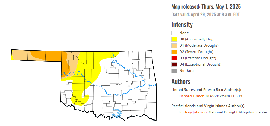
According to the latest Oklahoma drought monitor report, exceptional drought remains at zero percent, unchanged from the start of the calendar year.
Extreme drought or worse conditions remain at zero percent, unchanged since the week of October 29, 2024.
Severe drought or worse conditions have increased to 6.91 percent, up from 2.74 percent last week.
Moderate drought or worse conditions have decreased to 14.14 percent, down from 32.02 percent last week.
Abnormally dry or worse conditions have decreased to 33.14 percent, down from 46.00 percent last week.
According to the 6-to-10-day precipitation outlook map, the western half of the state of Oklahoma is leaning above a 40-50% chance of precipitation, and the eastern half is likely above a 50-60% chance of precipitation through May 10. The extreme southwest corner of the panhandle is likely above a 60-70% chance of precipitation and the far northeast corridor is leaning above a 33-40% chance of precipitation through that May 10th date.
To view the United States Drought Map, CLICK HERE.
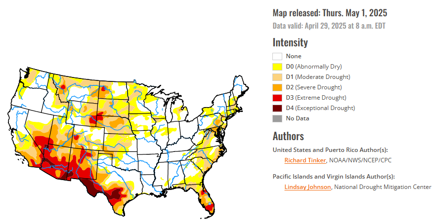
Strong thunderstorms and heavy precipitation again affected parts of the central and eastern Contiguous United States, although coverage was spotty in all but a few areas. Heavy to excessive rains (at least 2 inches) doused portions of the Plains, Mississippi Valley, Upper Southeast, and scattered to isolated sections of the northern and western Great Lakes, Ohio Valley, Carolinas, Northeast, and northern Rockies. In several sizeable areas of the Plains where there was relatively solid coverage of heavy precipitation, conditions improved significantly. Meanwhile, rainfall was negligible (several tenths of an inch at best) in most areas from the Rockies westward and in a few areas farther to the east, including much of southern and western Texas, the Oklahoma Panhandle, southeastern Kansas, central and western Nebraska, central and western North Dakota, a band from parts of the middle Mississippi Valley through the southern and eastern Great Lakes region, much of the immediate Gulf Coast, central North Carolina, central and eastern Virginia, and most of Florida and adjacent southeastern Alabama and southern Georgia. This led to another week with significant dryness and drought expansion and deterioration in the latter areas of the Southeast.
In the Southern Plains, the heaviest rain in the Contiguous United States fell on a band from central Oklahoma southwestward across the Red River (south) into part of northwestern Texas. An area covering several counties recorded 4 to locally 8 inches of rain. Lesser but still heavy amounts (over 2 inches) fell on many areas across the rest of northern, central, and eastern Texas, portions of Louisiana and Mississippi, part of southern Tennessee, and a few scattered locations across Arkansas. Rainfall during the current and past few weeks led to large areas of improvement across the central, northern, and eastern portions of the Texas dryness and drought coverage, in addition to north-central Oklahoma and the western portions of the state outside the Panhandle. Dryness and drought remains widespread across most of Texas outside the northeast and over western portions of Oklahoma, with some deterioration to D2 (severe drought) noted in the Oklahoma Panhandle, which missed the week’s heavy rains. A broad area of exceptional drought (D4) remained entrenched across a large swath in central and western Texas, though there was some erosion of its eastward extent. East of this area of solid drought coverage, most areas are free of dryness and drought, and locally heavy rains reduced the coverage even further in part of southeastern Mississippi. Small, isolated areas of abnormal dryness (D0) elsewhere were limited to northwestern Mississippi and eastern Tennessee. Arkansas is entirely free of any dryness or drought.
In the High Plains, precipitation totals varied significantly this week, but more areas were hit by heavy rains and improving conditions than dryness and deterioration. The dry week led to deterioration across southwestern Kansas, southeastern Colorado, and much of the central tier of Colorado. Further north and east, however, widespread heavy rains were noted in several swaths of the Plains and Wyoming, leading to reductions in the intensity and extent of dryness and drought. Improvements were most widespread across central and northwestern Kansas, and most of the state of South Dakota, where heavy rains were most widespread. Still, despite the improvement in many areas, 60-day precipitation totals were under 25 percent of normal in southwestern Kansas and southeastern Colorado, with less than half of normal reported in adjacent areas plus parts of central Kansas, central and northeastern Nebraska, and a few other scattered areas..
In the West, a band of moderate to heavy precipitation (1 to 3 inches) fell across southeastern and south-central Montana, plus isolated spots in eastern Idaho. The rest of the West Region was dry this past week, outside a narrow corridor of heavy rain in east-central New Mexico. As a result, dryness and drought eased their grip in these areas. In addition, some limited improvement was brought into northern and western Washington, and small parts of northern Montana, based on a reassessment of conditions. Most observed changes, however, were for the worse. Conditions were broadly downgraded across interior northern Montana, and increasing moisture deficits led to the expansion of D0 (abnormal dryness) into southwestern Washington and much of northwestern Oregon. In addition, surface moisture depletion has become increasingly obvious across several areas in New Mexico, leading to a significant increase in D3 (extreme drought) coverage there. The dryness was more climatologically seasonable across Arizona, Nevada, and California, where conditions were unchanged this week.
Looking ahead, during May 1-5, 2025, heavy rain (2 to locally 5 inches) is forecast for central and northeastern Texas, northern Louisiana, and southern Arkansas. Moderate to locally heavy totals (1 to 2.5 inches) are expected over much of Mississippi and Alabama, the central and southern Appalachians, the middle and upper Ohio Valley, Pennsylvania and adjacent New York and New Jersey, and a small portion of the central Great Lakes. Light to moderate totals (a few tenths to locally over an inch) is expected across the remainder of the eastern Contiguous United States, with the lowest amounts expected across coastal South Carolina, most of Georgia, and the northern and western sections of the Florida Peninsula. Several tenths to an inch are also forecast from the central and southern Plains westward through much of the Rockies, Nevada, and most of California, with locally higher amounts in some higher elevations of the Sierra Nevada and Great Basin. Little or none is forecast across the northern tier from the upper Mississippi Valley westward to the Pacific Coast, and in some climatologically drier parts of the Southwest. Warmer than normal weather is expected from the western Great Lakes through the northern Rockies and Intermountain West, with daily highs averaging 10 to 13 deg. F above normal in the northern Plains and adjacent areas. Meanwhile, cooler-than-normal conditions are anticipated from central and southern California through the Great Basin, southern Rockies, and central and western Texas. Highs are expected to average 8 to 10 deg. F below normal from western Texas through portions of the Great Basin and central through southern California.
The Climate Prediction Center’s 6-10 day outlook valid May 6-10, 2025 favors subnormal precipitation across the Great Lakes, middle and upper Mississippi Valley, the Ohio Valley, the interior Southeast, the mid-Atlantic region, the lower Northeast, and western New England. In contrast, enhanced chances for wetter than normal conditions cover Florida and the immediate southern Atlantic Coast, the Gulf Coast, the lower Mississippi Valley, the central and southern Plains and Rockies, most of the Great Basin, the Southwest, southeastern portions of Alaska, and Hawaii. Higher than normal temperatures are favored across roughly the northern two-thirds of the Contiguous United States, with odds exceeding 70 percent in the northern Plains and adjacent Mississippi Valley. Enhanced chances for warmer-than-normal weather also extend across Hawaii, especially central and western parts of the island chain. Increased odds for subnormal temperatures cover Florida, central and western Texas, the central and southern Four Corners region, and southeastern Alaska. Chances for significantly cooler than normal conditions exceed 50 percent across central and southern New Mexico.
To view the 6-10 Day Precipitation Outlook Map, click here.
To view the 6-10 Day Temperature Outlook Map, click here.
To view the Monthly Drought Outlook Map, click here.


