

To view the latest Oklahoma drought map, CLICK HERE.
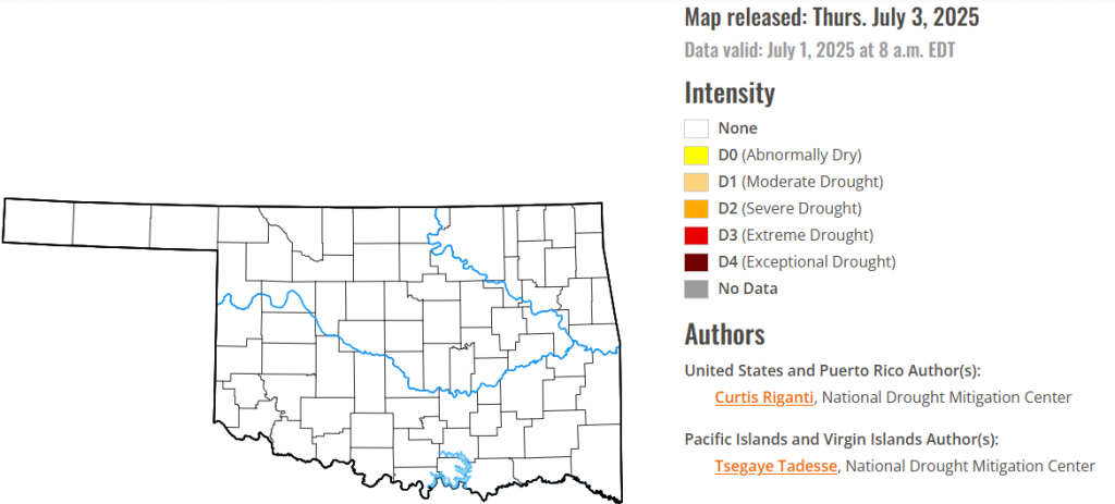
According to the latest Oklahoma drought monitor report, exceptional drought remains at zero percent, unchanged from the start of the calendar year.
Extreme drought or worse conditions remain at zero percent, unchanged since the week of October 29, 2024.
Severe drought or worse conditions remain at zero percent, unchanged since the week of May 29, 2025.
Moderate drought or worse conditions remain at zero percent, unchanged since last week.
Abnormally dry or worse conditions also stayed at zero Percent, same as last week.
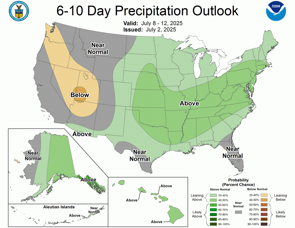
According to the 6-to-10-day precipitation outlook map, most of the state of Oklahoma is is leaning above 40-50% chance of precipitation through july 12. The panhandle has a 33-40% chance of rain through that same date.
To view the United States Drought Map, CLICK HERE.
Over the past week, scattered heavy rains fell over parts of the central Great Plains and Upper Midwest. Rain amounts were especially heavy in parts of Nebraska and Minnesota, where locally 8 or more inches of rain fell. These rains helped to alleviate drought and abnormal dryness in some areas. A few areas of the Dakotas, Minnesota, Indiana and Illinois that missed heavier rains saw localized degradations. Heavy monsoonal rain and thunderstorms also occurred in parts of west Texas and New Mexico, leading to some improvements to ongoing drought and abnormal dryness there. Meanwhile, most areas west of the Continental Divide remained dry or mostly dry. This continued dry weather led to further degradation in drought and abnormal dryness, especially in the Northwest, where severe and extreme drought developed or expanded in coverage. Conditions in the Southeast and central Gulf Coast were mostly quiet this week, though a few areas in east Tennessee and southern Louisiana saw localized abnormal dryness develop given short-term precipitation deficits and declining soil moisture. Heavier rains fell across parts of Florida, leading to some reduction in drought and abnormal dryness coverage in the Florida Peninsula. Well-above-normal temperatures occurred in the Ohio Valley, Mid-Atlantic and Lower Great Lakes regions, where temperatures ranging from 4-8 degrees above normal, and locally 10 degrees hotter than normal, were common. The Northwest was also warmer than normal this week, with most areas checking in with warm anomalies of 2-6 degrees. Southeast New Mexico and west Texas finished the week 2-8 degrees cooler than normal owing to rain and clouds from the North American Monsoon, which became much more active this week.
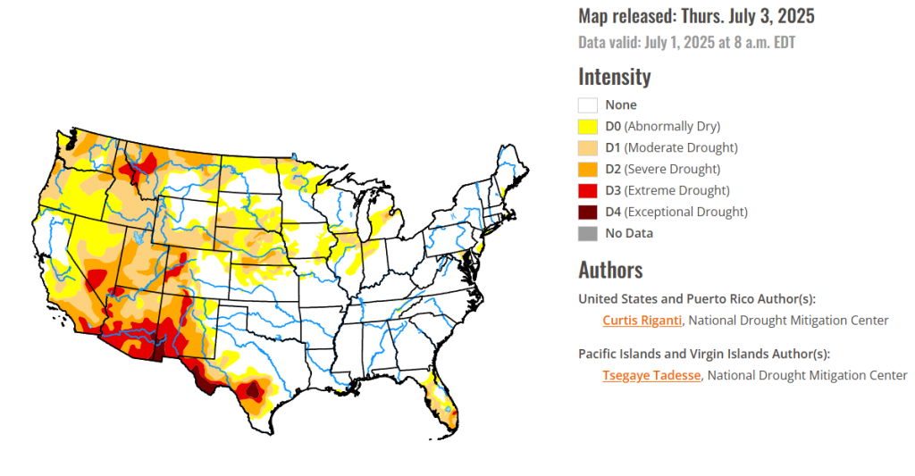
In Hawaii, A mix of improvements and degradations occurred across Hawaii, where vegetation and streamflows responded to recent rainfall or lack thereof.
In Alaska, Scattered heavier showers fell across parts of Alaska, while some locations that missed out saw fire danger increase, leading to a mix of improvements and degradations.
Puerto Rico Short-term rainfall deficits continued to build in north-central and south-central Puerto Rico, leading to localized increases in abnormal dryness coverage.
In the South, Heavy monsoonal rains fell this week across portions of west Texas, with local amounts of 2-3 inches or more. Heavy rains of 2-3 inches or more also fell across parts of northeast Oklahoma, and southwest Tennessee. Elsewhere, rainfall amounts of at least 2 inches were less common, while southern Arkansas and northern Louisiana, northwest Oklahoma and portions of central Texas saw mostly dry weather this week. In west Texas, under the monsoonal rainfall, temperatures were 4-8 degrees cooler than normal in some areas. Elsewhere across the region, temperatures were mostly 2-4 degrees warmer than normal in Arkansas and northern Mississippi, while temperatures were mostly 2-6 degrees warmer than normal in Tennessee. Outside of Texas, the South region remained almost entirely free of drought or abnormal dryness. However, around a few localized areas of short-term precipitation and soil moisture deficits, a few small areas of abnormal dryness developed in southern Louisiana and eastern Tennessee. In west Texas, heavy rains from the North American Monsoon helped to partially alleviate short- and long-term precipitation deficits and improve soil moisture quantity.
For the High Plains, Nebraska and Kansas, saw scattered heavy rains fell in parts of both states, especially in central and eastern areas, leading to localized improvements to ongoing drought and abnormal dryness. In some areas that missed heavier rains this week, temperatures ranging from 4-8 degrees hotter than normal led to degrading conditions, as streamflow and soil moisture levels dropped. Long-term drought over the last few years has continued to take a toll on trees in eastern Nebraska, as the bur oak, elm, hackberry, ash and red oak populations saw increased mortality or significant loss in canopy. Short- and long-term precipitation deficits continued to grow in parts of northern Colorado, which along with drops in soil moisture and streamflow led to localized worsening of drought or abnormal dryness. Meanwhile, heavier rains in the last couple of weeks in southeast Wyoming led to improving conditions there. The western half of Wyoming, in contrast, has continued to see rapid drying, leading to poor vegetation health and locally decreasing streamflow and soil moisture. Moderate and severe drought grew in coverage in parts of southwest Wyoming, while abnormal dryness grew in coverage northeast of Yellowstone National Park.
In The West, Heavy monsoonal rains fell this week in parts of New Mexico, excluding the far northwest. Elsewhere, this week’s weather was almost entirely dry. Combined with warmer-than-normal temperatures (mostly by 2-6 degrees) in the Northwest states, this led to widespread degradation in drought and abnormal dryness for central and northern Utah, Idaho, parts of northern and much of western Montana, and Washington. Very low streamflows and large short-term precipitation deficits contributed to widespread expansion of severe and extreme drought in western Montana and adjacent Idaho. Short-term severe drought also occurred in parts of central and north-central Washington, where deficits in precipitation and streamflow continued to grow. In much of New Mexico, excluding the far west and northwest portions, near- or below-normal temperatures were common this week along with some heavier rainfall amounts exceeding 2 inches (locally exceeding 5 inches). The improved soil moisture and lessened precipitation deficits led to widespread improvements to ongoing drought and abnormal dryness in southeast, southwest and north-central New Mexico. Exceptional drought expanded slightly along part of the Arizona-New Mexico state line where deficits in groundwater and precipitation continued to mount.
looking ahead Across the Midwest, heavy rains brought some relief to drought-stricken areas in northern Missouri, Iowa, Wisconsin, and Michigan’s Upper Peninsula, while other parts of Illinois, northwest Indiana, and Minnesota saw a mix of improvements and worsening conditions. Most of the region experienced warmer-than-normal temperatures, with some areas 4-10 degrees above average. The High Plains received very heavy rainfall, particularly in southwest and central Nebraska and parts of the Dakotas and northern Kansas, leading to significant flash flooding and alleviating drought conditions, with central Nebraska seeing a two-category improvement. However, western Wyoming and northwest Colorado saw drought worsen due to dry conditions. Temperatures were mostly near to slightly above normal. In the West, heavy monsoonal rains provided much-needed relief and improved drought conditions in most of New Mexico. In contrast, dry weather combined with warmer temperatures led to widespread drought expansion and degradation in Utah, Idaho, Montana, and Washington, with severe and extreme drought expanding in western Montana and parts of Washington.
To view the 6-10 Day Precipitation Outlook Map, click here.
To view the 6-10 Day Temperature Outlook Map, click here.
To view the Monthly Drought Outlook Map, click here.


