

To view the latest Oklahoma drought map, CLICK HERE.
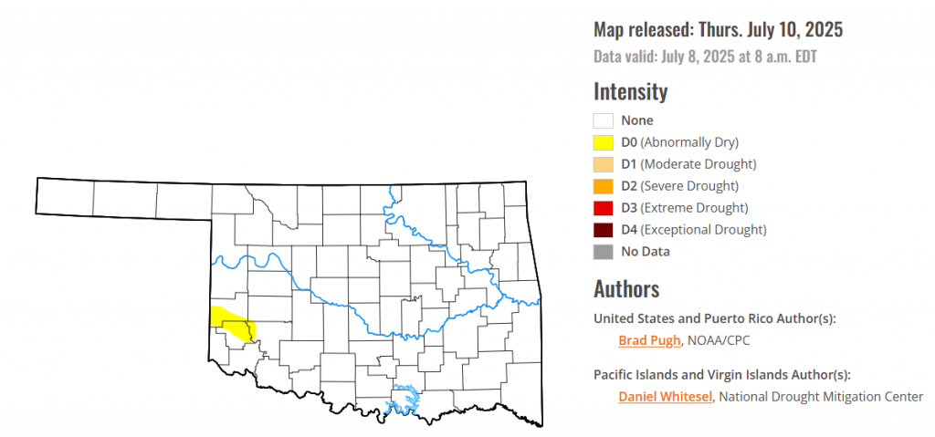
According to the latest Oklahoma drought monitor report, exceptional drought remains at zero percent, unchanged from the start of the calendar year.
Extreme drought or worse conditions remain at zero percent, unchanged since the week of October 29, 2024.
Severe drought or worse conditions remain at zero percent, unchanged since the week of May 29, 2025.
Moderate drought or worse conditions remain at zero percent, unchanged since last week.
Abnormally dry or worse conditions have emerged this week in parts of Greer county, Beckham county and Kiowa county
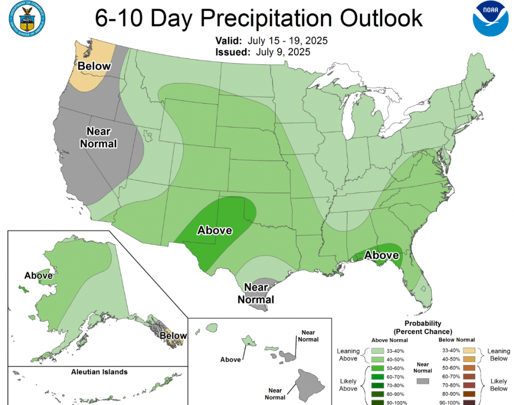
According to the 6-to-10-day precipitation outlook map, most of the state of Oklahoma is leaning above 40-50% chance of precipitation through July 19, while the westernmost part of the state is likely above 50-60% chance of precipitation through the same date.
To view the United States Drought Map, CLICK HERE.
Drought coverage and intensity continued its decline throughout the Great Plains since the spring with additional heavy rainfall during the first week of July. Despite the extremely heavy rainfall and flash flooding this past week, long-term drought dating back multiple years remains across south-central Texas. Improving drought conditions were made to parts of New Mexico, southwestern Colorado, and Arizona, while drought expanded and intensified across the Pacific Northwest and Northern Intermountain West. Much of the Corn Belt and Midwest remains drought-free, but a continued lack of adequate precipitation led to worsening drought for northern Illinois. Following another week of summertime thunderstorms with heavy rainfall, drought ended for most of the central to southwestern Florida Peninsula. Nearly all of the East, Ohio and Tennessee Valleys, and Lower Mississippi Valley are drought-free. 7-day temperatures (July 1-7), averaged 2 to 4 degrees F above normal across the Pacific Northwest, Northern Great Plains, Midwest, and New England. Cooler-than-normal temperatures were limited to the Southern Great Plains and portions of the Southwest. Parts of northwestern Alaska and the Yukon River Valley are designated with short-term drought, while drought of varying intensity continues for Hawaii. Although Puerto Rico currently remains drought-free, short-term precipitation deficits have increased.
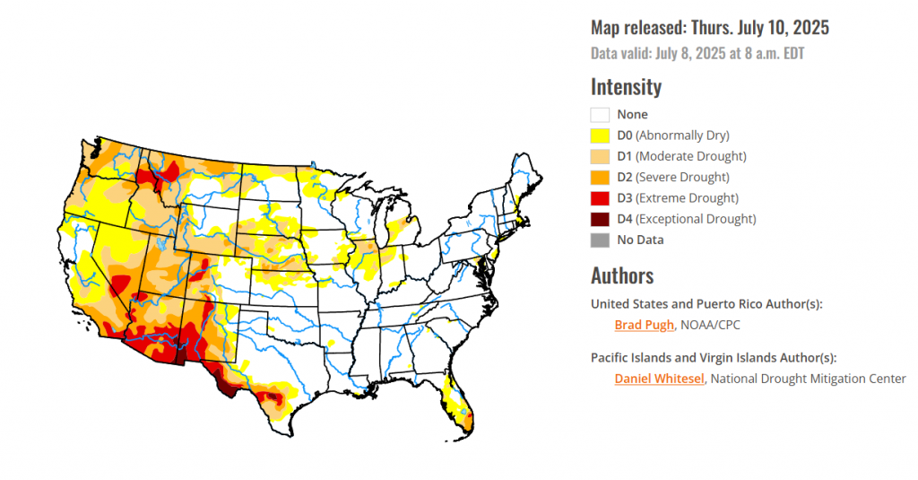
In Hawaii, no changes were made this past week with extreme drought (D3) designated for parts of the Big Island. Moderate to severe drought continues for Maui along with western Molokai. Most of Oahu and Kauai are drought-free.
In Alaska, Much above-normal temperatures during the first week of July contributed to the addition of moderate drought (D1) across northwestern Alaska and along the Yukon River Valley near the Canadian border. A slight reduction of abnormal dryness (D0) was made to better align with valley locations in eastern interior Alaska.
In Puerto Rico, Abnormal dryness (D0) continued to expand across Puerto Rico during the first week of July. Little to no precipitation was observed this past week across the southern and northeastern interior where D0 was added. During the past 60 days, precipitation has averaged below 50 percent throughout these areas as well. USGS monitored wells are showing an increase in depth for southern Puerto Rico, while soils are drying and crop stress is increasing.
In the South, A broad one to two-category improvement was made this past week to much of the ongoing long-term drought areas of Texas along with parts of New Mexico. The heaviest precipitation (5 to 10 inches, or more) occurred across the Edwards Plateau and south-central portions of Texas. According to CoCoRaHS gauge measurements from July 1-7, precipitation amounts ranged from 12 to 18 inches in eastern Burnet and western Williamson counties of Texas. Although 1 to 2-category improvements were made, a long-term drought dating back multiple years with low groundwater and reservoir levels continue. Therefore, an area of long-term drought (D1+) was maintained. The Edwards Aquifer Authority’s long-term observation wells at Medina and Uvalde counties remain in extreme (D3) to exceptional (D4) drought levels. Elsewhere, across the Southern Great Plains and Lower Mississippi Valley, no short-term or long-term drought is designated.
For the High Plains, Another round of heavy rainfall (1 to 2 inches, locally more) supported a 1-category improvement to parts of the Northern and Central Great Plains. April through early July is a wet time of year and 90-day precipitation, valid April 9-July 7, averaged more than 150 percent of normal for much of the Dakotas, Nebraska, eastern Colorado, and eastern Wyoming. Conversely, moderate drought (D1) across northeastern North Dakota was expanded westward due to another dry week and above-normal temperatures. The D1 is supported by the 30 to 60-day SPIs along with soil moisture indicators. Eastern Kansas has missed out on the heavy rainfall recently and abnormal dryness (D0) was added to that part of the state. Although precipitation was not that heavy across southwestern Colorado, enough precipitation along with support from SPIs at multiple time scales and the NDMC drought blends warranted small 1-category improvements.
In The West, Based on rapidly declining soil moisture and low 28-day average streamflows, additional degradations were warranted this week for the Pacific Northwest with an expanding coverage of moderate (D1) to severe (D2) drought across Oregon and Washington. Farther to the east, extreme drought (D3) was expanded to include more of northern Idaho. Parts of Utah also had a few areas with degradations based on 28-day streamflow, soil moisture, and high evaporative demand recently. A drier end to the wet season, 60 to 90-day SPI, and low soil moisture supported an expansion of abnormal dryness (D0) across northern to central California. Following recent beneficial precipitation along with timely wetness back to the late spring, improvements were warranted for parts of north-central and eastern Montana. Drought intensity remained nearly steady for the Desert Southwest although locally heavier Monsoon showers led to a small reduction in extreme drought (D3) for eastern and southern Arizona.
looking ahead Across the Midwest, Increasing 30 to 60-day precipitation deficits, worsening soil moisture and pasture conditions, and crop stress support a 1-category degradation for much of northern Illinois. Above-normal temperatures to start July has also led to higher evapotranspiration rates and water demand. Minor degradations were made to parts of Indiana, western Ohio, northwestern Kentucky, and northwestern Missouri where short-term precipitation deficits have increased. Heavier precipitation this past week led to a reduction in abnormal dryness (D0) in eastern Lower Michigan, but moderate drought (D1) was added to western parts of Lower Michigan. Recent heavy precipitation, exceeding 2 inches, led to a 1-category improvement for parts of western Iowa. Significant rainfall (1.5 to 2 inches) supported a 1-category improvement to parts of eastern Iowa, Wisconsin, and northern Minnesota.
To view the 6-10 Day Precipitation Outlook Map, click here.
To view the 6-10 Day Temperature Outlook Map, click here.
To view the Monthly Drought Outlook Map, click here.


