

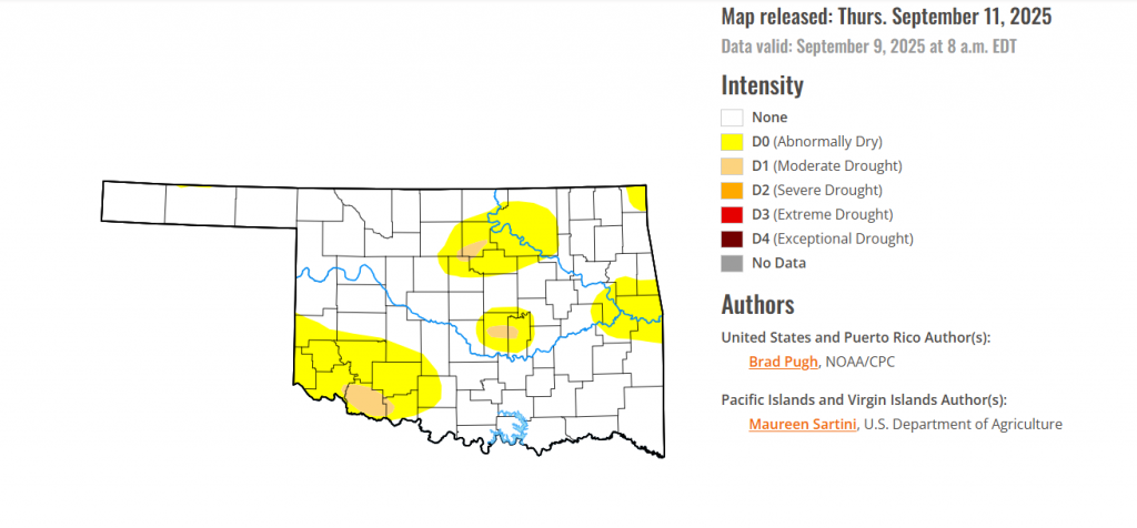
To view the latest Oklahoma drought map, CLICK HERE.
According to the latest Oklahoma Drought Monitor report, exceptional drought remains at 0 percent, unchanged from the start of the calendar year.
Extreme drought or worse conditions remain at zero percent, unchanged since the week of October 29, 2024.
Severe drought or worse conditions remain at zero percent, unchanged since the week of May 29, 2025.
Moderate Drought or worse conditions have emerged in Tillman County, covering a majority of the county.
Abnormally dry or worse conditions have considerably spread in southeastern Oklahoma.
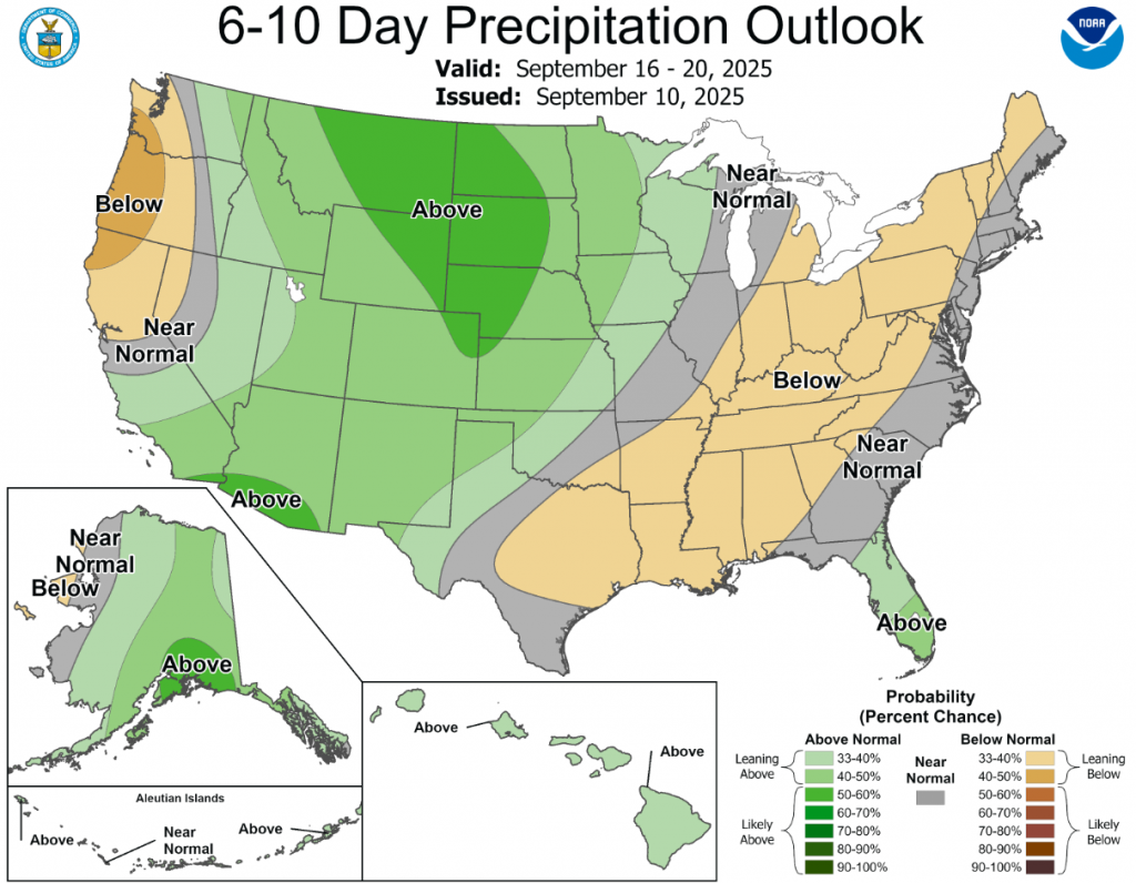
According to the 6-to-10-day precipitation outlook map, northwest Oklahoma is leaning above 40-50% chance of rain, western Oklahoma is leaning above 33-40% chance of rain, eastern Oklahoma is looking at near normal conditions, and southeastern Oklahoma is leaning below 33-40% chance of rain.
To view the United States Drought Map, CLICK HERE.
Abnormal dryness (D0) and short-term moderate (D1) to severe (D2) drought continued to expand across the Lower to Middle Mississippi Valley, Ohio Valley, Central Appalachians, Northeast, and Southeast. However, heavy precipitation (2 inches or more) resulted in a 1-category improvement to central and eastern portions of Kentucky and Tennessee. Enhanced moisture, associated with Hurricane Lorena in the East Pacific, led to locally heavy precipitation and drought improvements to parts of the Desert Southwest. Following a relatively wet week for this time of year, minor improvements were made to parts of Oregon. Elsewhere, little to no changes were warranted for the Pacific Northwest and California. A strong cold front for early September triggered heavy precipitation and drought improvements across New Mexico and the Rio Grande Valley of Texas. Much of the Central to Northern Great Plains and Upper Mississippi Valley remained drought-free. 7-day temperatures (September 2-8) averaged below-normal across most of the central and eastern U.S. with above-normal temperatures limited to the Pacific Northwest, Northern Intermountain West, Great Basin, and California. Widespread drought of varying intensity continued for Hawaii, while Alaska and Puerto Rico remained drought-free.
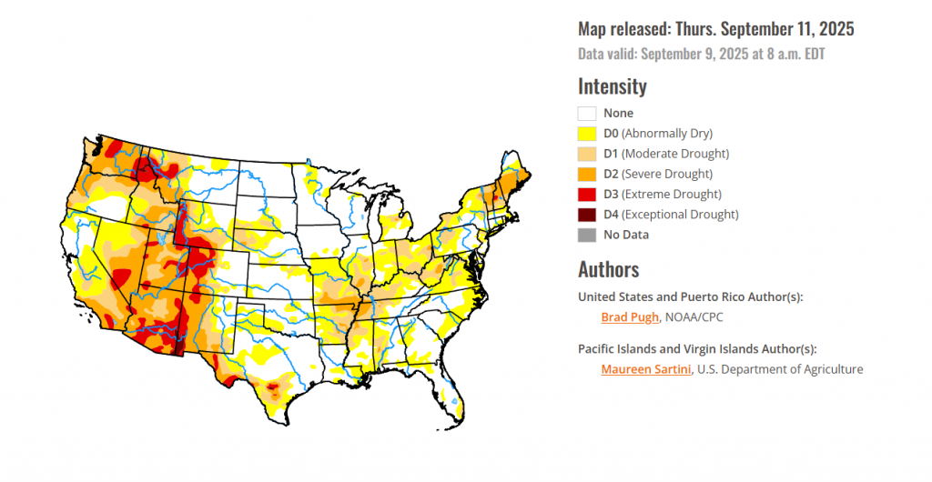
In the southern plains, Heavy precipitation (1.5 to 2 inches or more) supported a 1-category improvement to central and eastern Tennessee, while 30 to 60-day SPI along with soil moisture indicators resulted in the expansion of severe drought (D2) across western Tennessee, northern Mississippi, and northeastern Arkansas. Increasing 30 to 60-day precipitation deficits supported extending abnormal dryness (D0) south to the Mississippi Gulf Coast. For the long-term drought areas designated in Texas, a round of heavy precipitation (more than 1.5 inches) this past week resulted in 1-category improvements. Based on the 120-day SPI and NASA SPoRT soil moisture, D0 was expanded across southwestern Oklahoma with the addition of a small moderate drought (D1) area. 30 to 60-day SPIs along with declining soil moisture supported an increasing coverage of D0 across the Texas Panhandle and Edwards Plateau.
In the High Plains, Heavy precipitation (more than 2 inches) occurred in D-nada areas of central Kansas, but significant precipitation (1.5 to inches) led to a minor decrease in abnormal dryness (D0) in southwestern Kansas. Conversely, a slight increase in D0 and moderate drought (D1) was made to eastern Kansas. Significant precipitation (more than 0.5” and locally 2-3”) supported improvements across southern Colorado, while worsening SPIs led to a slight expansion of severe (D2) to extreme (D3) drought for northern Colorado. A majority of the Dakotas, Nebraska, and eastern Wyoming remain drought-free.
In the West, Heavy precipitation (1 to 2.5 inches) supported a decrease in severe (D2) to extreme (D3) drought around the Albuquerque, Santa Fe, and Las Cruces areas of New Mexico. In addition, NDMC’s long-term drought blend was used as guidance. Locally heavy precipitation led to improvements across portions of southeastern Nevada, southwestern Utah, and western to southern Arizona. Conversely, the continued drier-than-normal Monsoon (60-day precipitation averaged 50 percent below normal) supported an expansion of extreme drought (D3) for eastern Arizona. A favorable response to heavy precipitation (2 to 2.5 inches) two weeks ago led to the removal of extreme drought (D3) in southwestern Montana. Farther to the north, a 1-category degradation was made in northwestern Montana after a reassessment of longer term metrics including the NDMC blend. A small increase in extreme drought (D3) in eastern Washington was made to match up better with 6-month SPI. An unusually wet start to September resulted in small areas of improvement to Oregon. Elsewhere across the Pacific Northwest and California, no changes were needed.
Looking Ahead, The drier pattern is likely to persist across much of the eastern and central U.S. through September 15. Along with the continued dryness dating back to August, a transition to warmer-than-normal temperatures is underway throughout the central U.S. and summerlike heat is forecast to expand east across the Mississippi and Ohio Valleys. From September 13 to 15, maximum temperatures are expected to reach the upper 90s to near 100 degrees F from St Louis south to Memphis. Another week of heavy rainfall is forecast to affect the southern third of the Florida Peninsula and portions of New Mexico. Showers and thundershowers will shift eastward from Oregon and the Northern Intermountain West to the Northern Great Plains. The Climate Prediction Center’s 6-10 day outlook (valid September 16-20, 2025) favors above-normal temperatures for the nearly the entire lower 48 states, southeastern Alaska, and Hawaii. The largest above-normal temperature probabilities (70-80 percent) are forecast across the Mississippi Valley. The outlook leans towards the drier side across most of the Northeast, Mid-Atlantic, Ohio and Tennessee Valleys, and Lower Mississippi Valley. Above-normal precipitation is more likely for the Upper Mississippi Valley, Northern to Central Great Plains, Rockies, and Southwest. The outlook also favors above-normal precipitation for most of Alaska and Hawaii.
To view the 6-10 Day Precipitation Outlook Map, click here.
To view the 6-10 Day Temperature Outlook Map, click here.
To view the Monthly Drought Outlook Map, click here.


