

To view the latest Oklahoma drought map, CLICK HERE.
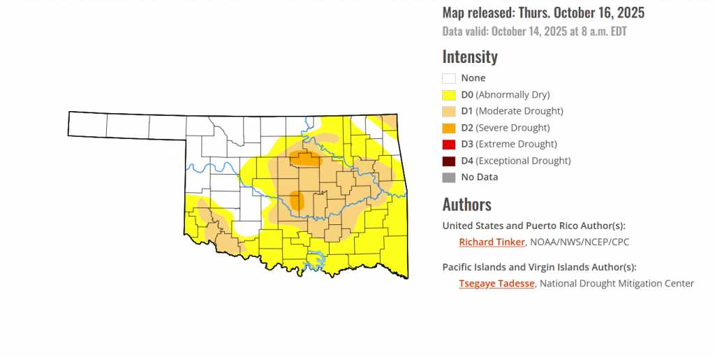
According to the latest Oklahoma Drought Monitor report, exceptional drought remains at 0 percent, unchanged from the start of the calendar year.
Severe Drought: As of October 16, 2025, severe drought (D2) has emerged in Payne, Noble, Pawnee, Cleveland, Oklahoma, and Pottawatomie counties, covering 1.97% of the state.
Widespread Dryness: Over 65 percent of the state is now experiencing abnormally dry to severe drought conditions ( D0-D2)
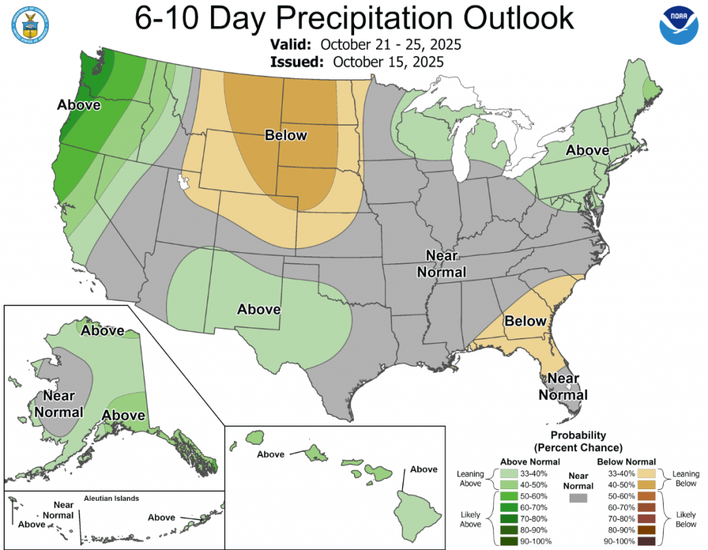
According to the 6-to-10-day precipitation outlook map, a large majority of Oklahoma is looking at near-normal conditions through October 25, 2025. With far southwestern Oklahoma leaning above 33-40% chance of rain through the same date.
To view the United States Drought Map, CLICK HERE.
A late-season surge of tropical moisture brought heavy precipitation and areas of flooding to parts of the Four Corners States. Amounts of 4 to locally over 6 inches were reported in parts of interior Arizona and southern Colorado. Farther east, a potent coastal storm system brought gusty winds and heavy rains to parts of the East Coast. Rainfall totals approached one foot near Georgetown and Pawley’s Island, SC while amounts of 7 to 10 inches were scattered across South Carolina and near Whiteville, NC. Totals of 4 to 6 inches were measured at scattered locations from South Florida northward through eastern Massachusetts. Wind gusts reached 60 to 65 mph at several buoys near the North Carolina Coast; Cape Lookout, NC; and Island Beach Park, NJ. In contrast, only a few tenths of an inch, at most, fell across southeast California, most of the Great Basin, the central and northern High Plains, much of the Great Plains, the Great Lakes Region, portions of the Middle and Lower Mississippi Valley, much of the interior Deep South, and the Gulf Coast Region. Drought designations improved by multiple categories in some of the wetter areas across interior Arizona, southern Colorado, and eastern South Carolina while broad areas of 1-category improvement covered the central and southwestern Four Corners Region, The Middle and Lower Ohio Valley and adjacent locations, and portions of the Atlantic Coast from south Florida through southern New England. In contrast, dryness and drought persisted or intensified across large parts of the Deep South away from the Atlantic Coast, the central Gulf Coast Region, the Lower Mississippi Valley, the east-central and south-central Great Plains, and scattered locations across the northern tier of the Lower-48 from Montana through northern New England.
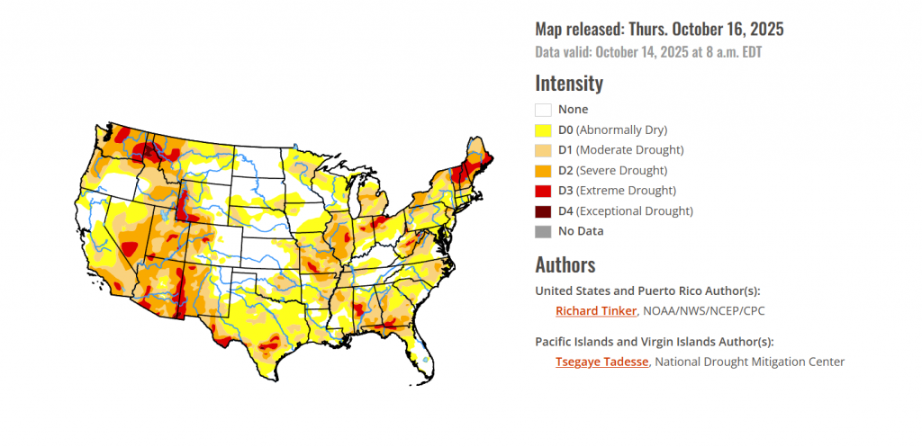
In the southern plains, Recent rainfall allowed for some improvement in dryness and drought across western Tennessee, adjacent Mississippi, central Oklahoma, and western Texas. However, deterioration was more common in aggregate across the South Region, with most of northwestern Mississippi, Louisiana, and eastern Oklahoma noting some intensification. There were scattered areas of moderate to locally heavy rainfall, but most of the Region recorded subnormal amounts for the week.
In the High Plains, Heavy to excessive precipitation pounded the higher elevations of Colorado. Most areas from west-central through south-central portions of the state received at least 3 inches of precipitation, with much heavier amounts – approaching 8 inches in spots – falling on the higher elevations of south-central Colorado. This precipitation let to widespread improvements, with some of the wetter areas noting 2-category improvements. Elsewhere light to moderate precipitation (generally 0.5 to 1.5 inches) fell on most of the Plains and Wyoming, with amounts over an inch recorded in isolated sections of central Kansas, eastern North Dakota, and westernmost Wyoming. Significant areas of dryness development or deterioration were limited to eastern Kansas and the southern tier of South Dakota.
In the Midwest, Heavy rain brought widespread improvement to most of Kentucky, the southern reaches of Ohio and Indiana, eastern Ohio, and a few areas near southern Lake Michigan. A few patches in central Ohio assessed a 2-category improvement. Lesser amounts fell elsewhere, leading to scattered areas of deterioration across Illinois, central Indiana, Michigan, east-central and northwestern Wisconsin, Minnesota, northwestern Iowa, and parts of Missouri (especially the western tier). For the past 2 months, precipitation totals 4 to 8 inches below normal are fairly widespread across most of Missouri and Illinois, plus parts of southwestern Iowa and the east-central Michigan Lower Peninsula. Much of northern Indiana and northwestern Ohio are 3 to locally 5 inches below normal during this period.
To view the 6-10 Day Precipitation Outlook Map, click here.
To view the 6-10 Day Temperature Outlook Map, click here.
To view the Monthly Drought Outlook Map, click here.


