

To view the latest Oklahoma drought map, CLICK HERE.
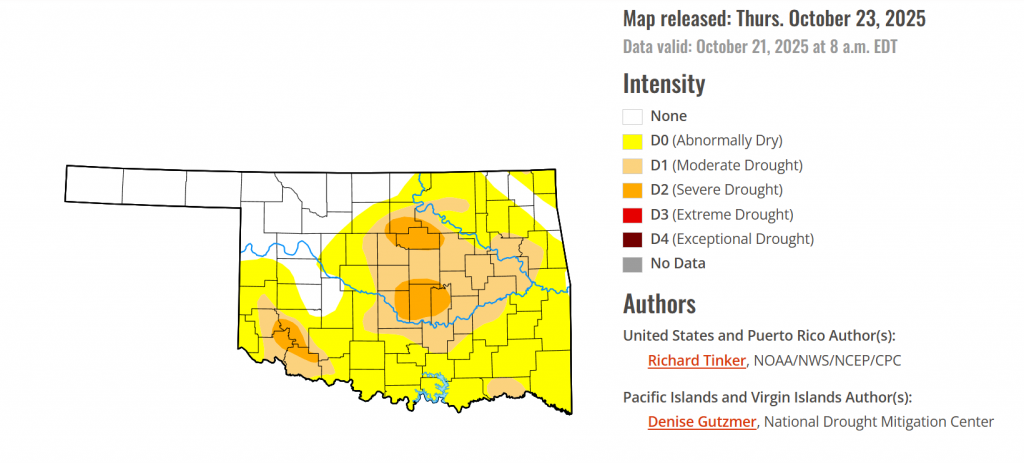
According to the latest Oklahoma Drought Monitor report, exceptional drought remains at 0 percent, unchanged from the start of the calendar year.
Severe Drought: Severe drought (D2) has now spread in southwestern Oklahoma, affecting Gerrer, Jackson, Tillman, and Kiowa counties, covering 5.73 percent of the state.
Widespread Dryness: Over 72 percent of the state is now experiencing abnormally dry to drought conditions.
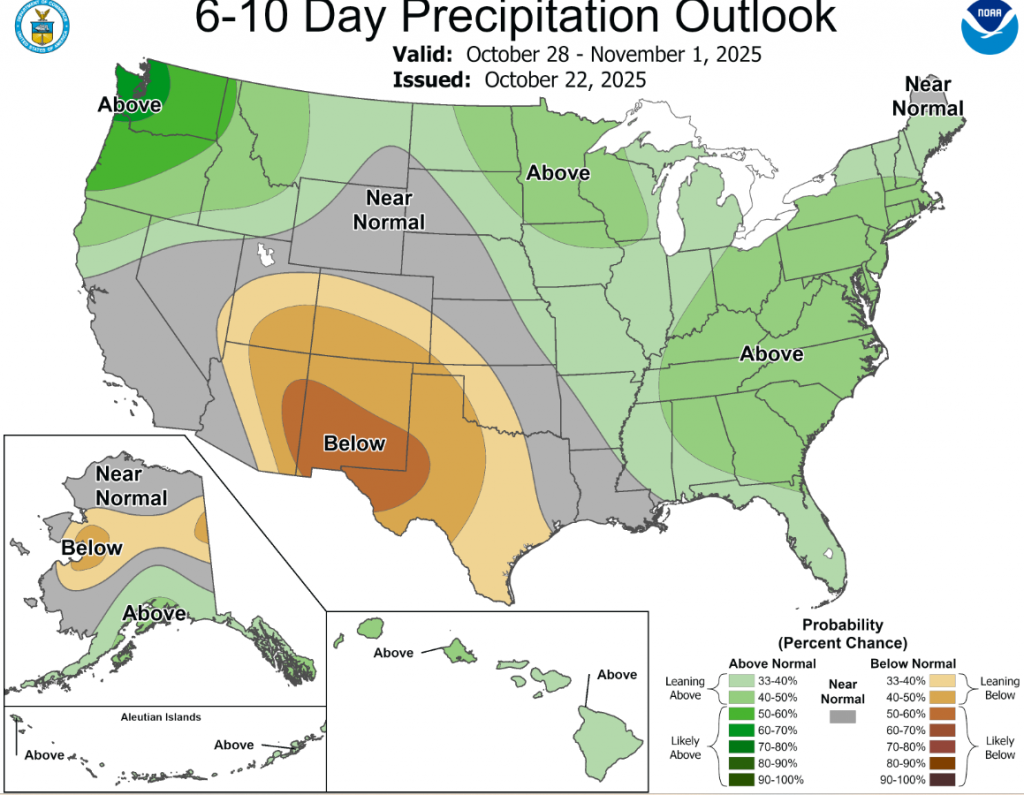
According to the 6-to-10-day precipitation outlook map, Eastern Oklahoma will experience near normal conditions, while Western Oklahoma is leaning below 33-40% chance of rain. The panhandle and far southwestern Oklahoma are leaning below 40-50% chance of rain.
To view the United States Drought Map, CLICK HERE.
Recently, precipitation has been spatially variable across the Contiguous U.S. (“Lower-48”). Over the past 30 days, heavy precipitation (4 to locally over 8 inches) fell on parts of central and southern New England, the interior Northeast (especially eastern New York state), the Ohio Valley (particularly northern Kentucky and adjacent areas), eastern South Carolina, eastern Florida, parts of the Tennessee and adjacent Mississippi Valleys, isolated sites in the central Plains, the higher elevations in the Rockies, central Arizona and other scattered locations across the Southwest, parts of the Great Basin, portions of California (where such amounts are unusual this early in the wet season), and the Pacific Northwest (where these amounts are not unusual). In stark contrast, an inch or less of precipitation has been noted in the desert Southwest and lower elevations across the interior West, most of the central and southern Plains, the northern Great Plains, the northwestern Great Lakes, portions or northern and western Florida, and some interior sections of the Southeast and Mid-Atlantic region. Given the regional variability, there were a lot of changes in the Drought Monitor this week, with large parts of the West, much of the Ohio and middle Mississippi Valleys, and scattered locations across northern Mississippi, the Eastern Great Lakes, and the Northeast. At the same time, conditions have deteriorated across much of the southern and south-central Plains, the South Atlantic region from interior Georgia through eastern Virginia, southern parts of the Lower Mississippi Valley, and scattered areas across the rest of the Southeast, the Mid-Atlantic region, the Northeast, the Upper Mississippi Valley, and the northern Plains. In sum, the array of improvements and deterioration incorporated into this week’s Drought Monitor resulted in slight declines in overall coverage of the various drought severity levels across the Lower-48. Abnormally dry or worse conditions cover 72 percent of the country, down from 74 percent last week. About 21 percent of the country is experiencing Severe Drought or worse (D2-D4), down slightly from 23 percent last week. For the 50 states plus Puerto Rico in total, coverage of abnormally dry or worse conditions fell from 62 to just under 60.5 percent.
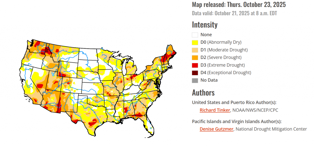
In the southern plains, Moderate to heavy rain resulted in several areas of improvement in Tennessee, central and northern Mississippi, northeastern Louisiana, and eastern Oklahoma. Farther south and west, subnormal precipitation continued for another week, resulting in numerous areas of deterioration from central and southern Louisiana westward across Texas and central through western Oklahoma. The proportion of the Region experiencing some degree of dryness or drought (D0+) increased slightly this week, from 79 percent to about 80.5 percent. There was a bigger jump in areas covered by some degree of drought (37 percent, up from a bit over 32 percent). The most intense drought (D3 with some isolated patches of D4) cover parts of the panhandle of western Texas and a sizeable part of south-central Texas. The heaviest rains this week (2 to 4 inches) were observed in a broken pattern from northwestern Louisiana through northern Mississippi. In contrast, southern sections of the Lower Mississippi Valley and the vast majority of Texas and Oklahoma received a few tenths of an inch at best, with most sites reporting no measurable precipitation.
In the High Plains, A wide range of precipitation totals were observed last week. Generally, 1.5 to 3.0 inches hit the northern and western Dakotas, much of central and eastern Wyoming, and scattered locations in northwestern Wyoming. An inch or a little more fell on many locations in a swath from central Nebraska into southeastern South Dakota, but other locations reported several tenths of an inch of precipitation at best, with most areas from southwestern Wyoming through western Nebraska and from eastern Nebraska through Kansas reporting little or none. This pattern resulted in less change here than in most other regions. Areas of deterioration were introduced in parts of the east-central and southeastern High Plains Region while improvement resulted from heavier precipitation farther west. The most widespread areas of improvement covered southwestern Colorado and western Wyoming. Coverage of dryness and drought is considerably lower in this region than in others, with the total area entrenched in some degree of dryness or drought (D0-D4) dropping slightly to a bit over 36 percent this week. The extent of Extreme Drought (D3) was almost cut in half, from 3.3 percent down to 1.7 percent. There is no D4 in the Region, but D3 remains across much of southwestern Wyoming and part of central Colorado. The proportion of the Great Plains States in this Region experiencing some degree of dryness or drought (D0-D4) is relatively low compared to much of the Lower-48; specifically, 3 percent of North Dakota, 32 percent of South Dakota, 35 percent of Nebraska, and 28 percent of Kansas.
In the Midwest, Once again this week, many parts of the Midwest Region received moderate to heavy precipitation. There was some expansion of dryness and moderate drought from northern Minnesota through Iowa, where less precipitation fell, but much broader areas of improvement were noted over the Michigan Lower Peninsula and the Ohio Valley States. Overall, the extent of any degree of dryness or drought (D0-D4) dropped only slightly by 1 percent (to 71 percent), but there was a more substantial decrease in the coverage of the most intense categories. Severe drought or worse (D2-D4) covered over 14.5 percent of the Region on October 14, but less than 10 percent this week. The worst conditions in the Region (D3) stretched across parts of southwestern Missouri, east-central Illinois, central and northeastern Indiana, and northwestern Ohio. Between 2 and 4 inches of precipitation fell on a band from east-central Missouri across upper southern Illinois and into west-central Indiana, while 1.5 to 3.0 soaked a large part of the Michigan Lower Peninsula.
To view the 6-10 Day Precipitation Outlook Map, click here.
To view the 6-10 Day Temperature Outlook Map, click here.
To view the Monthly Drought Outlook Map, click here.


