

To view the latest Oklahoma drought map, CLICK HERE.
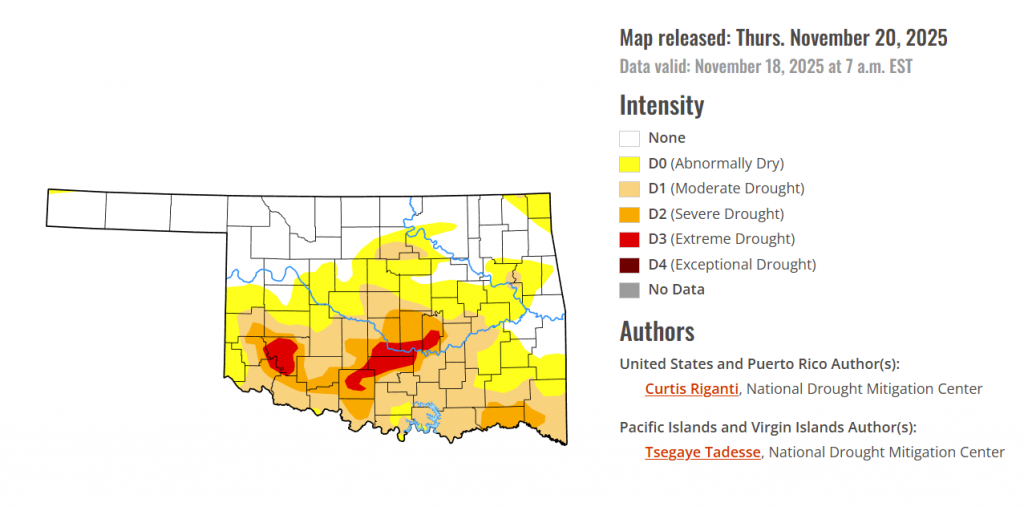
According to the latest Oklahoma Drought Monitor report, exceptional drought remains at 0 percent, unchanged from the start of the calendar year.
Extreme Drought (D3) has grown significantly in the south this week, covering 3.48% of the state. New extreme drought has been reported in Stephens, Garvin, McClain, Cleveland, Pottawatomie, and Seminole counties.
Overall dryness covers 61% of the state, including D0 to D3 drought.
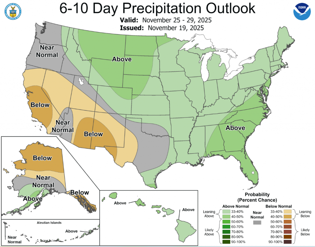
According to the 6-to-10-day precipitation outlook map, southern Oklahoma is expected to see near-normal conditions through November 29, and northern Oklahoma is leaning above a 33-40% chance of rain through that same date.
Dry weather covered most of the central and eastern U.S. this week, with a few localized areas of heavier precipitation falling in the Northeast and parts of eastern South Dakota. In the West, heavy rain and snow was widespread, especially in parts of southern Nevada, southern and coastal California, the Sierra Nevada, the Pacific Northwest and northwest Montana. Temperatures west of the Mississippi River were mostly warmer than normal, especially in Montana and Wyoming, where temperatures of 12 or more degrees above normal were common. East of the Mississippi River, near- or below-normal temperatures were widespread, especially in southern Georgia and Florida, where temperatures were 6-12 degrees colder than normal. Given the wetter weather recently, improvements continued in parts of the Northeast, where streamflow and soil moisture continued to recover and precipitation deficits lessened. Improvements were also widespread in California and Washington, where recent precipitation has cut into or erased precipitation deficits and boosted soil moisture and streamflow. Degradations were common in Oklahoma, Texas, Louisiana, Florida, Georgia and North Carolina, where short-term precipitation deficits grew. Widespread degradation also occurred in parts of Nebraska, central and northeast Montana and the western Great Lakes area, as primarily short-term dryness intensified in each of these areas. Recent pockets of drier- or wetter-than-normal weather led to a few small changes in areas of abnormal dryness in Puerto Rico. Wetter weather in the windward sides of Hawaii led to local improvements on Oahu, Maui and the Big Island, where streamflows have responded well to increased precipitation.
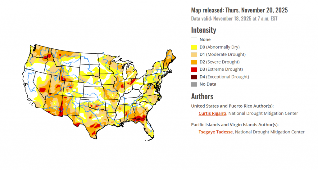
In the southern plains, Dry weather occurred across nearly the entire South region this week, which led to widespread degradations in conditions in some states. Warmer-than-normal temperatures occurred in parts of Texas and Oklahoma and some locales in Arkansas, while near- or below-normal temperatures were more common elsewhere. In the Texas Panhandle and southwest parts of the Lone Star State, temperatures of at least 9 degrees above normal were common. South of Oklahoma City, extreme drought developed where ponds dried up amid large short-term precipitation deficits and above-normal evaporative demand. Degradations occurred across large parts of southern Oklahoma where short-term precipitation deficits continued amid above-normal temperatures. A mix of short- and long-term precipitation deficits and warm temperatures led to degradations in southern Texas, while conditions also degraded in parts of north Texas and the Texas Panhandle during recent dry and warm weather. Short-term precipitation deficits also grew in much of northeast Texas, Louisiana, southwest Arkansas and southern Mississippi, leading to degrading conditions. Streamflow and soil moisture levels also were low in some areas that worsened this week.
In the High Plains, Primarily dry and warmer-than-normal weather occurred in the High Plains region this week, with the exceptions of east-central South Dakota and some high-elevation areas of Colorado and Wyoming. Temperatures in Wyoming and parts of eastern Colorado were 12 or more degrees above normal this week, while eastern parts of the Dakotas, Nebraska and Kansas were mostly 3-9 degrees warmer than normal. Short-term precipitation deficits and decreasing soil moisture in some areas led to expansions and development of abnormal dryness and moderate drought in parts of eastern and central Nebraska. In western Nebraska, abnormal dryness and moderate drought expanded under similar conditions, while severe drought also developed where more substantial longer-term precipitation deficits were taking place. In and near the Kansas City area, moderate and severe drought locally expanded where soil moisture levels decreased and short-term precipitation shortfalls grew. Abnormal dryness expanded across the southeast Colorado plains where short-term precipitation deficits grew, while moderate drought filled in in northwest Colorado where short-term dryness aligned with long-term precipitation deficits.
In the Midwest, This week, scattered precipitation fell in parts of central and eastern Missouri, Illinois, southern Indiana, northern and eastern Iowa and the eastern Upper Peninsula of Michigan. Otherwise, primarily dry weather occurred. In Decatur, Illinois, stage one water restrictions began, and severe and extreme drought expanded in the area surrounding Champaign-Urbana as shortages in soil moisture and precipitation intensified again. From northeast Iowa into the western Great Lakes area, moderate and severe drought and abnormal dryness developed or expanded. Short-term precipitation deficits and soil moisture deficits were especially intense in the Wisconsin Northwoods, where severe drought developed and moderate drought expanded. Streamflow and soil moisture continued to struggle amid growing precipitation deficits in parts of Missouri, where abnormal dryness and moderate and severe drought locally expanded. Severe drought now covers the entire Kansas City area, where soil moisture levels continue to be low amid a very dry late summer and autumn. Warmer-than-normal temperatures occurred in the western reaches of the Midwest (primarily along and west of the Mississippi River), while near- or below-normal temperatures were more common in Indiana, Kentucky, Ohio and the Lower Peninsula of Michigan.
To view the 6-10 Day Precipitation Outlook Map, click here.
To view the 6-10 Day Temperature Outlook Map, click here.
To view the Monthly Drought Outlook Map, click here.


