

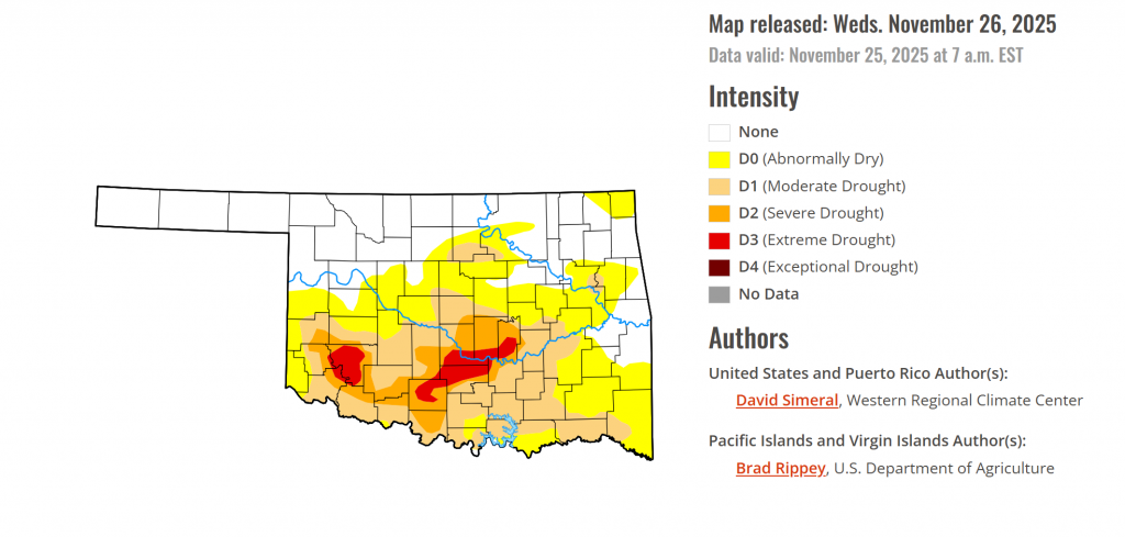
The latest U.S. Drought Monitor report, released this week, delivers a mixed signal to Oklahoma’s agriculture sector. While rainfall and management efforts have helped reduce the overall extent of severe and moderate dryness, an entrenched area of Extreme Drought (D3) remains a major threat to winter wheat, forage, and water supplies in the southern and central parts of the state.
D0-D4 drought conditions in the current period indicate that nearly two-thirds of Oklahoma (61.37%) is experiencing conditions ranging from Abnormally Dry (D0) to Exceptional Drought (D4).
The total area facing Moderate to Exceptional Drought (D1-D4) decreased by 3.39%, now covering 33.31% of the state. The area under Severe to Exceptional Drought (D2-D4) also declined, dropping 1.57% to 11.11%.
The percentage of Oklahoma under Extreme to Exceptional Drought (D3-D4) held static at 3.48%. This stability means conditions in the hardest-hit areas are not improving, putting critical cattle and water resources under sustained stress.
Extreme Threat Zeroes in on South-Central Counties
The 3.48% Extreme Drought (D3) coverage is concentrated in areas vital to Oklahoma’s agricultural production, particularly impacting ranchers and row-crop farmers. Counties now designated with new or persistent Extreme Drought include: Stephens, Kiowa, Garvin, McClain, Cleveland, Pottawatomie, and Seminole
To view the latest Oklahoma drought map, CLICK HERE.
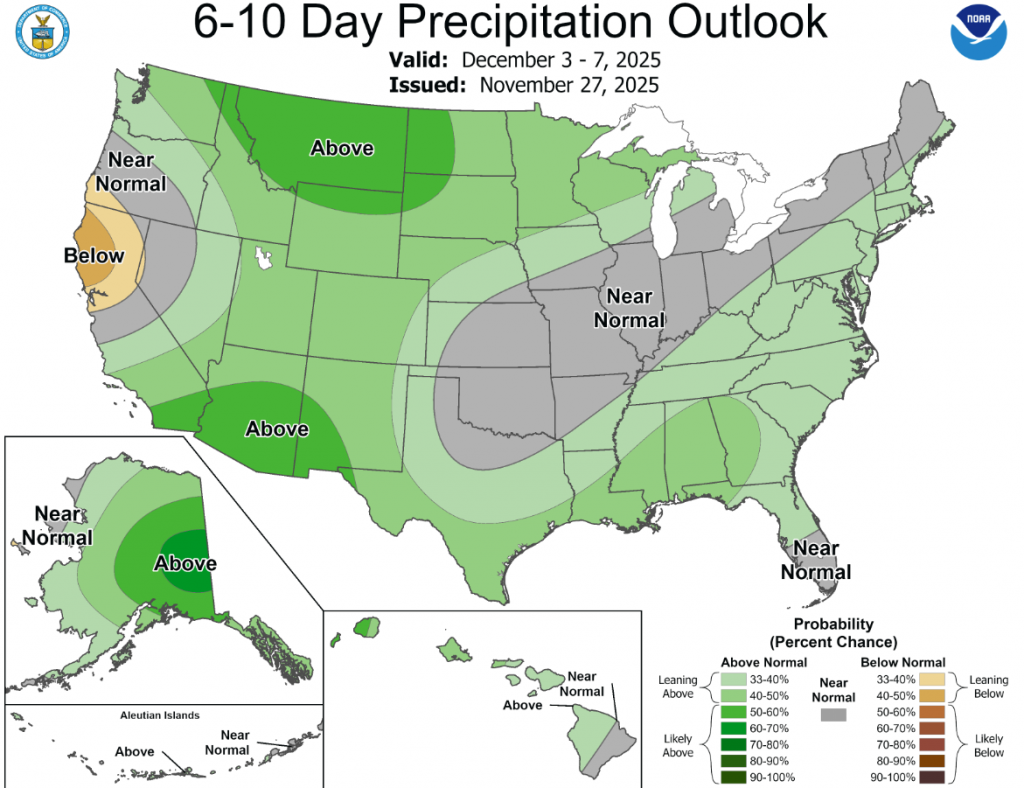
According to the 6-10 day precipitation outlook map, precipitation is leaning towards Near Normal across most of Oklahoma. The forecast indicates the Oklahoma Panhandle has a slightly above-average chance of rain through that date.
In the Southern Plains: Across much of the region, generally dry conditions prevailed this week, especially in the far southern and western portions of the region, with little or no precipitation observed. In contrast, light to moderate rainfall (2 to 4+ inches) was observed along a swath extending from central Texas to southwestern Arkansas. The beneficial rainfall led to one-category improvements in areas of Moderate (D1) to Extreme Drought (D3) with most of the improvements focused on areas of central and northeastern Texas. Elsewhere, minor improvements were made on the map in southeastern Oklahoma, southwestern Arkansas, and northern Mississippi. In Louisiana, short-term precipitation deficits (past 90-day period) and declining soil moisture levels led to expansion of areas of Moderate Drought (D1) and Severe Drought (D2). For the week, average temperatures were well above normal across the region with anomalies ranging from 4 to 16 degrees F above normal. Looking at reservoir conditions in Texas, Water for Texas (November 25) was reporting statewide reservoirs at 74% full, with many reservoirs in the eastern part of the state in very good condition, while numerous reservoirs in the western portion of the state were experiencing continued below-normal levels.
In the High Plains: On this week’s map, only minor changes were made in the region, including changes in eastern Kansas, Nebraska, and southwestern South Dakota. For the week, precipitation across the region was generally light and primarily restricted to eastern and central portions of Kansas as well as in eastern and central South Dakota. In terms of average temperatures, warmer-than-normal temperatures (5 to 15+ degrees F above normal) were observed across the region with the greatest anomalies observed in the Dakotas. According to NWS NOHRSC, the current regional snowpack spatial extent is limited to areas of central and northern North Dakota.
In the West: On this week’s map, improvements were made in the southern extent of the region in Missouri in response to widespread rainfall (1 to 2.5 inches) across the state. Elsewhere in the region, some minor improvements were made in southern Illinois, central Indiana, and northwestern Michigan. For the week, average temperatures were above normal across the western and southern extent of the region, with anomalies ranging from 5 to 15 degrees F above normal and the greatest departures observed in western Minnesota and southern Missouri. Temperatures were cooler in the eastern half of the region ranging from 5 degrees F above normal to 5 degrees below normal (central and northern Michigan, eastern Ohio). Using the Southeast Regional Climate Center’s Climate Perspectives tool, the past two months have been very dry across much of the region, with record to near-record dryness observed in the following locations: Duluth, Minnesota (-4.52 inch departure); Madison, Wisconsin (-3.57 inches); Green Bay, Wisconsin (-2.58 inches); Detroit, Michigan (-3.75 inches); and St. Louis, Missouri (-4.3 inches).
To view the 6-10 Day Precipitation Outlook Map, click here.
To view the 6-10 Day Temperature Outlook Map, click here.
To view the Monthly Drought Outlook Map, click here.


