

To view the latest Oklahoma drought map, CLICK HERE.
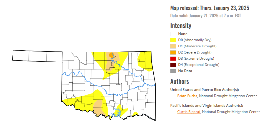
According to the latest Oklahoma drought monitor report, exceptional drought remains at zero percent, unchanged from the start of the calendar year.
Extreme drought or worse conditions remain at zero percent, unchanged since the week of October 29, 2024.
Severe drought or worse conditions are unchanged at 0.33 percent, since January 2.
Moderate drought or worse conditions are unchanged from 5.24 percent last week.
Abnormally dry or worse conditions have decreased slightly to 24.11 percent, down from 24.88 percent last week.
According to the 6-to-10-day precipitation outlook map, most of the state of Oklahoma is leaning above a 40-50% chance of precipitation through February 1, 2025. The northern corridor of the state, including the panhandle, is leaning above a 33-40% chance of precipitation, and a few small pockets on the southeastern border of the state are leaning above a 50-50% chance of precipitation through that February 1 date.
To view the United States Drought Map, CLICK HERE.
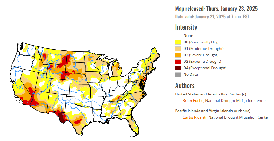
Almost all the U.S. experienced a cooler-than-normal week, with only a handful of areas being above normal. The coolest readings were in the Rocky Mountains, where departures were up to 15 degrees below normal, while the warmest areas were in central and northern California, New England, and south Florida, where departures were a few degrees above normal. Precipitation was also greatest in the Rocky Mountains where the upper elevations recorded a good week of snow. Precipitation was widely scattered throughout the Southeast where some portions of north Florida had over 200% of normal precipitation for the week. At the end of the period, a cold air mass settled in over the eastern two-thirds of the country, bringing cold air all the way down into the deep South with winter storms along the Gulf Coast. There are multiple regions that have had several weeks of dryness with minimal precipitation. Even though it is winter, and drought tends to move slower due to reduction of demand, these areas will continue to be monitored for degradation if the pattern continues and the data support it.
In the Southern Plains, temperatures were cooler than normal this week with most areas 5-10 degrees below normal. It was mostly a dry week throughout the region with only areas of southern Texas recording above-normal precipitation. Some areas are pushing 60 or more days without any significant precipitation in portions of Oklahoma and Texas, but as it is climatologically the driest time of the year for some of these areas, drought degradation has been slow. Changes this week included an expansion of abnormally dry conditions over extreme northwest Arkansas and central Texas. Moderate drought also expanded over portions of central Texas due to reports of crop losses due to lack of soil moisture in the region. Extreme drought expanded along the Big Bend of Texas where hydrological indicators are supporting the expansion. Some improvements to the severe and extreme drought were made in middle Tennessee, but abnormally dry conditions were expanded in the southwest portion of the state.
In The High Plains, some of the coldest air of the year settled into the region over the last week. Departures from normal temperatures were 12-15 degrees below normal in portions of Wyoming, South Dakota, and Colorado, and into Kansas and Nebraska. Dry conditions dominated the region with only portions of southwest Kansas and the Plains of Wyoming and Colorado recording precipitation. December and January are the driest months of the year and deficits are accumulating with little to no precipitation over the last several weeks. Conditions will continue to be monitored for further degradation in the region.
In the West, It was a dry week for most of the region outside of the accumulated snow in the Rocky Mountains and into northern New Mexico. Temperatures were mainly cooler than normal over the region, with portions of the Rocky Mountains 12-15 degrees below normal for the week. Portions of northern and central California were near normal to slightly above normal for temperatures this week. The abysmal start to the water year continues over much of southern California, southern Nevada and Utah, and into Arizona and New Mexico. Most of the managed water systems are fine in the region after two consecutive wet winters, but the short-term drought indicators for the current water year are highlighting the significant short-term drought in the Southwest into southern California. Degradation to drought status continued this week with drought expanding and intensifying over much of southern California. Abnormally dry conditions expanded over much of western New Mexico and northeastern Arizona, with extreme drought expanding over western Arizona and severe drought expanding over southwest Utah. The recent wet pattern was enough to remove the remaining abnormally dry conditions out of central Oregon while the recent snows in the Rocky Mountains allowed for some drought intensity reductions in northern Colorado and with western and north central Wyoming. Colorado had moderate drought expand in the south, with a new pocket of abnormally dry conditions added in the Southwest.
Looking ahead, over the next five to seven days, it is anticipated that the greatest precipitation will be over the South into the Southeast from east Texas into western Alabama. Much of the country will see little to no precipitation with the most active precipitation areas from California into Wyoming and Montana, but amounts will generally be less than 1 inch for most locations. Temperatures are anticipated to be warmest over the central Plains to the upper Midwest with departures of 5-10 degrees above normal. The coolest temperatures will be in the west with most areas 5-10 degrees below normal.
The 6-10 day outlooks show that the probability of below-normal temperatures is greatest over the Southwest and in New England, while the greatest chances of above normal temperatures are over the High Plains and upper Midwest. Above-normal chances of above-normal precipitation are greatest over the southern United States from New Mexico into the Mid-Atlantic. The best chances of below normal precipitation are over the West and High Plains into the Midwest.
To view the 6-10 Day Precipitation Outlook Map, click here.
To view the 6-10 Day Temperature Outlook Map, click here.
To view the Monthly Drought Outlook Map, click here.


