

To view the latest Oklahoma drought map, CLICK HERE.
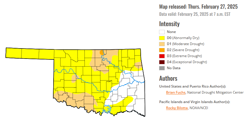
According to the latest Oklahoma drought monitor report, exceptional drought remains at zero percent, unchanged from the start of the calendar year.
Extreme drought or worse conditions remain at zero percent, unchanged since the week of October 29, 2024.
Severe drought or worse conditions are unchanged at 0.33 percent, since January 2.
Moderate drought or worse conditions have increased to 18.43 percent, up from 7.75 percent last week.
Abnormally dry or worse conditions have increased to 80.89, up from 65.73 percent last week.
According to the 6-to-10-day precipitation outlook map, the vast majority of the state is leaning above a 33 – 40% chance of precipitation through March 8, except for the western half of the panhandle which is leaning above a 40-50% chance of precipitation, as is a small pocket in the far Northeastern corner of the state. A small sliver along the Red River in the far Southwestern portion of the state is near normal chances of precipitation through that March 8 date.
To view the United States Drought Map, CLICK HERE.
With limited precipitation during the week, most of the country was dry after a fairly active week prior. The week was highlighted by the wild temperature swings from the first part of the period to the end. The current period started off with temperatures that were well below normal over much of the country and ended with temperatures that were well above normal. Valentine, Nebraska, had an observed low temperature of -33°F on Feb. 20, and this rebounded to 69°F on Feb. 25, a swing of 102 degrees over that five-day span. Precipitation was greatest over the coastal areas of the Pacific Northwest as well as along the Gulf Coast and Florida. In southern Louisiana, 4-6 inches of rain was common for the region. Even with cold temperatures over much of the eastern half of the country, the West was normal to slightly above normal for the week.
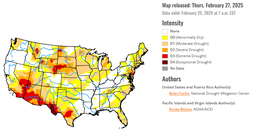
In the Southern Plains, it was a colder-than-normal week with temperatures in the 10-20 degrees below normal range over the entire area. The greatest rain occurred across the coastal areas of east Texas, Louisiana and portions of northeast Oklahoma. The region has been dry over much of the winter after a few very wet weeks in the autumn. The short-term data are picking up the dryness that also was prevalent prior to the wet November. As the dryness persists, moderate drought was expanded into more of southwest Oklahoma and into northern and central Texas. Abnormally dry conditions were expanded over much of southern Oklahoma and north Texas. Due to ongoing hydrological drought issues in south Texas, drought expanded this week with more moderate, severe and extreme drought conditions. Abnormally dry conditions were improved over east Texas but were not removed completely due to some lingering dryness being observed at longer timescales. The recent rains allowed for the removal of the abnormally dry conditions over southern Louisiana and some improvements in southern Mississippi, where both moderate drought and abnormally dry conditions were improved.
In the High Plains, light precipitation was measured from eastern Wyoming into Kansas and Nebraska as well as in portions of western North Dakota and the plains of eastern Montana. Most other areas were dry for the week. Colder-than-normal temperatures dominated the region with areas of southeast Kansas 20-25 degrees below normal for the week. With the dry conditions, moderate drought levels were expanded over southern Kansas along with additional abnormally dry conditions being shown.
The West was a very divided region with wetter-than-normal conditions in the north and zero precipitation in the south. The most abundant precipitation was along the coastal areas of Washington and Oregon and into Idaho and western Montana. Unlike the rest of the country, much of the West had near- to slightly-above-normal temperatures this week. The wetter pattern in Oregon allowed for abnormally dry conditions to improve in the west and both moderate drought and abnormally dry conditions improved in the northeast. No changes in Washington occurred this week as the most recent rains helped to stabilize conditions that had been deteriorating. In Idaho, abnormally dry conditions were improved over much of western and southern portions of the state. Abnormally dry conditions were improved over northern portions of Nevada. In Wyoming, abnormally dry conditions improved over the southwest part of the state while moderate, severe and extreme drought conditions improved over the northern and western parts of the state. Montana had improvements to moderate, severe and extreme drought over eastern portions of the state in response to the improving indicators. In Colorado, some abnormally dry conditions improved in the northcentral areas while they were expanded in the south. Moderate and severe drought expanded in the south along with a new pocket of extreme drought due to the long-term drought indicators and the poor snow season to date. In New Mexico, moderate drought expanded over the west and abnormally dry conditions expanded in the east.
Looking ahead, over the next five to seven days, it is anticipated that the best chances of precipitation will be over the West coast and into the Great Basin, the Mid-Atlantic into the Northeast, the upper Midwest and across the Ozark plateau and into portions of the southern Plains. Temperatures are anticipated to be above normal over most of the Plains and into the Southeast with coastal areas of the West below normal. The greatest departures from normal are expected over the southern Plains with departures of 10-13 degrees above normal.
The 6-10 day outlooks show the high probability of above-normal temperatures over the upper Midwest and from south Texas and along the Gulf Coast as well as Alaska. The best chances of cooler-than-normal temperatures will be over much of California and into the Four Corners region. Most of the country will have above-normal chances of above-normal precipitation, with the greatest chances over southern California and from the Ohio Valley into the Northeast. West and southern Texas has the best chances of below-normal precipitation.
To view the 6-10 Day Precipitation Outlook Map, click here.
To view the 6-10 Day Temperature Outlook Map, click here.
To view the Monthly Drought Outlook Map, click here.


