

Statewide Discussion: Fire danger continues to ratchet up today with warmer air temperatures and low dew point temperature will drive afternoon relative humidity values below 25% across Oklahoma. Winds will also increase as they have returned to a southwest flow in the overnight increasing fire spread potential today. Unsettled weather late weekend will provide opportunity for rainfall, even some wetting potential for locations where the separation from a 0.25” rain event has eclipsed 100 days. Location, duration and amount of rainfall will be a critical factor in determining the wildfire threat as a potent weather system arrives on Tuesday (March 4) that has the indicators of a known weather pattern supporting significant wildfire potential for the western half of the state.
Today: A very dry airmass remains in place over Oklahoma coupled with increased temperature and a shift in wind direction and intensification. An uptick in initial attack activity and a number of prescribed or controlled burns on the landscape merit thorough patrol and mop-up today emphasizing efforts on the eastern and northern control lines.
- Oklahoma Panhandle/Northwestern Oklahoma: Temperature will warm to 67°-74° under clear skies with afternoon relative humidity values 10-16%, yielding very receptive fine-dead fuel moisture of 3% at most locations. Unlike much of the state, winds will likely become northerly this afternoon, sustained 9-13 mph with some higher gusts. Rangeland fuels will support head fire rates of spread 90-150 ft/min and flame lengths 10-13 ft during peak burning conditions this afternoon. Initial attack efforts will be challenging with some large fire potential present, although calm winds following sunset hold good probability of initial attack success.
- Western Oklahoma: Wind direction pulled back around to a west-southwest flow in the overnight hours and will increase some during the day with W-SW winds sustained 10-15 mph coupled with some gusts over 20 mph during peak heating. Fire spread potential will also increase over previous days. Temperature will warm to 73°-78° under clear skies with afternoon relative humidity 11-17% driving 1-Hr fuel moisture to 3% for most locations. The more heavily loaded rangeland fuels (approx. 2 ft. fuelbed depth) will exhibit head fire rates of spread 100-155 ft/min and flame lengths 10-14 ft. Lighter load grass fuels where grazing has occurred will support ROS nearer 50-95 ft/min and FL +/-6 ft. Initial attack =efforts are expected to be successful considering the calming of conditions with sunset although large fire potential (>300 acres) is present with conditions today.
- Central Oklahoma: Numerous prescribed fire/controlled burns occurred on the landscape yesterday meriting thorough mop-up and patrol efforts today as fine-dead fuel moisture taps 3% at some locations with 4% observations broadly. Given the strength of drying conditions in recent days and very dry conditions today, fuels (even timber fuels) will be very receptive. Temperature will top out in the mid- to upper-70°s under clear skies with afternoon relative humidity values 16-20%, again yielding very receptive 1-Hr. fuels. West-southwest winds sustained 10-14 mph with some higher gusts will support head fire rates of spread in grass-dominated fuels generally 90-140 ft/min and flame lengths 8-12 ft. The taller, more heavily loaded grasses in the northern counties will exhibit ROS nearer 160 ft/min and FL 12-15 ft during peak burning conditions. Mixed-fuels (grass/brush) will exhibit ROS 50-75 ft/min and FL +/-9 ft with single and group tree torching yielding short-range spotting.
- Eastern Oklahoma: Much lower relative humidity values in a dry-return flow environment will support a notable increase in fire behavior potential today with near-critical fire weather in place today. Temperature 74°-80° under clear skies with relative humidity values dipping into the 15-19% range north and 17-23% south will yield fine-dead fuel moisture at 3% and 4%, respectively. Southwest to west winds sustained 10-17 mph with some gusts nearing 25 mph will support potential for moderate to rapid rates of fire spread. The heavier grass loadings in the northern counties will support head fire rates of spread 120-165 ft/min and flame lengths 11-17 ft., noting that ROS may reach +185 ft/min (2.1 mph) during peak burning conditions in the heavier grass loadings where 2.5 ft. fuel bed depth is present. Timber-litter will exhibit ROS +/- 25 ft/min with FL 3.5-5 ft. Initial attack efforts will be challenging and large fire potential is present, although conditions calm with sunset providing good opportunity to contain ongoing wildfires.
Outlook:
Saturday – Overnight moisture recovery will only be moderate as a weak cold front pushes into the area leading into Saturday, offering slightly cooler temperatures and a bit of a boost in relative humidity combined with calmer easterly winds. Fire spread potential will relax somewhat as well with grass-dominated fuels supporting head fire rates of spread generally 90-120 ft/min supporting improved initial attack probability of success.
Sunday – Presents several challenges in the forecast with both fire weather and precipitation forecasts. There is potential for rain chances increasing in the afternoon, but also significantly increasing wind speeds potentially supporting a limited and conditional wildfire threat. Based on the current forecast resolution, fire danger is expected to be muted. Rainfall occurring Sunday/Monday will be a critical input for gauging the wildfire threat on Tuesday for the western half of Oklahoma.
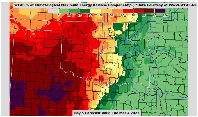
Given the absence of meaningful rainfall across western Oklahoma, Energy Release Component values have steadily increased. In the graphic to the right is the forecast ERC Percentile ranking for Tuesday, showing much of western Oklahoma eclipsing the 70th percentile and 80th percentile in the far west and southwest. Fires occurring in this environment will require additional resources and extended resource commitment to fully contain going wildfires due to increased resistance to control, which is one of the contributors to overall fire suppression difficulty. This reinforces the criticality of location, amount, and duration of rainfall that may occur Sunday and Monday.
County Burn Bans: None – Click HERE for the most current burn ban information.
See the original Oklahoma Forrestry Service’s Fire Situation Report here.


