Oklahoma’s fire danger is poised to escalate as dry and breezy conditions return, following a brief respite provided by eastward-moving rainfall. While yesterday’s precipitation significantly reduced fire activity and aided in containing several large blazes, the state is now bracing for increasing risks.
The recent rainfall has created a temporary window of relief, resulting in “light initial attack activity in the state and supported containment of several large fires occurring in recent days.” However, this reprieve is expected to be short-lived.
“Although cooler temperatures are forecast for today, dry and breezy conditions will prompt drying conditions today over dormant fuels setting the stage for increasing fire danger indices Thursday and Friday,” officials warn.
A Fire Weather Watch has been issued for parts of the Oklahoma Panhandle for tomorrow, with “elevated fire weather across much of western and northern Oklahoma.” This indicates a heightened risk of wildfires in these regions.
“Initial attack activity is expected to increase through the remainder of the workweek ahead of another chance of rainfall with highest probabilities across southern Oklahoma,” authorities anticipate.
Today’s weather conditions are particularly concerning. “Low dewpoint temperature today will support strong drying conditions as most locations in Oklahoma will see afternoon relative humidity values dip below 30% this afternoon and observations in the teens in western Oklahoma,” the forecast indicates. “Winds will remain rather stout through much of the day gradually decreasing from west to east through day into the evening.”
While “initial attack activity, while challenging, is expected to be successful with some large fire potential present,” firefighters are being cautioned about the terrain. “Firefighters are reminded that recent rainfall has created soft ground in many areas that may limit or even prohibit engine access to firelines.”
To mitigate these challenges, firefighters are urged to “identify existing features that may be used to contain fires such as roads, wet drainages, fuel type changes, ag fields, etc.”
Residents are advised to exercise caution and remain vigilant as fire danger increases. Pay close attention to local fire warnings and avoid activities that could spark wildfires. Windy conditions are expected to stick around through the weekend.
- Oklahoma Panhandle/Northwest Oklahoma: A chilly start will give way to temperature 53°-57° under clear skies and
afternoon relative humidity values 16-23%. Fine-dead fuel moisture will settle in around 5% this afternoon under drying conditions yielding increasing fuel receptiveness. Generally northwest winds in the area will be sustained 7-14 mph with some higher gusts in the northwest counties above 20 mph. One exception will be in Cimarron County where winds will relax as they become southwesterly this afternoon. On fires that do become established, rangeland fuels will exhibit head fire rates of spread 85-130 ft/min with flame lengths 9-11 ft. Initial attack efforts should be successful with limited large fire potential. - Western Oklahoma: Temperature 55°-63 under clear skies and afternoon relative humidity values 16-22% will support rapid drying conditions and increasing fuel receptiveness as breezy winds continue. Fine-dead fuel moisture will register 5% across much of the area with some pockets of 4% observation likely. Northwest winds 10-15 mph with some gust nearing 25 mph this afternoon will support moderate to rapid rates of fire spread. Rangeland fuels where grazing has been absent will support head fire rates of spread 110-160 ft/min and flame lengths 10-13 ft during peak burning conditions this afternoon. Winds are expected to relax after sunset offering good initial attack probability of success although a large fire (>300 acres) cannot be ruled out.
- Central Oklahoma: Solidly wetting rainfall amounts over the last three days has improved composite fuel moisture
although drying conditions today through Friday will support gradually increasing wildfire occurrence where wet ground will hamper fire engine access. Temperature in the low- to mid-50°s under clear skies coupled with relative humidity values 20-26% will serve to enhance drying of fine fuels with 1-Hr fuel moisture this afternoon tapping 5% at many locations. Northwest winds sustained 14-19 mph into the afternoon gusting 21-29 mph will result in moderate to rapid rates of spread in tall-grass fuels where grazing/haying has been absent. In tall-grass dominated fuelscapes, head fire rates of spread 110-160 ft/min are likely with flame lengths 10-13 ft. Note that on fires that become fully established in a free burning state will have potential to produce ROS +/-200 ft/min and FL 14-17 ft. Mixed fuels and timber fuels will exhibit moderated fie behavior offering good opportunity for initial attack success. Winds are expected to relax into the evening again boosting probability of successful initial attack.
- Eastern Oklahoma: Rainfall amounts of an inch or more wee common from yesterday’s storm system resulting in a good wetting of wildland fuels. Drying conditions will develop today with temperatures in the 50°s under clear skies and relative humidity values dipping below 30% in many areas. Northwest winds will remain rather stout through the day sustained 14-20 mph gusting at times near 30 mph further enhancing fuel drying. Firefighters should expect erratic burning conditions and the highest fire behavior indices in unsheltered, grass-dominated fuels. Tall grass fuels will exhibit max rates of spread at 150 ft/min and flame lengths +/-14 ft. Mixed and timber-litter fuels will offer muted fire behavior and excellent probability of initial attack success

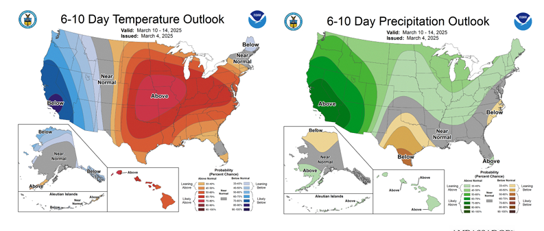
Outlook: Following the drying conditions today, dry-return flow on Thursday will support the expectation of increasing wildfire occurrence. Fortunately, we will see some mis-alignment in the fire environment given heavier cloud cover that will prevent 1-Hr fuel moisture from reaching full potential. Nonetheless, high fire danger indices are expected across western Oklahoma including the Oklahoma Panhandle where a Fire Weather Watch is currently in effect for Thursday. Fire danger continues on Friday as a cold front moves into the state increasing large fire potential while significant fire potential remains limited. Optimism for another round of rainfall, lacking the severe component this time, enters the forecast on Saturday with emphasis across the southern regions of Oklahoma. Recent rains have calmed the build-up of concerning Energy Release Comopnent and further improvement could come with weekend rains before another period of increasing fire dange develops next week. The 6-10 Day Temperature and Precipitation Outlooks point to warm and dry conditions across the state boosting fire danger and the expectation of increasing wildfire occurrence and large fire potential.