

Statewide Discussion: Predominantly dry conditions today across Oklahoma will continue to prime wildland fuels, supporting increasing wildfire occurrence coupled with enhanced resistance to control. While a few rain/storm opportunities appear in the near-term forecast, those opportunities will be reserved for the southeastern counties and extreme eastern Oklahoma. Otherwise, concern continues to increase as a powerful windstorm will traverse the Southern Plains on Friday, prompting very-high to extreme fire danger across Oklahoma. Fire danger concern will continue through the weekend ahead of another concerning period of fire-effective weather over wildland fuels exhibiting high resistance to control.
Today: Continued drying conditions have primed wildland fuels, supporting increasing initial attack and emergence of large wildfires (>100 acres in timber or >300 acres grass/brush). Overnight moisture recovery was slightly improved over recent days, although dry air will overspread most of Oklahoma today, supporting very receptive fine fuels. Wind speeds will support moderate rates of spread, facilitating a good probability of successful initial attack efforts. A disturbance approaching from the west will spur some potential for isolated storms in southeastern Oklahoma.
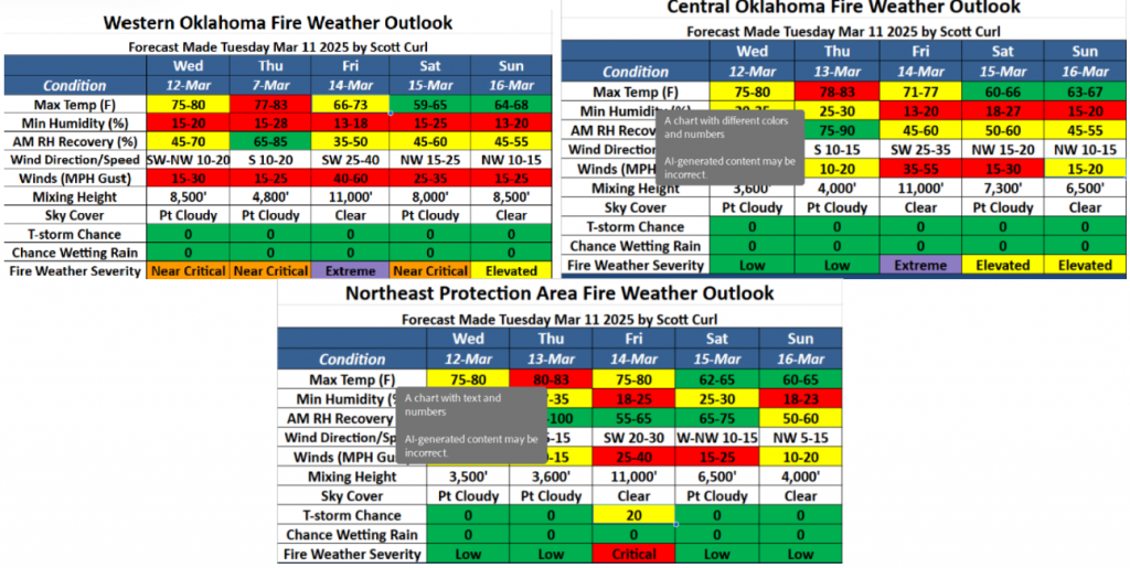
- Northern/Northeastern Oklahoma: Wildland fire activity increased across the area yesterday with both wildfire and
prescribed/controlled burning on the landscape. Today, temperatures 75°-82°with some sky cover and relative humidity values 20-27% will yield fine-dead fuel moisture at 4-5%. Southerly winds are expected to remain in place through the burning period, sustained 7-12 mph with some higher gusts this afternoon. Grass-dominated fuels in the area will support head fire rates of spread 65-120 ft/min and flame lengths 11-15 ft. The expectation of very good overnight moisture recovery and calm winds into the overnight hours will support a very good probability of a successful initial attack. - Northwestern/Oklahoma Panhandle: Under mostly clear skies today, temperature will warm into the upper-60°s in the western Panhandle to the mid-70°s in the northwestern counties. Afternoon relative humidity values will sink into the 10-20% range, yielding receptive fine-dead fuel moisture values at 3-4%. Light winds this morning will become strongest in the Panhandle counties, where northerly winds sustained around 17 mph with some gusts nearing 25 mph will support head fire rates of spread in rangeland fuels 116-180 ft/min with flame lengths +/-12 ft. Variable winds in the northwestern counties will be eerily calm at times, limiting fire spread potential to less than 95 ft/min, offering very good opportunity for initial attack success.
- Western/Southwestern Oklahoma: Above normal temperatures combined with another dry afternoon will continue to degrade the benefit of recent rainfall and continue to prime fuels to support increasing fire behavior potential. Temperature 75°-82° under partly-cloudy skies with afternoon relative humidity values 11-19% will yield fine-dead fuel moisture at 3-4%. West to southwest winds sustained 11-18 mph with some gusts 25 mph along the Red River will support moderate rates of fire spread in rangeland fuels. During peak burning conditions, head fire rates of spread 105-170 ft/min are likely coupled with flame lengths 10-12 ft. Overnight moisture recovery is not expected to be very good, facilitating accelerated drying, although winds do relax, offering a good opportunity for a successful initial attack.
- South-Central/Southeastern Oklahoma: Composite fuel moisture continues to dry down following recent rains. An
abundance of prescribed and controlled burning yesterday will merit thorough mop-up ahead of strengthening fire weather later this week. Today, temperatures in the low-80°s with afternoon relative humidity values ranging from 14% along I-35 to 40% in far southeastern Oklahoma as rain/storm chances develop. South-southwest winds sustained 9-13 mph with some higher gusts will support moderate rates of spread in grass fuels at +/-95 ft/min with flame lengths +/-9 ft. Timber litter will continue to exhibit muted fire behavior with ROS +/-20 ft/min and FL 3 ft, offering good initial attack opportunity
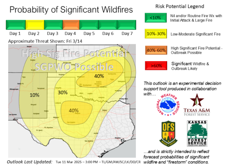
Outlook: Wildland fuels continue to register intensifying Energy Release Components ahead of ominous fire weather coming Friday when the probability of significant fire occurrence and wildfire outbreak continues to increase. The Friday weather system is analogous to past weather events occurring in March that have resulted in dangerous wildfire occurrences. Following today, we hold elevated fire weather in place across Oklahoma on Thursday although relative humidity values will be somewhat improved. Nonetheless, increasing wildfire occurrence is expected and those fires will exhibit increasing resistance to control. Prescribed fire and controlled burning activities are strongly discouraged for the remainder of the week as we enter a period of persistent fire danger concern that continues into next week.
Based on updated fuels and weather intelligence, the OFS working alongside the National Weather Service as well as Texas A&M Forest Service and Kansas Forest Service, has increased the probability of significant wildfire potential into the ‘High’ category, emphasizing the possibility of a Southern Great Plains Wildfire Outbreak.
County Burn Bans: None – Click HERE for current burn ban information


