

To view the latest Oklahoma drought map, CLICK HERE.
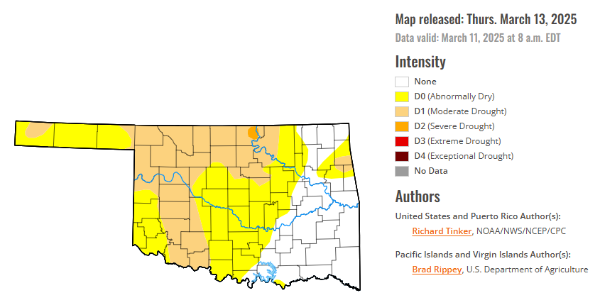
According to the latest Oklahoma drought monitor report, exceptional drought remains at zero percent, unchanged from the start of the calendar year.
Extreme drought or worse conditions remain at zero percent, unchanged since the week of October 29, 2024.
Severe drought or worse conditions remain at 0.33 percent, unchanged since January 2.
Moderate drought or worse conditions have increased to 32.13 percent, up from 25.66 percent last week.
Abnormally dry or worse conditions have decreased to 71.07 percent, down from 80.89 percent last week.
According to the 6-to-10-day precipitation outlook map, most of the state is leaning below a 33 – 40% chance of precipitation through March 22. A small southern pocket in Southwest Oklahoma is leaning below a 40-50% chance of precipitation. The central section of the panhandle near normal chances of precipitation, while the far western tip is leaning above a 33-40 % chance of precipitation through that March 22 date.
To view the United States Drought Map, CLICK HERE.
Last week brought substantial precipitation (over 1.5 inches) to parts of western Washington, the central and southern Sierra Nevada, southwestern California, portions of the western Mississippi Valley from southern Minnesota into Louisiana and eastern Texas, a swath across the Gulf Coast and South Atlantic States, and the eastern tiers of the mid-Atlantic and Northeast. The highest totals (3 to locally 8 inches) were recorded across northern Florida and adjacent Georgia, and northwesternmost Washington. More than 3 inches also fell on scattered small patches of the Sierra Nevada, in a swath from central Mississippi through western Georgia, and central South Carolina. In contrast, only a few tenths of an inch of precipitation barely dampened most of the Ohio Valley and adjacent Appalachians, and from the central and western Plains to the Pacific Coast, although some of the higher elevations of the central Rockies recorded moderate amounts. Central and southern portions of the Florida Peninsula also recorded a few tenths of an inch at best. Meanwhile, it was an abnormally warm week across the entire northern tier of the country outside far western Washington, from the central Plains eastward through the mid-Atlantic, and across central and southern Texas. Daily maximum temperatures averaged 12 to 15 deg. F above normal for the 7-day period over the central and northern Dakotas and adjacent Minnesota. Somewhat below-normal temperatures were observed from the central Rockies westward to the Pacific Coast and southward to the Mexican Border.
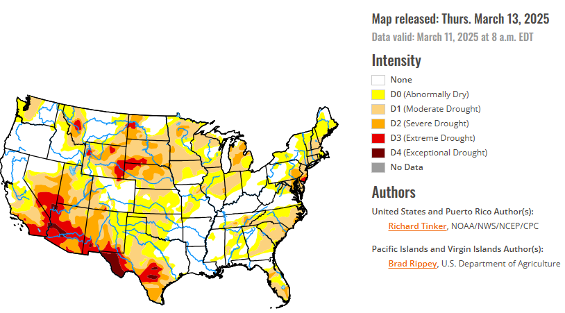
In the Southern Plains, subnormal precipitation in eastern and southern Tennessee led to some expansion of D0 and D1 there, but most of the central and eastern South Region, from eastern portions of Oklahoma and Texas through Mississippi and western Tennessee, is free of dryness and drought. There are a few isolated areas of dryness across Mississippi, and abnormal dryness is also affecting extreme northwestern Arkansas. But Louisiana is one of only 2 states completely free of dryness and drought on the Drought Monitor. In contrast, some degree of dryness covers the central and western sections of Texas and Oklahoma. Rainfall along the Red River (south) led to some improvements across southern Oklahoma and adjacent Texas, but some degree of dryness remains on the map there. Other parts of Texas and Oklahoma saw little or no precipitation, leading to areas of dryness and drought intensification. The greatest drought intensity (D4, exceptional drought) covers a large part of the Big Bend as well as portions of central Texas, were patches of D4 are surrounded by a large area of D3 (extreme drought). Since mid-December, less than 5 percent of normal precipitation has fallen on the Big Bend while large sections of central, southern, and western Texas reported less than half of normal since mid-January. Generally 20 to 50 percent of normal for the 2-month period was also observed across the Oklahoma Panhandle and adjacent areas. With dry weather, seasonably increasing temperatures, and periods of high winds, conditions could deteriorate rapidly across central and northwestern Texas, reaching into parts of adjacent Oklahoma and New Mexico.
In the High Plains, light to moderate precipitation fell on parts of the region last week, reducing dryness and drought severity in the middle of the Region across several patches in Wyoming, adjacent northern Colorado, part of north-central Nebraska, and a small area in northwestern Kansas and adjacent areas. Farther south, continued subnormal precipitation induced a broad area of deterioration in central and western Kansas and smaller portions of southern Colorado, but heavier amounts eased conditions in eastern Kansas. The depiction across the Dakotas did not change. During the last 90 days, less than half of normal precipitation was measured across south-central and southwestern Kansas, southeastern Colorado, and a few patches across the Dakotas. At the same time, much of Wyoming, central and northeastern Colorado, and a few swaths from northern Kansas through Nebraska and southwestern South Dakota recorded above-normal amounts. Southwestern Kansas and southeastern Colorado were particularly dry during the last 90 days, receiving less than 25 percent of normal.
In the West, areas of moderate precipitation, with isolated heavy amounts, affected the Sierra Nevada, southwestern California, western Washington, and some of the higher elevations across Arizona, Utah, eastern Nevada, and southern Idaho. Most of the large West Region, however, recorded several tenths of an inch or less. Similar to the situation across central and western Texas, dryness and drought may be intensifying at a fairly quick clip across New Mexico, and a large part of the state deteriorated by one category this week. That includes a larger area of D3 along the southern tier of the state, with a small area of D4 introduced in the state’s southwestern interior. Farther west, no intensification was noted this week, but a broad area of D3 and D4 persists across southern California, southern Nevada, and much of Arizona. From central sections of Utah and Nevada southward to the Mexican border and southwestward through southern California, less than half of normal precipitation has fallen since mid-December. The lowest totals (just 2 to 25 percent of normal) extend across the southern Four Corners area. Conditions are considerably better north of Utah and central Nevada, with D3 restricted to a small part of western Montana, and more than half of the area free from dryness and drought.
Looking ahead, the March 13-17 period starts out unusually mild in a large part of the central and eastern U.S. while relatively cool weather stretches from the Rockies to the Pacific Coast. On March 13, temperatures may reach the upper 70’s deg. F as far north as central South Dakota, central Indiana, West Virginia, and North Carolina. Portions of central and southern Texas are expected to top 90 deg. F. It’ll be a little cooler in the mid-Atlantic and Northeast, with highs in the low 60’s deg. F at best, and probably not above 45 deg. F in most of New England. As the period progresses, warm air pushes south and east toward the Atlantic Ocean while a shot of cold air invades the northern Plains. Lows are expected to drop into the teens in parts of the northern Plains that are expected to top 75 deg. F just two days earlier. The cold intrusion looks to be short-lived, with the air mass moderating as it pushes east. On March 17, warmer weather is expected to again build into the Plains. Meanwhile, the western half of the CONUS remains relatively cool. Much of the Sierra Nevada, Cascades, Pacific Northwest Coast, and northern California are anticipating more than 4 inches of precipitation for the 5-day period, with 5 to locally 8 inches possible in northwestern California and adjacent Oregon. Elsewhere from the Rockies westward, fairly widespread light to moderate precipitation is forecast, with heavier totals of 1.5 to locally 4.0 inches falling on some of the higher elevations (particularly in central and northern Idaho) and parts of the central and southern California Coastline. Most lower elevations should expect lesser amounts of several tenths to an inch. Farther east, a swath of heavy rain is anticipated from the lower Ohio Valley southward into portions of the Gulf Coast States. More than 1.5 inches is forecast there, with amounts exceeding 3 inches possible in northeastern Mississippi, northern Alabama, and central Tennessee. Moderate amounts of at least 0.5 inch should fall elsewhere from the Mississippi River to the Atlantic Seaboard, with lesser totals expected over most of Maine, southern Florida, and the western Great Lakes. In the middle of the country, at least a few tenths of an inch of precipitation are forecast for the east-central and northeastern Great Plains and the Upper Mississippi Valley, with amounts approaching of slightly exceeding an inch over most of Minnesota and adjacent portions of South Dakota and Iowa. Dry weather is anticipated across the High Plains and the southern half of the Great Plains, with a few tenths of an inch falling at best.
The Climate Prediction Center’s 6-10 day outlook valid March 18-22, 2025 favors a continuation of below-normal temperatures from the Rockies westward, and warmer than normal weather over most of the central and eastern states. Odds for unusual warmth top 60 percent from the Ohio Valley and mid-Atlantic northward to the Canadian border while there is over a 70 percent chance of unusually cool conditions in the western Great Basin. Hawaii has significantly enhanced odds for above-normal temperatures (over 60 percent), and the dry areas of southern Alaska should also average warmer than normal, although with lower probabilities. Meanwhile, subnormal precipitation continues to be favored across most of Texas and Oklahoma, and there are slightly enhanced chances for drier than normal weather over part of North Dakota and along the South Atlantic Seaboard. The rest of the country should average near- or wetter-than-normal, with the best odds for surplus precipitation over and near the Pacific Northwest. Above-normal precipitation is also favored for the western half of Hawaii and for the dry areas in Alaska.
To view the 6-10 Day Precipitation Outlook Map, click here.
To view the 6-10 Day Temperature Outlook Map, click here.
To view the Monthly Drought Outlook Map, click here.


