OFS STATISTICS for March 15, 2025 / OFS Preparedness Level: 1 – 2 – 3 – 4 – 5
NE Area – 2 Fires Burned 206.5 Acres (Cause: 2-Incendiary)
EC Area – 4 Fires Burned 116.6 Acres (Cause: 3-Escaped Debris, 1-Incendiary)
SE Area – No New Activity
Ongoing Large / Significant Fire Activity within the OFS Protection Area:
- Ketcher Hollow Fire (Latimer County) – 101 Acres / 70% Contained
- Tully Hollow Fire (Adair County) – 205 Acres / 50% Contained
- Brushy Church Fire (Pittsburg County) – 240 Acres / 35% Contained
- Big Draw Fire (McCurtain County) – 146.4 Acres / 50% Contained
- Cherry Tree Fire (Adair County) – 109.0 Acres / 50% Contained
- Low Gap Lookout Fire (Haskell County) – 394 Acres / 80% Contained
- Hamby Ridge Fire (Delaware County) – 706 Acres / 70% Contained
- Scraper Hollow Creek Fire (Cherokee County) – 165 Acres / 70% Contained
- Gravel Pit Fire (Adair County) – 124 Acres / 90% Contained
- Eagle Bluff Fire (Cherokee County) – 145 Acres / 80% Contained
- Slickfoot Fire (Delaware County) – 289 Acres / 100% Contained
- Scraper Hollow Creek Fire (Cherokee County) – 165 Acres / 90% Contained
- New State Fire (Pittsburg County) – 200 Acres / 90% Contained
Fire Activity with OFS Response Outside of the Protection Area: 4 Fires Burned 49,975 Acres Acres - 840 Road Fire (Roger Mills/Dewey County) – 27,025 Acres / 20% Contained
- Camargo Fire (Dewey County) – 5,725 Acres / 20% Contained
- Little Salt Creek Fire (Pawnee County) – 11.192 Acres/Multiple Structures / 10% Contained
- Hickory Hills Fire (Oklahoma County) – 6,643 Acres/13 Structures/ 25% Contained
- 33 Road Fire (Logan/Payne Counties) – 33,475 Acres/50 Structures / 10% Contained
- Timberline Fire (Cleveland County) – 98 Acres/17 Structures / 75% Contained
- Post Oak Fire (Cleveland County) – 204 Acres / 70% Contained
- Onyx Fire (Cleveland County) – 380 Acres / 60% Contained
- Station 2 Fire (Cleveland County) – 583 Acres/8 Structures / 50% Contained
- 1980 Road Fire (Beckham County) – 2,000 Acres / 40% Contained
- Euchee Valley Fire (Payne County) – 8,512Acres/9 Structures / 50% Contained
- Hellroaring Creek Fire (Pawnee County) – 10,186 Acres / 50% Contained
- Stripes Fire (Creek County) – 436.0 Acres / 75% Contained
Fire Department Activity: Heavy Initial Attack (26 Fires Burning 49,990.1 Acres) Source: OFS Fire Department Wildfire Reporting Tool
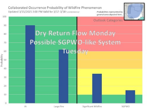
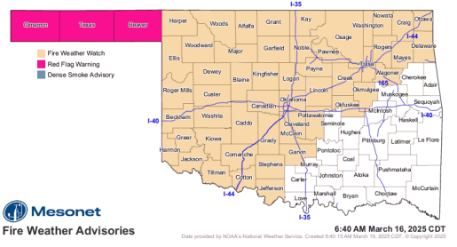
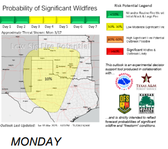
Statewide Discussion: Critical fire weather over readily receptive fuels will again develop in the Oklahoma Panhandle today while elevated concern remains in place statewide with very dry air overspreading the state. Oklahoma will continue to endure a period of notable fire danger entering into next week with a return to dry, south winds on Monday priming much of Oklahoma for another round of extreme fire danger for portions of the state. Monday and Tuesday will present fire environment conditions consistent with past wildfire out breaks on the Southern Great Plains coupled with escalating probability of significant fire occurrence (fires greater than >5,000 acres) targeting central and western Oklahoma. A Fire Weather Watch is in effect for both Monday and Tuesday for areas of the state both north of I-44 and counties immediately south of I-44. Over the course of the next several days, there is little, if any, opportunity for improvement in fire weather or wildland fuels, driving increasing rates of new wildfire occurrence with large and significant fire potential in place.
Today: Red Flag Warning in effect today until 8:00 PM for the Oklahoma Panhandle counties. A Fire Weather Watch is in effect for a large portion of the state for both Monday and Tuesday ahead of the next dry storm system ratcheting up fire danger in Oklahoma. Relative humidity values will drop below 20% statewide testing recent fires with enhanced burning conditions. This will, however, assist in identifying potential problem areas ahead of challenging days to come. In general, winds will be calm today for March in Oklahoma limiting fire spread. Initial attack activity is very likely to be heavy although initial attack efforts will be largely successful. Continued commitment to improving containment lines, mop-up and patrol on current wildfire incidents will be paramount to limiting potential for escape fires tomorrow and Tuesday.
OFS Resources Outside of OFS Protection: Resource Hotline (800) 800-2481
- OFS has 5 Suppression Groups assigned to ongoing wildfires.
- Burns Flat – Aerial Supervision Module and 2 CL415 Scoopers
- OHP with OFS Operations Chief – Reconnaissance and Mapping
Fire Behavior:
- Northwestern/Oklahoma Panhandle: Red Flag Warning in the Oklahoma Panhandle Counties today. Following a chilly start, temperature will warm into the mid-60°s under mostly-clear skies with afternoon relative humidity values 9-9% following marginal to moderate overnight moisture recovery. Fine-dead fuel moisture will become very receptive with 3% observations across the area and local 2% observations likely in the Warned Area. Given persistent and accelerated drying, composite fuel moisture reflected in Energy Release Component is climbing into the +80th Percentile range translating to increasing resistance to control and heavier resource commitment on incidents. West-northwest winds sustained 10-14 mph with some higher gusts will support head fire rates of spread in rangeland fuels generally 148-187 f/min and flame lengths 12-15 ft in rangeland fuels noting that where fuels and topography are aligned with wind direction ROS exceeding 200 ft/min is likely. Marginal overnight moisture recovery is expected to be marginal spurring an extended burning period although winds will remain lighter limiting fire spread potential in the overnight hours.
- North-Central/Northeastern Oklahoma: Under clearing skies this afternoon, temperature 61°-64° with relative humidity values 14-18% will yield very receptive fine-dead fuel moisture at 4% with some 3% observations likely. Fortunately light and variable winds becoming westerly generally less than 10 mph will limit fire spread potential to less than 100 ft/min with flame lengths +/-10 ft in grass-dominated fuels. Timber and brush fuel types will exhibit ROS 25-50 ft/min and FL 6 ft offering good probability of successful initial attack. Note that torching and short-range spotting remains likely.
- Western/Southwestern Oklahoma: Marginal overnight moisture recovery will spur an early start to the burning period as temperature warms into the mid- to upper-60°s under clearing skies with afternoon relative humidity values 13-19% yielding 3% 1-Hr fuel moisture. Light and variable winds through much of the day becoming west-southwesterly late in the burning period will hold rangeland fire behavior to +/- 90 ft/min and flam lengths +/-9 ft offering very good probability of successful initial attack today.
- South-Central/Southeastern Oklahoma: Temperature in the mid- to upper-60°s with afternoon relative humidity values 14-18% will support extremely receptive fine-dead fuel moisture observations for the area at 3% prompting the expectation for notable increase in new wildfire occurrence. Light and variable winds becoming southwest late in the burning period generally less than 10 mph will limit fire spread potential. Grass-dominated fuels will exhibit head fire rates of spread <90ft/min with flame lengths +/-10 ft. Timber and brush fuel types will support ROS +/-40 ft/min and FL 5 ft. Problematic fire behavior should be anticipated in juvenile pine plantations and where juniper is present exhibiting torching and short-range spotting.
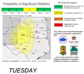
Outlook: A dry-return flow weather pattern tomorrow (Monday) is a recognizable weather pattern that is known to result in heavy initial attack activity and troublesome wildfire occurrence when occurring over dry, available fuels. The highest probabilities on Monday will reside along and north of I-44 presenting increasing concern for recent fire activity to present elevated risk of escape. Tuesday, will also present escalating potential for significant fire occurrence and potential wildfire outbreak with focus in western and northwestern Oklahoma.
County Burn Bans: Click HERE for current burn ban information.