OFS STATISTICS for March 17, 2025 / OFS Preparedness Level: 1 – 2 – 3 – 4 – 5
NE Area – 6 Fires Burned 267.4Acres (Cause: 2-Escaped Control Burn, 1-Escaped Debris, 3-Incendiary)
EC Area – 7 Fires Burned 1,971.9 Acres (Cause: 3-Escaped Debris, 1-Incendiary)
SE Area – 5 Fires Burned 253.0 Acres (Cause: 1-Escaped Control Burn, 1-Escaped Debris, 2-Incendiary)
Ongoing Large / Significant Fire Activity within the OFS Protection Area:(>100 Acres Timber / >300 Acres Grass/Brush)
- Dirty Pine Fire (Pushmataha County) – 157 Acres / 50% Contained
- Venison Hollow Fire (Adair County) – 402 Acres / 70% Contained
- Doublehead South Fire (Adair County) – 150 Acres / 50% Contained
- Black Fox Fire (Sequoyah County) – 106 Acres / 65% Contained
- Flying J Fire (Latimer County) – 1,154 Acres / 50% Contained
- Plan B Fire (Latimer County) – 800 Acres / 50% Contained
- Ketcher Hollow Fire (Latimer County) – 101 Acres / 70% Contained
- Tully Hollow Fire (Adair County) – 205 Acres / 75% Contained
- Brushy Church Fire (Pittsburg County) – 240 Acres / 85% Contained
- Big Draw Fire (McCurtain County) – 146.4 Acres / 100% Contained
- Cherry Tree Fire (Adair County) – 109.0 Acres / 80% Contained
- Low Gap Lookout Fire (Haskell County) – 394 Acres / 90% Contained
- Hamby Ridge Fire (Delaware County) – 706 Acres / 100% Contained
Fire Activity with OFS Response Outside of the Protection Area: 4 New Fires Burned 571.0 Acres
- Ranch Creek Road Fire (Pawnee County) – 513 Acres / 25% Contained
- 840 Road Fire (Roger Mills/Dewey County) – 27,855 Acres / 40% Contained
- Camargo Fire (Dewey County) – 5,725 Acres / 40% Contained
- Little Salt Creek Fire (Pawnee County) – 11,190 Acres / 25% Contained
- Hickory Hills Fire (Oklahoma County) – 6,643 Acres / 35% Contained
- 33 Road Fire (Logan/Payne Counties) – 32,990.6 Acres/50 Structures / 25% Contained
- 1980 Road Fire (Beckham County) – 2,000 Acres / 65% Contained
- Euchee Valley Fire (Payne County) – 8,512 Acres / 65% Contained
- Hellroaring Creek Fire (Pawnee County) – 10,186 Acres / 80% Contained
Fire Department Activity: Heavy Initial Attack (35 Fires Burning 54,857.65 Acres) Source: OFS Fire Department Wildfire Reporting Tool
** Statistics above include fire reporting submitted by fire departments from fire activity on 03/14/2025**
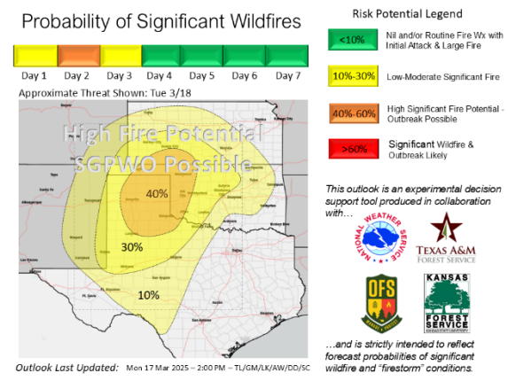
Statewide Discussion: Heavy resource commitment yesterday was dedicated to improving containment on existing fires, battling flare-ups from some of those fires and responding to new wildfire incidents. Today, those fires will be challenged by yet another round of extreme fire weather over critically dry fuels in much of Oklahoma. There is a high significant fire
occurrence (>5,000 acres) probability in western Oklahoma with those probabilities extending into the central regions of the state. Another Wildfire Outbreak is possible and given the approaching dry, cold front, a Megafire (burning <100,000 acres) cannot be ruled out. Near-critical fire weather and increasingly resistant to control fire behavior will remain in place through Friday statewide.
Firefighters – Extreme rates of spread on established wildfires will outpace suppression capability and prohibit frontal assault. Anchor the fire near the heel and work the flanks progressing toward the head. When engaged in structure protection, ensure that escape routes to safety zones are established and made known. Take a minute to make a plan rather than making a plan each minute.
OFS Resources Outside of OFS Protection: Resource Hotline (800) 800-2481
- OFS has 5 Suppression Groups assigned to ongoing wildfires.
- Burns Flat – Aerial Supervision Module and 2 CL415 Scoopers – Wind Speed and Gust Spread may prohibit operations.
- OHP with OFS Operations Chief – Reconnaissance and Mapping
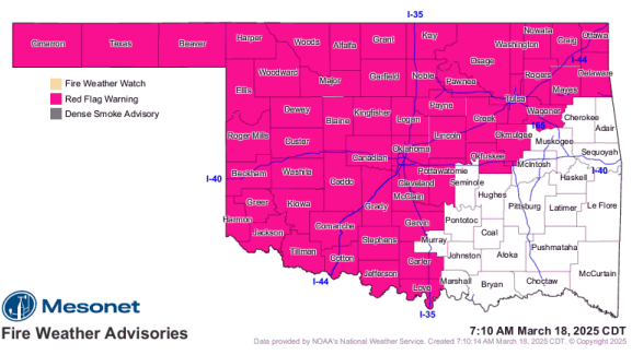
Today: Red Flag Warning in effect today until 8:00 PM for most of Oklahoma. Critical to Extreme fire weather will develop early in the burning period with poor overnight moisture recovery in many areas of the state ahead of increasing southwest to west winds coupled with very dry fuels as relative humidity again falls below critical threshold. A dry cold front will migrate into the state in the early morning hours ushering in a shift to northwest winds topping High Wind Warning threshold and potentially explosive fire growth with extreme rates of fire spread. The highest concerns today are two-fold: 1) Existing fires will be challenged by critical fire weather with many of those fires in high-density population areas, and 2) Northwestern/Western Oklahoma where there is a high probability of significant wildfire occurrence.
Fire Behavior:
- Northwestern/Oklahoma Panhandle: Red Flag Warning. Poor overnight moisture recovery will facilitate very active fire behavior potential this morning with conditions rapidly deteriorating through the day ahead of a dry cold front in the overnight hours. Relative humidity this morning around 20% at some locations will dip into the 8-15% range this afternoon as temperature heats up to 75°-90°. There will be some cloud cover and bowing dust providing some fuel shading although fine dead fuel moisture will register 2-3% this afternoon. Generally southwest winds this morning will intensify through the day sustained 24-35 mph gusting in excess 45 mph during peak heating today. Rangeland fuels will readily exhibit extreme fire behavior with rates of spread 320-540 ft/min (3.6-6.1 mph) and flame lengths 17-24 ft. Where brush fuels, including juniper, are present, expect torching and crown runs generating long-range spotting to 0.5 miles. A cold front will cross the area around midnight with ends becoming northwest challenging the east flanks of any going fire.
- North-Central/Northeastern Oklahoma: The existing fires on the landscape will be significantly challenged today with critical to extreme fire weather including stout winds. Temperature in the 80°s with some sky cover and relative humidity values 17-27% will yield fine-dead fuel moisture at 3-4% this afternoon. South-southwest winds sustained 19-25 mph with some gusts over 35 mph will support extreme rates of fire spread and torching/crowing with spotting distances +/- 0.25 miles. Grass-dominated fuels will support head fire rates if spread 220-356 ft/min (2.5-4.0 mph) and flame lengths 14-19 ft. Timber fuels will exhibit ROS 38-80 ft/min and FL 5-7 ft. The cold front will migrate over the area in the early morning hours potentially supporting rapid fire growth on the east and south flanks of any going fire.
- Western/Southwestern Oklahoma: While some areas have slightly lower fuel loading, rangeland fuels overall will exhibit extreme rates of fire spread on any established fire. Temperature will warm into the low-80°s to 90° with some scattered sky cover and relative humidity values 8-16% yielding fine-dead fuel moisture at 2-3%. Southwest winds will intensify into the afternoon sustained 22-30 mph gusting to near 50 mph. Rangeland fuels will support head fire rates of spread 300-440 ft/min and flame lengths 15-21 ft. Anticipate torching and spotting in brush fuel types up to 0.5 miles. The frontal boundary will arrive in the early morning hours with intense wind field potentially blowing out eastern flanks of going fires.
- South-Central/Southeastern Oklahoma: Recent fire activity has proven challenging although primarily successful during initial attack. Large fire probabilities have notably increased. Today, temperature 78°-83° and afternoon relative humidity 25-32% will yield fine-dead fuel moisture in the 6-7% range. Southerly winds sustained 17-22 mph gusting 30 mph will support problematic rates if fire spread. Grass-dominated fuels will support head fire rates of spread 1503-219 ft/min with flame lengths 11-15 ft. Timber fuel types will exhibit ROS 30-50 ft/min and FL 3.5-8 ft. Brush fuel types will support problematic fire behavior with torching and spotting.
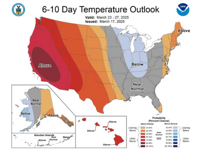
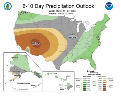
Outlook: On the heels of dangerous fire conditions today, dry conditions prevail through the week with elevated to near-critical fire weather fully anticipated. The next opportunity for any rainfall develops late in the weekend and is confined, at this time, to eastern Oklahoma. Extended range outlooks do not offer much optimism for relief pointing to above normal temperature and below normal rainfall in the 6-10 Day Outlook.
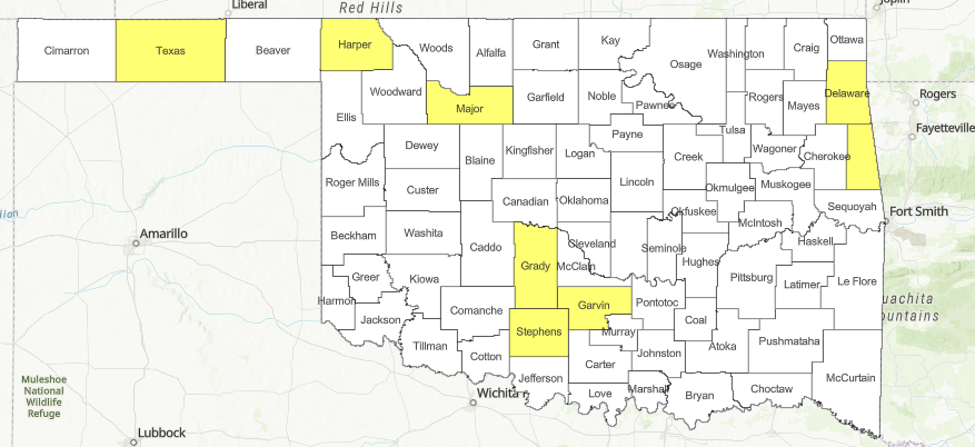
County Burn Bans: Click HERE for current burn ban information.