Fire Department Activity: Heavy Initial Attack (35 Fires Burning 54,857.65 Acres)
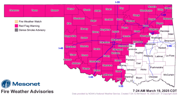
Statewide Discussion: A continuous burning period through the overnight hours with relative humidity values in the single digits driving across the state overnight as a dryline pushed east ahead of a strong cold front with very strong gusty winds. OFS and Fire Department personnel have been responding to new fires, some large, and tackling blow outs on some existing fires have taxed incident responders ahead of another concerning day with concerning fire danger. Strong winds through the day will continue to challenge control lines on current wildfire footprints from the last several days. Cooler temperatures, clouds and somewhat improved relative humidity values will offer little assistance in overall fire danger today given the composite fuel moisture values and persistent winds that will pose potential for rapid to extreme rates of fire spread again today. Fire danger will remain firmly in place through the week and weekend for most of Oklahoma noting that rain chances to build in this weekend in eastern Oklahoma.
OFS Resources Outside of OFS Protection: Resource Hotline (800) 800-2481
• OFS has 4 Suppression Groups assigned to ongoing wildfires.
• Burns Flat – Aerial Supervision Module and 2 CL415 Scoopers – Wind Speed and Gust Spread may prohibit operations.
• OHP with OFS Operations Chief – Reconnaissance and Mapping
Today: Red Flag Warning in effect today for a large area of Oklahoma. In the post-frontal environment trace amounts of rain/snow/sleet did fall in areas of western Oklahoma, and much cooler temperatures will prevail with improved relative humidity values. Very strong west to northwest winds and low composite fuel moisture will continue to support very active burning conditions challenging existing fires on the landscape as well as potential for extreme fire behavior on new fires that become established. The significant fire potential will be highest in southwestern Oklahoma where skies will clear and relative humidity values will fall back into critical level again. Winds do relax in the overnight hours with moderate overnight moisture recovery on tap improving opportunity for gaining containment on open wildfire incidents.
Fire Behavior:
• Northwestern/Oklahoma Panhandle: Red Flag Warning and High Wind Warning. A cold front moved through the area last night, bringing significantly cooler temperatures. This morning, relative humidity levels range from 50% to 87% in some locations but are expected to drop to the 25-30% range this afternoon as temperatures will be much cooler, between 35°F and 45°F. There will be cloud cover throughout the day, with a chance of light snow flurries, which could help replenish fine dead fuel moisture by up to 6-7% this afternoon. Northwest winds this morning are gusting over 40 mph, with some gusts exceeding 60 mph. Rangeland fuels are likely to exhibit extreme fire behavior, with spread rates between 561 and 850 feet per minute (7.0-9.6 mph) and flame lengths of 20-25 feet on fully established, free burning fires. In areas where brush fuels, including juniper, are present, expect torching and crown runs that may generate long-range spotting up to 0.5 miles. The strong cold front will continue moving quickly south and east early today. Gusty northwest winds will persist through the afternoon, though the stronger gusts will decrease during the afternoon. Light winds are expected early Thursday, but will shift to southerly and increase by Thursday afternoon.
• North-Central/Northeastern Oklahoma Red Flag Warning: Near-critical fire weather conditions are expected this morning due to gusty southwest winds and low humidity levels. As a result, the Red Flag Warning will remain in effect until 1 PM today. Later in the day, increasing humidity levels behind a cold front will help alleviate fire weather concerns, although gusty west to northwest winds are still anticipated. Temperatures will decrease throughout the day, and cloud cover will contribute to rising humidity levels. Fire weather conditions are expected to improve by mid to late afternoon as winds begin to weaken. This afternoon, temperatures will range from the 50s to 60s, with some cloud cover and relative humidity values between 20% and 30%. This will lead to fine-dead fuel moisture levels of 6-7%. Winds will shift to the west this morning after the passage of the cold front, becoming northwest in the afternoon. Morning winds will be sustained at 25-32 mph, with gusts exceeding 45 mph, which will support extreme rates of fire spread, torching, crowning, and spotting distances of approximately 0.25 miles. Grass-dominated fuels are expected to exhibit head fire rates of spread between 561 and 850 feet per minute (7.0-9.6 mph) and flame lengths of 20-25 feet on fully established, free burning fires. Timber fuels will show rates of spread of 46-70 feet per minute and flame lengths of 10-12 feet.
• Western/Southwestern Oklahoma – Red Flag Warning: This morning, relative humidity levels range from 50% to 60% in some locations but are expected to drop to the 25-30% range this afternoon as temperatures will be much cooler, between 45°F and 50°F. While some areas have slightly lower fuel loading, rangeland fuels overall will exhibit high rates of fire spread on any established fire. Mostly cloudy sky cover and relative humidity values 25-30% will yield fine-dead fuel moisture at 6%. Northwest winds will be sustained 30-35 mph gusting to near 50 mph. Rangeland fuels will support head fire rates of spread 308-453 ft/min (3.8-5.6 mph) and flame lengths 22-27 ft. Anticipate torching and spotting in brush fuel types up to 0.5 miles.
• South-Central/Southeastern Oklahoma – Wind Advisory: Recent fire activity has been challenging but has mostly been managed effectively during initial attacks. Today’s forecast indicates temperatures between 55°F and 60°F, with afternoon relative humidity dropping to 15% to 25%. This combination will lead to fine dead fuel moisture levels around 4% to 5%. In the morning, winds will be steady from the west at 15 to 20 mph, with gusts reaching up to 27 mph. By afternoon, the wind will shift to the northwest, potentially increasing rates of fire spread. Grass-dominated fuels will support head fire spread rates of 561 to 850 feet per minute (7.0 to 9.6 mph), generating flame lengths of 20 to 25 feet. Timber fuel types will demonstrate rates of spread of 46 to 70 feet per minute, with flame lengths of 10 to 12 feet. Additionally, brush fuels are likely to exhibit problematic fire behavior, including torching and spotting.
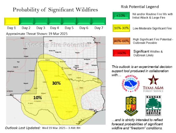
Outlook: Dry-return flow tomorrow will usher in much drier air across the state with relative humidity values below 25% statewide although lower wind speeds will relax fire spread potential when compared to previous days. Nonetheless, wildfires will present resistance to control as composite fuel moisture continues to degrade. Elevated fire weather over readily receptive fuels remains in place through the week and into Saturday ahead of some improving rain chances in eastern Oklahoma while central and western Oklahoma currently have very limited rainfall potential with no benefit from the forecast amounts.
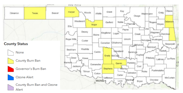
County Burn Bans: Click HERE for current burn ban information.