OFS STATISTICS for March 23, 2025 / OFS Preparedness Level: 1 – 2 – 3 – 4 – 5
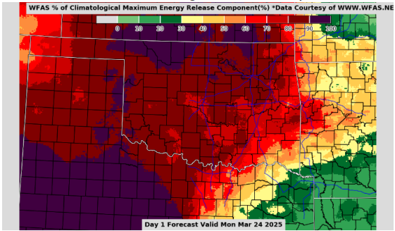
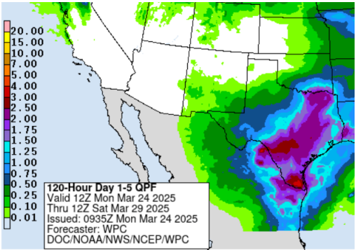
Statewide Discussion: Elevated fire weather indices over very dry, dormant fuels will hold fire danger concern in place across Oklahoma again today. Green-up in the cool-season herbaceous species has initiated along some roadsides, grazed pastures and some yard grasses offering opportunities in the fuelscape to be taken advantage of, although wildland fuels remain predominantly available overall and are proving increasingly resistant to control. A more active weather pattern midweek through the weekend does bring some rain chances back into the mix with the highest probability of wetting rains focused in southeastern, south-central and eastern counties while the west and northwestern counties will see limited to nil opportunity for such benefits. Of note, composite fuel moisture continues to degrade with areas along and north of I-44 surpassing the 80th Percentile. This observation translates into concerning resistance to control, especially on established wildfires and comes with the expectation of increased firefighting resource demands and longer duration commitment.
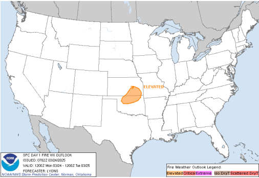
Today: Overnight moisture recovery was somewhat improved over previous days delaying the start to active burning conditions today, although warm dry and breezy conditions this afternoon will again support moderate to rapid rates of fire spread in all wildland fuel types. The strongest alignment of fire weather and receptive fuels will develop midday through early evening across northern Oklahoma stretching from northwestern Oklahoma into the north-central counties north of I-40. With respectable overnight moisture recovery and relaxing winds tonight, initial attack efforts, while challenging, are expected to be largely successful noting that large fire activity (>300 acres) is entirely possible.
Fire Behavior:
- Northwestern/Oklahoma Panhandle: Hot, dry conditions continue throughout western Oklahoma today. Fire weather conditions and critically low fuel moisture support a fire environment that will display high resistance to control wildfire. The morning humidity recovery is better today than over the past couple of days, but it is expected to return to the teens at midday. Today’s temperatures will range from 74-83 degrees, relative humidity 14-22%, and winds southwest 15-20mph with gusts up to 30mph. Fine dead fuel moisture will be 3% in the height of the burning period, noon to 1800. In rangeland areas, fire spread rates are anticipated to range between 50 and 222 feet per minute (1-2.5 mph), with flame lengths of 10-19 feet. Grass-dominated fuels will likely burn at head fire rates of spread between 113 and 547 feet per minute (2.2-6.2 mph), generating flame lengths of 11-22 feet. Areas with brush fuels, such as juniper, may experience torching and crown runs that could lead to spotting as far as 0.5 miles away.
- North-Central/Northeastern Oklahoma: Elevated to near critical fire weather conditions will develop again today. Fuel conditions are critically low, and very little green-up has occurred due to a lack of moisture after the dormant season. Greenup is expected to be delayed until rainfall occurs. Today’s temperatures will range from 73-77 degrees, relative humidity 17-22%, and winds southwest 5-10mph with gusts up to 15mph. Fine dead fuel moisture will be 3% in the height of the burning period, noon to 1800. In rangeland areas, fire spread rates are anticipated to range between 50 and 222 feet per minute (1-2.5 mph), with flame lengths of 10-19 feet. Grass-dominated fuels will burn at head fire rates of spread between 113 and 547 feet per minute (2.2-6.2 mph), generating flame lengths of 11-22 feet. Areas with brush fuels, such as juniper, may experience torching and crown runs that could lead to spotting as far as 0.5 miles away. Timber understory fuels are expected to support head fire spread rates between 40 and 176 feet per minute (1 to 2 mph), with 9 to 18-foot flame lengths. Timber litter fuel types are likely to spread at rates of 10 to 26 feet per minute, generating flame lengths of 5 to 7 feet. Additionally, brush fuels may exhibit concerning fire behavior, including torching and spotting up to 0.1 miles. A wetter weather pattern remains on track to develop mid to late week, with northward moisture returning into the region and multiple opportunities for beneficial rains in much of the area.
- Western/Southwestern Oklahoma: Elevated to near-critical fire weather conditions. Both dead and live fuel moisture levels are critically low. Today’s temperatures will range from 74-83 degrees, relative humidity 14-22%, and winds southwest 15-20mph with gusts up to 30mph. Fine dead fuel moisture will be 3% in the height of the burning period, noon to 1800. In rangeland areas, fire spread rates are anticipated to range between 50 and 222 feet per minute (1-2.5 mph), with flame lengths of 10-19 feet. Grass-dominated fuels will likely burn at head fire rates of spread between 113 and 547 feet per minute (2.2-6.2 mph), generating flame lengths of 11-22 feet. Areas with brush fuels, such as juniper, may experience torching and crown runs that could lead to spotting as far as 0.5 miles away.
- South-Central/Southeastern Oklahoma: With warmer temperatures and low relative humidity, expect elevated burning conditions today throughout southeastern Oklahoma. The wind will be lighter today, which will help lessen the spread rates. Fuel moisture conditions are still critically low. Today’s temperatures will range from 71-77 degrees, relative humidity 18-24%, and winds southwest 5-10mph with gusts up to 15mph. Fine dead fuel moisture will be 4% in the height of the burning period, noon to 1800. Timber litter fuel types are likely to spread at rates of 10 to 26 feet per minute, generating flame lengths of 5 to 7 feet.
Outlook: A weather pattern change ushering in more active weather overall, will offer some opportunity for wetting rains in the coming days with best opportunity in the south-central, southeastern and eastern counties. Given increasing soil temperature and seasonality, a shot of wetting rainfall in those areas will likely spur vigorous green-up in the herbaceous fuels while heavier brush and timber fuels remain viable given drying conditions. Unfortunately, the outlook for most of western and northwestern Oklahoma is not so optimistic. With a more unsettled weather pattern, we will be closely monitoring for fire-effective weather in those areas given the state of fuels and potential for significant fire activity in the northwestern and Panhandle Counties.
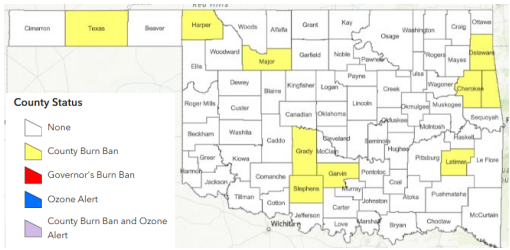
County Burn Bans: Click HERE for current burn ban information.