

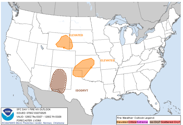
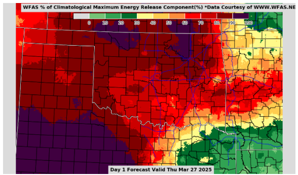
Statewide Discussion: Elevated fire weather today across the Panhandle, northwestern and far-western Oklahoma while moderated conditions are expected elsewhere. As has been previously discussed, given the composite fuel moisture along and north of I-44 less intense fire weather is required to support problematic to extreme fire behavior. As with most weather systems that traverse the Southern Great Plains during seasonal transition, there is a wet side and a fire-effective side. We will see this tomorrow and to greater extent Saturday as the dryline flexes from west to east pulsing into the Panhandle and extreme western Oklahoma tomorrow and closer to US-183 on Saturday. Energy Release Component, with direct correlation to resistance to control, has eclipsed the 80th Percentile (deep red) north of I-44 with pockets of +90th Percentile (purple). Firefighters should anticipate heavy resource commitment on any wildfire that becomes established – especially where heavier fuels are present.
A Fuels & Fire Behavior Advisory has been issued for most of the northern half of Oklahoma -Available HERE.
Today: The highest fire danger indices today will develop in the Oklahoma Panhandle and northwestern counties, while rain chances develop later today and into the overnight hours again focused in south-central to southeastern Oklahoma along the Red River. A few stray showers this morning in west-central Oklahoma and over the southern Flint Hills will provide some benefit for today, otherwise, higher relative humidity values will hold fine-dead fuel moisture above a critical threshold.
Fire Behavior:
- Northwestern/Oklahoma Panhandle: Above normal temperature in the 83°-87° range under partly-cloudy skies with afternoon relative humidity values 15-24% will yield fine-dead fuel moisture at 4% with some locations observing 3% in the western Panhandle. Southwest winds will increase into the afternoon sustained around 20 mph with some higher gusts supporting potential for rapid rates of fires spread. Rangeland fuels in the area will support head fire rates of spread 182-261 ft/min (+/- 2.1 mph) and flame lengths 13-15 ft on fully established wildfires. Southwest winds will relax slightly after sunset coupled with excellent overnight moisture recovery supporting good probability of successful initial attack noting that large fire (>300 acres) remains a concern.
- North-Central/Northeastern Oklahoma: A rather slow-moving rain shower in the southern Flint Hills over parts of Osage County will dampen fire danger concern in that isolated area, otherwise very good overnight moisture recovery leading into afternoon relative humidity values generally above 30% will lessen the potential for impactful wildfire occurrence today. Temperature in the mid-80°s with some sky cover and afternoon relative humidity values 28-35% will hold fine-dead fuel moisture at 6% today. South-southwest winds sustained 13-21 mph with a few gusts nearing 30 mph will support potential fire rapid rates of fire spread in the grass-dominated fuels. Rangeland fuels will support head fire rates of spread 157-226 ft/min and flame lengths 12-17 ft. Where brush fuels, including juniper, are present, expect single/group tree torching coupled with short-range spotting. Fire weather relaxes further after sunset with excellent overnight moisture recovery anticipated offering good probability for successful initial attack efforts. Given some favorable conditions, it is expected that private lands prescribed/controlled burning will be prevalent in the area.
- Western/Southwestern Oklahoma: With atmospheric moisture in place, relative humidity values are not expected to dip below 30% in most locations as temperature warms into the 79°-83° range. Fine-dead fuel moisture will hover around 6% this afternoon while composite fuel moisture remains very dry pointing to high resistance to control on any established wildfire. As daytime heating increases, southerly winds will also increase to 16-21 mph gusting around 30 mph supporting potential for rapid rates of fire spread. Rangeland fuels will support head fire rates of spread 145-208 ft/min and flame lengths 11-15 ft during peak burning conditions. Excellent overnight moisture recovery will support very good opportunity for successful initial attack efforts noting that large fire occurrence cannot be ruled out.
- South-Central/Southeastern Oklahoma: Wetting rainfall amounts in far south-central Oklahoma combined with soil temperature nearing 60° will support vigorous green-up in the coming days and seasonality is pushing budding on many of the woody species. Rain chances develop over a similar footprint as yesterday into the evening and overnight. Given those areas of rainfall and higher afternoon relative humidity values limiting fine-dead fuel receptiveness, fire behavior will be a bit more muted today. Temperature 77°-83° with some sky cover and afternoon relative humidity values >35% will hold 1-Hr fuel moisture to =/+7% this afternoon. South winds 7-13 mph with some higher gusts will yield fire spread potential in grass-dominated fuels to less than 90 ft/min affording excellent probability of successful initial attack. Timber fuel types will exhibit ROS +/- 20 ft/min and FL 1.5-4 ft. Rain chances overnight and excellent overnight moisture recovery will halt burning conditions this evening.
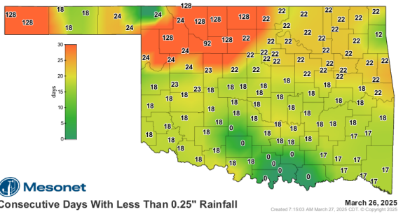
Outlook: Large and significant fire occurrence concern has subsided for a few days affording fire crews good opportunity control recent wildfires. Elevated concern remains in place now and through the near-term forecast focused on northwestern Oklahoma and surrounding areas where there is little (or nil) optimism for wetting rains in the current 7-Day Quantitative Precipitation Forecast. This is compounded by the notable area spanning across the northwestern counties from I-35 west through the Oklahoma Panhandle where persistent lack of precipitation and drying conditions have thrust composite fuel moisture into critical concern. During the seasonal transition, much more dynamic weather systems are expected to have both a storm side and a fire-effective side often predicated by dryline intrusion and subsequent cold front passage. While no critical fire weather is evident in the near-term forecast, we need to remain mindful of two things: 1) Given current fuel moisture profiles, less intense fire weather is required to support problematic and extreme fire behavior. And, 2) Vigilance in discerning dynamic forecast components is required to fully assess wildland fire occurrence and severity in the predicted environment.
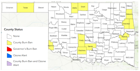
County Burn Bans: Click HERE for current burn ban information.
Click here to see today’s Fire Situation Report.


